In the interim this week, I got the wiki page up for tag:reporting_marks,
and started using the tag in my area as a bit of a test - we had the
thought that if there proved to be a better tag to hold this info, since
this is a "novel" tag, it'd be easy to query out places we'd used it and
just switch it to the more appropriate tag.  Meanwhile, we could at least
start entering the info we needed to eventually make the rail map show the
information North American rail users expect.
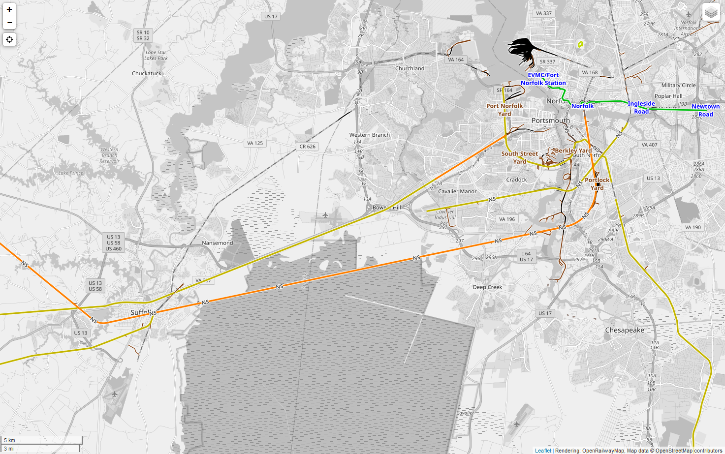
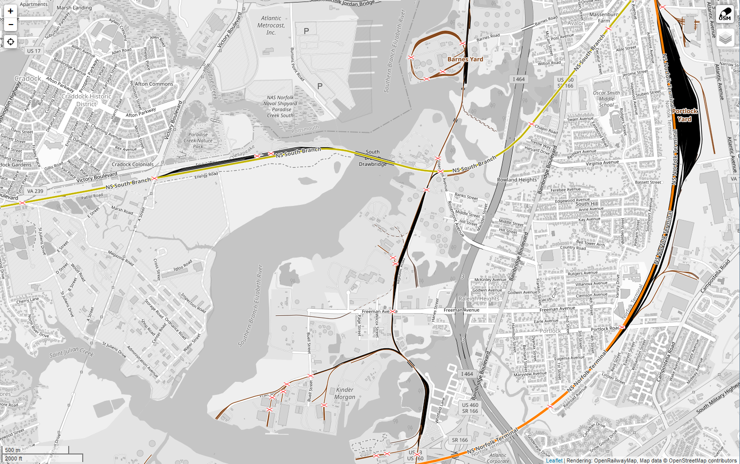
Turns out, there IS a better tag already, and it's *really* obvious, if you
know much about European rail networks ... which I don't, on the whole.
The best tag to use was already in the default tag scheme, but I glossed
over it based on its description, since nothing like it is used in North
American rail networks.

Long story short, in NA rail networks, we should be storing the reporting
marks in the ref=* tag on the way, and in a "pretty" way, as this tag is
directly rendered as part of the label.

I missed this, because the description of that tag in the
OpenRailwayMap/Tagging page is just, "The reference number of the railway
line the track belongs to."  There's no such thing as a track reference
number anywhere in NA, it's literally a foreign concept on this side of the
Atlantic.  I suspect the description is so short, because it turns out the
fine folks in Germany (where this tagging scheme was first developed)
number their railway routes like we number highways in NA. This became
blindingly obvious when I took a better look at both some of the better
developed areas of the German map (which are WAY beyond the point we're at
here, unfortunately for us at least), and started poking through the MapCSS
style definition for the ORM renderer.

I tried this out locally yesterday, and gave the server time to re-render
the tiles.  If you put the reporting marks in the ref tag, which is
otherwise used for absolutely nothing in NA and likely never would be, it
works *beautifully* on the ORM render. A line with ref
<https://wiki.openstreetmap.org/wiki/Key:ref>=NS
<https://wiki.openstreetmap.org/w/index.php?title=Tag:ref%3DNS&action=edit&redlink=1>
and name <https://wiki.openstreetmap.org/wiki/Key:name>=South Branch
<https://wiki.openstreetmap.org/w/index.php?title=Tag:name%3DSouth_Branch&action=edit&redlink=1>
renders perfectly as "NS South Branch" at zooms >= 15, and as just "NS" at
zooms 12-14, and with no tag at zooms <12. This is *exactly* the labeling
style expected on a standard North American rail map - finally! And no
modifications to the renderer necessary to make it work perfectly. I've
uploaded samples at Zoom 12
<http://www.aturnofthenut.com/wp-content/uploads/2020/06/2020_06_12_18_37_29_OpenRailwayMap-12.png>
and at Zoom 15
<http://www.aturnofthenut.com/wp-content/uploads/2020/06/2020_06_12_18_40_25_OpenRailwayMap-15.png>
for comparison.

For any non-NA readers who might be just as confused about the desirability
of that tagging style as I was about nice, sensible railway route numbers,
that has been the default labeling of rail maps in NA for around 150
years.  The label is occasionally the spelled out operator name, but most
commonly (better than 90% of examples) the operator reporting marks, which
serve as a standardized shorthand.  Even the names, as we tag them in the
name field, are rarely used to refer to the lines, and are essentially
never used on mapping here.  They're the absolute last-choice designator,
and you *really* have to hunt to find any rail map in the US (including by
the operators) that labels any line by name.  This is in large part because
railway lines in the US have always almost exclusively been privately
owned, so in almost all cases the operator is effectively synonymous with
the route name (especially up to about 1950; before the huge wave of
national mergers started, each operator had one major route that was just
known by their operator name).  You never see a map labeled by route names,
it'd be the reporting marks with either an informal descriptive name (e.g.
NS Washington-to-Atlanta line), or most often a double reference that gives
the current and pre-mergers operator (e.g. NS ex-SOU), because that ex-
operator takes you back to 1950 where it identifies a single line.  That's
the US industry standard.

So, this tag scheme gets us the best of both worlds - a map that's actually
usable by a North American rail map consumer (which the current map is very
much not due to lack of operator labeling), a name which is still
consistent with the general OSM and ORM guidelines for wanting to apply
some sort of name, and all of it with zero change needed to the ORM
rendering settings to produce a usable map.  No special style, it's
perfectly usable as-is with the default worldwide rendering style.  You can
pan from Germany to the US and get a map that's exactly what people in the
region expect to see and use, all with no special settings.

The only thing we'll have to do a little different is the presentation of
the ref data, because it's directly rendered.  Rather than semicolon
delimiters like we proposed for reporting_marks, when there are multiple
operators (one owner, one or more with trackage rights), the appropriate
way to fill out the field would be e.g. "NS (AC, NPBL)" where NS is the
owner-operator and the other two are trackage rights holders.  This is
another NA mapping standard that's about 150 years old, and is essentially
mandatory to make this a functional rail map for this part of the world.

All that said - input?  Are there any objections to going that route, since
it both solves so many problems, and simplifies fixing the big rendering
issue we currently have?

I have to say thanks to Volker, too, for his input on this last week - it
was his suggestion to look for a more "international" tag that actually
spurred me to dig through the completed European maps and the rendering
definitions this week to see if this wasn't an already-solved problem that
we Yanks just hadn't realized yet.

Chuck
Virginia
_______________________________________________
Talk-us mailing list
Talk-us@openstreetmap.org
https://lists.openstreetmap.org/listinfo/talk-us