    Date: Sunday, March 12, 2023 @ 16:30:29
  Author: jelle
Revision: 1419374
archrelease: copy trunk to community-x86_64
Added:
gpscorrelate/repos/community-x86_64/PKGBUILD
(from rev 1419373, gpscorrelate/trunk/PKGBUILD)
gpscorrelate/repos/community-x86_64/io.github.dfandrich.gpscorrelate.metainfo.xml
(from rev 1419373,
gpscorrelate/trunk/io.github.dfandrich.gpscorrelate.metainfo.xml)
Deleted:
gpscorrelate/repos/community-x86_64/PKGBUILD
gpscorrelate/repos/community-x86_64/io.github.dfandrich.gpscorrelate.metainfo.xml
-----------------------------------------------+
PKGBUILD | 68 +++++++++++------------
io.github.dfandrich.gpscorrelate.metainfo.xml | 70 ++++++++++++------------
2 files changed, 69 insertions(+), 69 deletions(-)
Deleted: PKGBUILD
===================================================================
--- PKGBUILD 2023-03-12 16:30:21 UTC (rev 1419373)
+++ PKGBUILD 2023-03-12 16:30:29 UTC (rev 1419374)
@@ -1,34 +0,0 @@
-# Maintainer: Balló György <ballogyor+arch at gmail dot com>
-# Contributor: Hinrich Harms <[email protected]>
-# Contributor: sylvain alborini <[email protected]>
-
-pkgname=gpscorrelate
-pkgver=2.0
-pkgrel=3
-pkgdesc='Correlate (geotagging) digital camera photos with GPS data in GPX
format'
-arch=('x86_64')
-url='https://dfandrich.github.io/gpscorrelate/'
-license=('GPL2')
-depends=('exiv2' 'gtk3')
-makedepends=('libxslt')
-source=("https://github.com/dfandrich/$pkgname/releases/download/$pkgver/$pkgname-$pkgver.tar.xz";
- 'io.github.dfandrich.gpscorrelate.metainfo.xml')
-sha256sums=('3fba8ad72b9b42dfc870a04d1207357c2a6c28842b1ede51e28b30a93b48debe'
- '3e12e59fff65ae03f7e39910c0c243401fca372fabe8af4539ef3e57f3b71824')
-
-prepare() {
- cd $pkgname-$pkgver
- sed -e '/^CFLAGS =/d' -e '/^LDFLAGS =/d' -i Makefile # Honor system build
flags
-}
-
-build() {
- cd $pkgname-$pkgver
- make prefix=/usr
-}
-
-package() {
- cd $pkgname-$pkgver
- make prefix=/usr DESTDIR="$pkgdir" install install-desktop-file
- install -Dm644 ../io.github.dfandrich.gpscorrelate.metainfo.xml \
- "$pkgdir/usr/share/metainfo/io.github.dfandrich.gpscorrelate.metainfo.xml"
-}
Copied: gpscorrelate/repos/community-x86_64/PKGBUILD (from rev 1419373,
gpscorrelate/trunk/PKGBUILD)
===================================================================
--- PKGBUILD (rev 0)
+++ PKGBUILD 2023-03-12 16:30:29 UTC (rev 1419374)
@@ -0,0 +1,34 @@
+# Maintainer: Balló György <ballogyor+arch at gmail dot com>
+# Contributor: Hinrich Harms <[email protected]>
+# Contributor: sylvain alborini <[email protected]>
+
+pkgname=gpscorrelate
+pkgver=2.0
+pkgrel=4
+pkgdesc='Correlate (geotagging) digital camera photos with GPS data in GPX
format'
+arch=('x86_64')
+url='https://dfandrich.github.io/gpscorrelate/'
+license=('GPL2')
+depends=('exiv2' 'gtk3')
+makedepends=('libxslt')
+source=("https://github.com/dfandrich/$pkgname/releases/download/$pkgver/$pkgname-$pkgver.tar.xz";
+ 'io.github.dfandrich.gpscorrelate.metainfo.xml')
+sha256sums=('3fba8ad72b9b42dfc870a04d1207357c2a6c28842b1ede51e28b30a93b48debe'
+ '3e12e59fff65ae03f7e39910c0c243401fca372fabe8af4539ef3e57f3b71824')
+
+prepare() {
+ cd $pkgname-$pkgver
+ sed -e '/^CFLAGS =/d' -e '/^LDFLAGS =/d' -i Makefile # Honor system build
flags
+}
+
+build() {
+ cd $pkgname-$pkgver
+ make prefix=/usr
+}
+
+package() {
+ cd $pkgname-$pkgver
+ make prefix=/usr DESTDIR="$pkgdir" install install-desktop-file
+ install -Dm644 ../io.github.dfandrich.gpscorrelate.metainfo.xml \
+ "$pkgdir/usr/share/metainfo/io.github.dfandrich.gpscorrelate.metainfo.xml"
+}
Deleted: io.github.dfandrich.gpscorrelate.metainfo.xml
===================================================================
--- io.github.dfandrich.gpscorrelate.metainfo.xml 2023-03-12 16:30:21 UTC
(rev 1419373)
+++ io.github.dfandrich.gpscorrelate.metainfo.xml 2023-03-12 16:30:29 UTC
(rev 1419374)
@@ -1,35 +0,0 @@
-<?xml version="1.0" encoding="UTF-8"?>
-<component type="desktop-application">
- <id>io.github.dfandrich.gpscorrelate</id>
- <metadata_license>CC0-1.0</metadata_license>
- <project_license>GPL-2.0+</project_license>
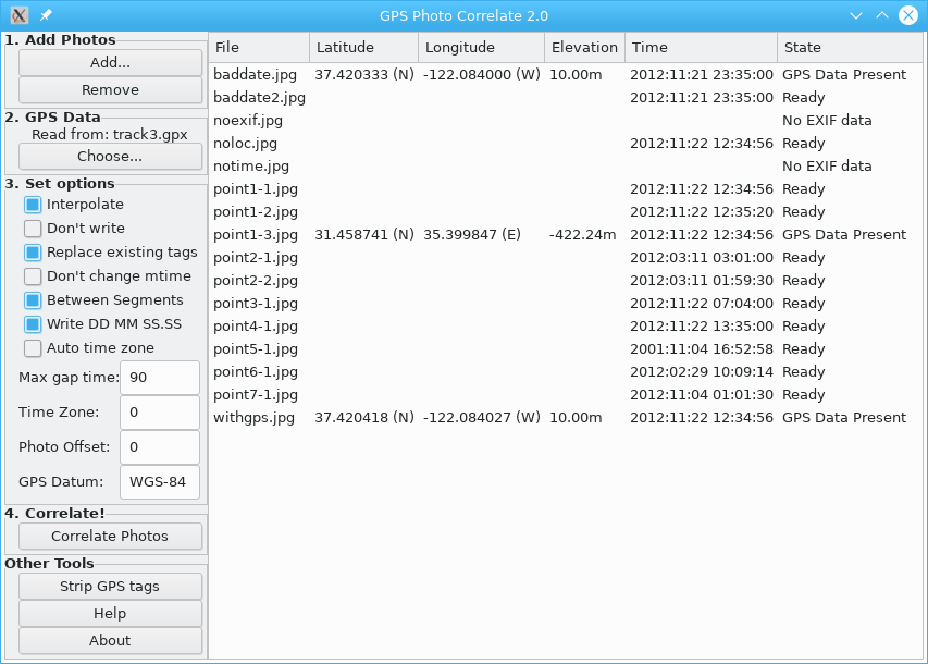
- <name>GPS Correlate</name>
- <summary>GPS Correlate attaches EXIF GPS location tags to images</summary>
- <summary xml:lang="de">GPS Correlate fügt Bildern EXIF
GPS-Standort-Metadaten bei</summary>
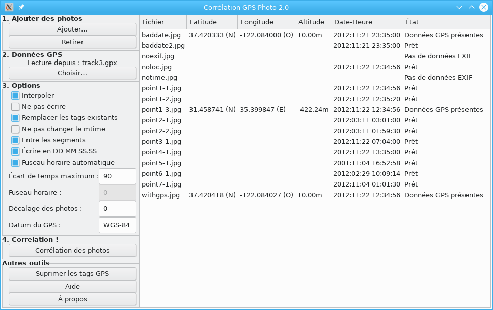
- <summary xml:lang="fr">GPS Correlate attache des tags de position GPS EXIF
aux images</summary>
- <summary xml:lang="ru">GPS Correlate прикрепляет к изображениям теги
местоположения GPS EXIF</summary>
- <description>
- <p>GPS Correlate takes a GPS track stored by any of a number of GPS
devices and phone apps and correlates the time stamp of a digital photo with
the location of the track at that same moment. The location of the image is
then stamped directly into the image file using the appropriate EXIF GPS tags.
The resulting image then contains not just the time the photo was taken but its
exact location, too. The location is used by various other applications and
services (such as Google Photos) to display a map of where the photo was
taken.</p>
- <p xml:lang="de">GPS Correlate nimmt eine GPS-Track auf, die von einer
Zahl von GPS-Geräten und Telefon-Apps gespeichert wurde, und korreliert den
Zeitstempel eines Digitalfotos mit der Position der Spur im selben Moment. Der
Standort des Bildes wird dann unter Verwendung der entsprechenden EXIF-GPS-Tags
direkt in die Bilddatei gestempelt. Das resultierende Bild enthält dann nicht
nur den Zeitpunkt, zu dem das Foto aufgenommen wurde, sondern auch seine genaue
Position. Der Standort wird von verschiedenen anderen Anwendungen und Diensten
(z.B. Google Photos) verwendet, um eine Karte des Aufnahmeortes des Fotos
anzuzeigen.</p>
- </description>
- <screenshots>
- <screenshot type="default">
- <image
xml:lang="en">https://dfandrich.github.io/gpscorrelate/corr.png</image>
- <image
xml:lang="fr">https://dfandrich.github.io/gpscorrelate/fr/corr.png</image>
- </screenshot>
- </screenshots>
- <url type="homepage">https://dfandrich.github.io/gpscorrelate</url>
- <url type="help">https://dfandrich.github.io/gpscorrelate/gui.html</url>
- <url type="bugtracker">https://github.com/dfandrich/gpscorrelate/issues</url>
- <url
type="translate">https://github.com/dfandrich/gpscorrelate/tree/master/po</url>
- <update_contact>dan_at_coneharvesters.com</update_contact>
- <launchable type="desktop-id">gpscorrelate.desktop</launchable>
- <kudos>
- <kudo>HiDpiIcon</kudo>
- <kudo>ModernToolkit</kudo>
- <kudo>UserDocs</kudo>
- </kudos>
- <translation type="gettext">gpscorrelate</translation>
- <developer_name>Daniel Fandrich</developer_name>
- <content_rating type="oars-1.1"/>
-</component>
Copied:
gpscorrelate/repos/community-x86_64/io.github.dfandrich.gpscorrelate.metainfo.xml
(from rev 1419373,
gpscorrelate/trunk/io.github.dfandrich.gpscorrelate.metainfo.xml)
===================================================================
--- io.github.dfandrich.gpscorrelate.metainfo.xml
(rev 0)
+++ io.github.dfandrich.gpscorrelate.metainfo.xml 2023-03-12 16:30:29 UTC
(rev 1419374)
@@ -0,0 +1,35 @@
+<?xml version="1.0" encoding="UTF-8"?>
+<component type="desktop-application">
+ <id>io.github.dfandrich.gpscorrelate</id>
+ <metadata_license>CC0-1.0</metadata_license>
+ <project_license>GPL-2.0+</project_license>
+ <name>GPS Correlate</name>
+ <summary>GPS Correlate attaches EXIF GPS location tags to images</summary>
+ <summary xml:lang="de">GPS Correlate fügt Bildern EXIF
GPS-Standort-Metadaten bei</summary>
+ <summary xml:lang="fr">GPS Correlate attache des tags de position GPS EXIF
aux images</summary>
+ <summary xml:lang="ru">GPS Correlate прикрепляет к изображениям теги
местоположения GPS EXIF</summary>
+ <description>
+ <p>GPS Correlate takes a GPS track stored by any of a number of GPS
devices and phone apps and correlates the time stamp of a digital photo with
the location of the track at that same moment. The location of the image is
then stamped directly into the image file using the appropriate EXIF GPS tags.
The resulting image then contains not just the time the photo was taken but its
exact location, too. The location is used by various other applications and
services (such as Google Photos) to display a map of where the photo was
taken.</p>
+ <p xml:lang="de">GPS Correlate nimmt eine GPS-Track auf, die von einer
Zahl von GPS-Geräten und Telefon-Apps gespeichert wurde, und korreliert den
Zeitstempel eines Digitalfotos mit der Position der Spur im selben Moment. Der
Standort des Bildes wird dann unter Verwendung der entsprechenden EXIF-GPS-Tags
direkt in die Bilddatei gestempelt. Das resultierende Bild enthält dann nicht
nur den Zeitpunkt, zu dem das Foto aufgenommen wurde, sondern auch seine genaue
Position. Der Standort wird von verschiedenen anderen Anwendungen und Diensten
(z.B. Google Photos) verwendet, um eine Karte des Aufnahmeortes des Fotos
anzuzeigen.</p>
+ </description>
+ <screenshots>
+ <screenshot type="default">
+ <image
xml:lang="en">https://dfandrich.github.io/gpscorrelate/corr.png</image>
+ <image
xml:lang="fr">https://dfandrich.github.io/gpscorrelate/fr/corr.png</image>
+ </screenshot>
+ </screenshots>
+ <url type="homepage">https://dfandrich.github.io/gpscorrelate</url>
+ <url type="help">https://dfandrich.github.io/gpscorrelate/gui.html</url>
+ <url type="bugtracker">https://github.com/dfandrich/gpscorrelate/issues</url>
+ <url
type="translate">https://github.com/dfandrich/gpscorrelate/tree/master/po</url>
+ <update_contact>dan_at_coneharvesters.com</update_contact>
+ <launchable type="desktop-id">gpscorrelate.desktop</launchable>
+ <kudos>
+ <kudo>HiDpiIcon</kudo>
+ <kudo>ModernToolkit</kudo>
+ <kudo>UserDocs</kudo>
+ </kudos>
+ <translation type="gettext">gpscorrelate</translation>
+ <developer_name>Daniel Fandrich</developer_name>
+ <content_rating type="oars-1.1"/>
+</component>