echarts-bot[bot] commented on issue #16777:
URL: https://github.com/apache/echarts/issues/16777#issuecomment-1083939635
@751974841 It seems you are not using English, I've helped translate the
content automatically. To make your issue understood by more people and get
helped, we'd like to suggest using English next time. 🤗
<details><summary><b>TRANSLATED</b></summary><br>
**BODY**
### Version
4.2.1
### Link to Minimal Reproduction
_No response_
### Steps to Reproduce
1. // Make related configuration
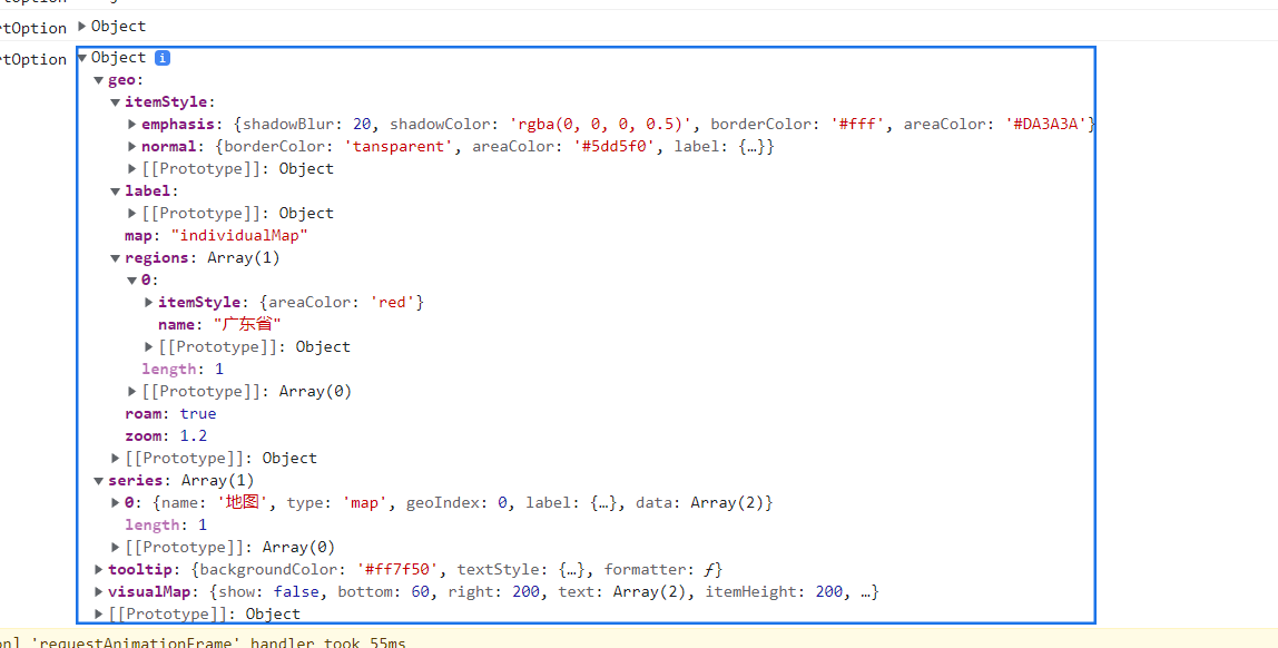
this.chartOption = {
tooltip: {
//Move the mouse to the floating prompt box in the picture
// formatter detailed configuration:
https://echarts.baidu.com/option.html#tooltip.formatter
formatter(params, ticket, callback) {
// params.data is the data traversal in the series configuration
item
let localValue = 0,
perf = 0,
downloadSpeep,
usability,
point;
if (params.data) {
localValue = params.data.count ? params.data.count : 0;
downloadSpeep = params.data.downloadSpeep;
usability = params.data.usability;
point = params.data.point;
}
let htmlStr = `
<div style='font-size:18px;'> ${params.name}</div>
<p style='text-align:left;margin-top:-4px;'>
Number of items: ${localValue}<br/>
</p>
`;
return htmlStr;
},
backgroundColor: "#ff7f50", //Background color of prompt label
textStyle: { color: "#fff" }, //The font color of the prompt label
},
visualMap: {
show: false,
bottom: 60,
right: 200,
text: ["High", "Low"],
// min:0,
// precision:0,
itemHeight: 200,
color: [
"#5475f5",
"#9feaa5",
"#85daef",
"#74e2ca",
"#e6ac53",
"#9fb5ea",
],
},
// Detailed explanation of geo configuration:
https://echarts.baidu.com/option.html#geo
geo: {
// The geographic coordinate system component is used for map
drawing
map: "individualMap", // Indicates the map of China. If China has
the southern islands
roam: true, // whether to enable mouse zoom and pan roaming
zoom: 1.2, // the zoom ratio of the current viewing angle (the
zoom ratio of the map)
label: {
// show: true
},
itemStyle: {
// The polygon graphic style for the map area.
normal: {
// unchecked state
borderColor: "tansparent",
areaColor: "#5dd5f0", //background color
label: {
// show: true, // show name
},
},
emphasis: {
//selected state
// Polygon and label styles in highlighted state
shadowBlur: 20,
shadowColor: "rgba(0, 0, 0, 0.5)",
borderColor: "#fff",
areaColor: "#DA3A3A",
},
},
regions: [
{
name: "Guangdong Province",
itemStyle: {
areaColor: "red",
color: "red",
},
},
],
},
series: [
{
name: "Map", // The title of the floating box (the formatter
above customizes the prompt box data, so it is not necessary to write it here)
type: "map",
geoIndex: 0,
label: {
show: true,
},
// This is the data of a certain area on the map that needs to
be configured, and spliced according to the returned data in the background
data: [...this.mapInfo[this.type].data],
},
],
};
2.
### Current Behavior
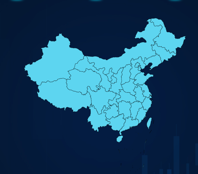
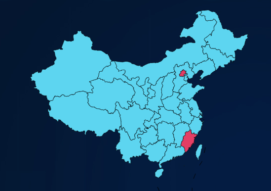
1.it is normal in devlopment enviroment but it will be a problem in a
production enviroment
2. the fitst picture shows the params and the second picture shows the map
in production enviroment
3. the final picture shows normally in development enviroment
### Expected Behavior
1.I can normally distribute this in production enviroment
### Environment
````markdown
- OS:window
- Browser:chrome
- Framework:vue^2.6.10
````
### Any additional comments?
_No response_
</details>
--
This is an automated message from the Apache Git Service.
To respond to the message, please log on to GitHub and use the
URL above to go to the specific comment.
To unsubscribe, e-mail: commits-unsubscr...@echarts.apache.org
For queries about this service, please contact Infrastructure at:
us...@infra.apache.org
---------------------------------------------------------------------
To unsubscribe, e-mail: commits-unsubscr...@echarts.apache.org
For additional commands, e-mail: commits-h...@echarts.apache.org