Thanks a lot for the feedback guys. Simply using interpolation to do the
smoothing makes a lot of sense! Thanks Simone. I am going to experiment a
bit more and I’ll come back with my findings.
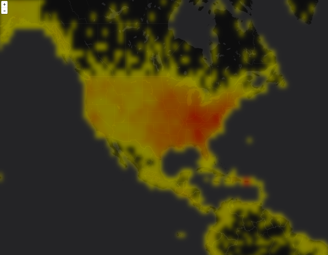
On Fri, Apr 8, 2016 at 7:09 AM Simone Giannecchini <
[email protected]> wrote:

> Ciao Justin,
> adding to Andrea's, please, read below...
>
> Regards,
> Simone Giannecchini
> ==
> GeoServer Professional Services from the experts!
> Visit http://goo.gl/it488V for more information.
> ==
> Ing. Simone Giannecchini
> @simogeo
> Founder/Director
>
> GeoSolutions S.A.S.
> Via di Montramito 3/A
> 55054  Massarosa (LU)
> Italy
> phone: +39 0584 962313
> fax:     +39 0584 1660272
> mob:   +39  333 8128928
>
> http://www.geo-solutions.it
> http://twitter.com/geosolutions_it
>
> -------------------------------------------------------
> AVVERTENZE AI SENSI DEL D.Lgs. 196/2003
> Le informazioni contenute in questo messaggio di posta elettronica e/o
> nel/i file/s allegato/i sono da considerarsi strettamente riservate.
> Il loro utilizzo è consentito esclusivamente al destinatario del
> messaggio, per le finalità indicate nel messaggio stesso. Qualora
> riceviate questo messaggio senza esserne il destinatario, Vi preghiamo
> cortesemente di darcene notizia via e-mail e di procedere alla
> distruzione del messaggio stesso, cancellandolo dal Vostro sistema.
> Conservare il messaggio stesso, divulgarlo anche in parte,
> distribuirlo ad altri soggetti, copiarlo, od utilizzarlo per finalità
> diverse, costituisce comportamento contrario ai principi dettati dal
> D.Lgs. 196/2003.
>
> The information in this message and/or attachments, is intended solely
> for the attention and use of the named addressee(s) and may be
> confidential or proprietary in nature or covered by the provisions of
> privacy act (Legislative Decree June, 30 2003, no.196 - Italy's New
> Data Protection Code).Any use not in accord with its purpose, any
> disclosure, reproduction, copying, distribution, or either
> dissemination, either whole or partial, is strictly forbidden except
> previous formal approval of the named addressee(s). If you are not the
> intended recipient, please contact immediately the sender by
> telephone, fax or e-mail and delete the information in this message
> that has been received in error. The sender does not give any warranty
> or accept liability as the content, accuracy or completeness of sent
> messages and accepts no responsibility  for changes made after they
> were sent or for other risks which arise as a result of e-mail
> transmission, viruses, etc.
>
>
> On Thu, Apr 7, 2016 at 7:56 PM, Andrea Aime
> <[email protected]> wrote:
> > On Wed, Apr 6, 2016 at 10:02 PM, Justin Deoliveira <[email protected]>
> > wrote:
> >>
> >> Hi folks,
> >>
> >> I’m working on a project to expose Solr’s heatmap capability through
> >> GeoServer. You can find details about Solr heatmaps here:
> >>
> >>     https://cwiki.apache.org/confluence/display/solr/Spatial+Search
> >> (search for “Heatmap Faceting”.
> >>
> >> But the gist of it is this: If you have a spatial field that uses the
> >> recursive prefix tree type (ie. geohash) for indexing then it’s easy
> using
> >> Solr’s facetting infrastructure to generate a heatmap grid. What you get
> >> back from Solr is a 2D array representing the geohash grid, where each
> value
> >> is a count of documents that intersect that grid cell. Applying some
> >> symbolization you can get something that looks like this:
> >>
> >>
> >>
> https://raw.githubusercontent.com/voyagersearch/leaflet-solr-heatmap/master/sample.png
> >>
> >> The above screen shot comes from a leaflet plugin that visualizes the
> >> heatmap directly in the browser. I would like to add a similar looking
> >> visualization for GeoTools/GeoServer.
> >>
> >> My first thought was to expose this as a new type of coverage reader,
> >> since the data is simple grid it falls into the model quite easily. The
> >> major benefit of this approach is that becomes trivial to configure in
> >> GeoServer and easy to style using all of the existing raster symbology
> >> support. I’m interested to hear if others think this is a good approach.
> >
> >
> > I believe it is. You might want have a look at how the sde coverage
> reader
> > was setup, to share the same connection
> > info as a vector solr store (downside, you first have to setup a vector
> > store).
> >
> >>
> >>
> >> If that sounds good my plan was to add this to the existing solr module.
> >> It won’t add any new dependencies aside from a dependency on the
> coverage
> >> module.
> >>
> >> @Andrea: you’re listed as the module maintainer… although if I recall
> >> correctly we agreed to co-maintain the module?
> >
> >
> > We did, just add yourself in the pom :-)
> >
> >>
> >>
> >> I have a prototype working so if that all sounds good I’ll push up a
> >> branch for folks to look at.
> >
> >
> > Great
> >
> >>
> >> One thing I am particular eager to get some feed back on is how to best
> >> achieve the blur affect that makes heatmaps look “
> >> pretty”. At the moment what I have done is baked in a parameter to the
> >> coverage format that specifies a blur radius and then when reading the
> >> coverage I run it through the Convolve operation to achieve the desired
> >> affect. It would be ideal if this could be done at symbolization time.
> I’m
> >> wondering if we currently have any way to define a blur or some similar
> >> effect at rendering time with sld? Would a rendering transform work?
> >
> >
> > I don't think we have a blur operation, a rendering transform would
> likely
> > do the trick with the smallest effort.
> > In an ideal world, it would be nice to have a FTS level vendor parameter
> to
> > perform blurring just like we do color composition
> > but I guess that might be more complex to implement.
>
> Thinking...
> I had a quick look at the output of the SOLR heatmap and (as I
> expected) what we get from it are numbers.
>
> To make this look pretty you might want to perform smooting even by
> simply doing a bilinear or bicubic interpolation, you do not really
> need anything as fancy as a kernel operation.
> For this we could use the existing scale rendering transformation that
> also supports interpolation as a parameter; it should work by doing an
> identity transform with higher order interpolation (biliner or
> bicubic).
>
> Next step would be to apply a color map on top.
>
> >
> > Cheers
> > Andrea
> >
> > --
> > ==
> > GeoServer Professional Services from the experts! Visit
> > http://goo.gl/it488V for more information.
> > ==
> >
> > Ing. Andrea Aime
> > @geowolf
> > Technical Lead
> >
> > GeoSolutions S.A.S.
> > Via di Montramito 3/A
> > 55054  Massarosa (LU)
> > phone: +39 0584 962313
> > fax: +39 0584 1660272
> > mob: +39  339 8844549
> >
> > http://www.geo-solutions.it
> > http://twitter.com/geosolutions_it
> >
> > AVVERTENZE AI SENSI DEL D.Lgs. 196/2003
> >
> > Le informazioni contenute in questo messaggio di posta elettronica e/o
> nel/i
> > file/s allegato/i sono da considerarsi strettamente riservate. Il loro
> > utilizzo è consentito esclusivamente al destinatario del messaggio, per
> le
> > finalità indicate nel messaggio stesso. Qualora riceviate questo
> messaggio
> > senza esserne il destinatario, Vi preghiamo cortesemente di darcene
> notizia
> > via e-mail e di procedere alla distruzione del messaggio stesso,
> > cancellandolo dal Vostro sistema. Conservare il messaggio stesso,
> divulgarlo
> > anche in parte, distribuirlo ad altri soggetti, copiarlo, od utilizzarlo
> per
> > finalità diverse, costituisce comportamento contrario ai principi dettati
> > dal D.Lgs. 196/2003.
> >
> >
> >
> > The information in this message and/or attachments, is intended solely
> for
> > the attention and use of the named addressee(s) and may be confidential
> or
> > proprietary in nature or covered by the provisions of privacy act
> > (Legislative Decree June, 30 2003, no.196 - Italy's New Data Protection
> > Code).Any use not in accord with its purpose, any disclosure,
> reproduction,
> > copying, distribution, or either dissemination, either whole or partial,
> is
> > strictly forbidden except previous formal approval of the named
> > addressee(s). If you are not the intended recipient, please contact
> > immediately the sender by telephone, fax or e-mail and delete the
> > information in this message that has been received in error. The sender
> does
> > not give any warranty or accept liability as the content, accuracy or
> > completeness of sent messages and accepts no responsibility  for changes
> > made after they were sent or for other risks which arise as a result of
> > e-mail transmission, viruses, etc.
> >
> >
> > -------------------------------------------------------
> >
> >
> ------------------------------------------------------------------------------
> >
> > _______________________________________________
> > GeoTools-Devel mailing list
> > [email protected]
> > https://lists.sourceforge.net/lists/listinfo/geotools-devel
> >
>
------------------------------------------------------------------------------
_______________________________________________
GeoTools-Devel mailing list
[email protected]
https://lists.sourceforge.net/lists/listinfo/geotools-devel