Well I think I'm rapidly approaching the end of the window I had to work
with this and figure out how to add it to osm, if anyone else wants to try,
go for it.  In the meantime, I just figured out how to turn it into a kml,
it contains sites in addition to those mapped by British Geological Survey,
Durham University, ICIMOD, NASA-JPL, Univ. of Arizona -- though one
coincides: theirs: 20150508_hazard_db:FID 120 this eq_kml_shp:id -80 and
eq_kml_shp:id -81. Their db is available at:
https://data.hdx.rwlabs.org/dataset/lands
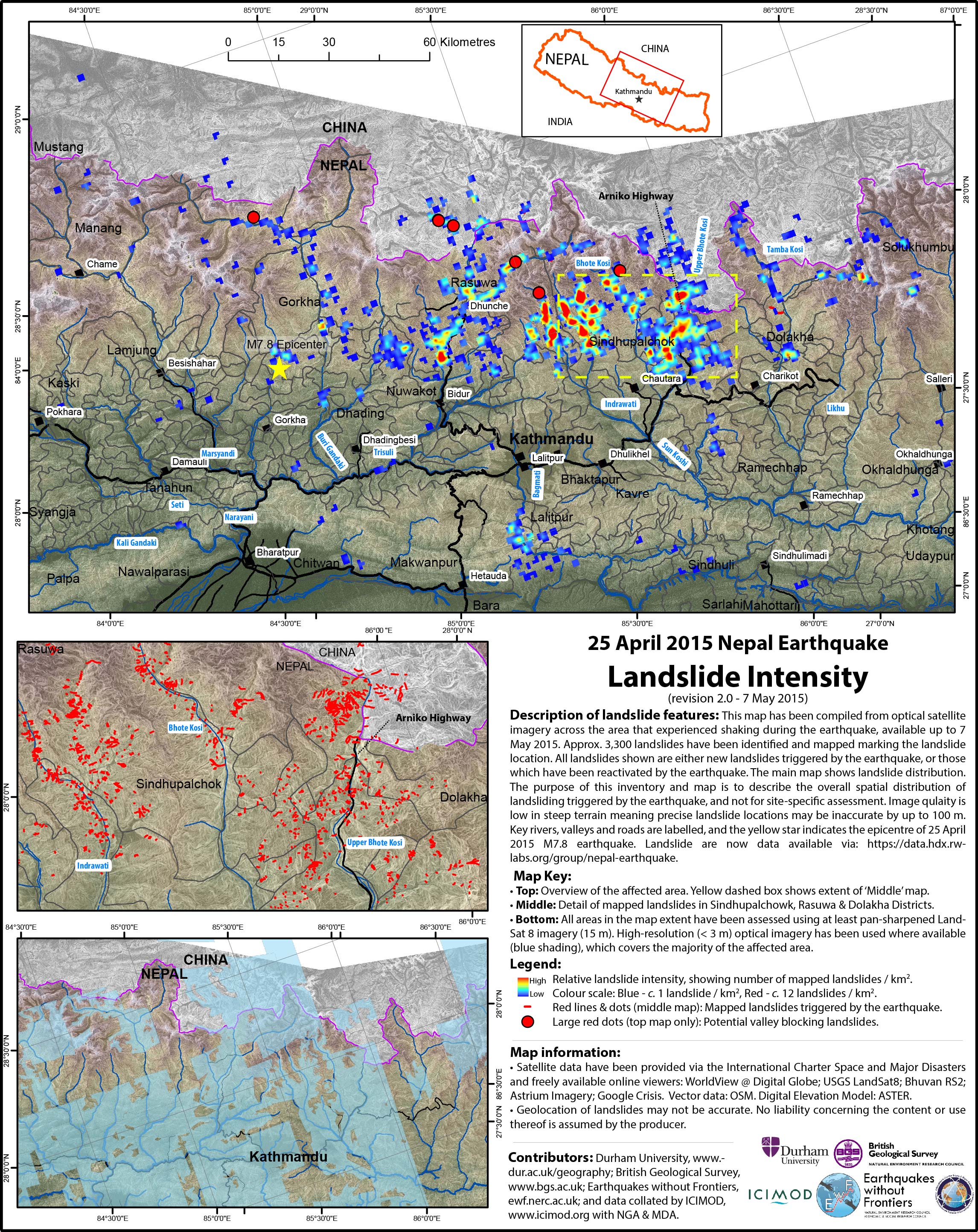
This kmz here (rougher than I'd like but it will have to do... ) All the best, John On Mon, May 11, 2015 at 8:59 AM, john o'l <ol.john...@gmail.com> wrote: > Also linking a website with links to a report on the Oso landslide as it > is somewhat familiar to me > http://www.geerassociation.org/GEER_Post%20EQ%20Reports/Oso_WA_2014/index.html > For our purposes, some of the key points made are: the initial phase of > the slide (most destructive/fastest and most distant runout) -- was an old > slide that had remobilized. 200 vertical meters of material which covered a > horizontal distance of 1000 meters. So existing landslides can remain very > dangerous for a considerable period of time. The 1 km runout, (or > "deposit" keeping with the tagging scheme I proposed "area = deposit") was > not extraordinary based on volume of material, however it was extraordinary > relative to most peoples' perceptions -- I doubt anyone seriously > considered that a hillside that low and distant could be an active risk to > an area as far away as the main highway corridor. > > After mapping some more landslides to my local machine but yet to upload > any to OSM, I'd like to update my proposed OSM tagging scheme: > > hazard_type = landslide > hazard_prone = yes > area = scarp OR deposit > damage:event = nepal_earthquake_2015 OR pre_nepal_earthquake_2015 > barrier = scarp OR deposit > source = DigitalGlobe, 2015-05 OR other as appropriate > landuse = brownfield > > Cheers, > > John > > On Mon, May 11, 2015 at 8:00 AM, john o'l <ol.john...@gmail.com> wrote: > >> Thanks Prabhas, >> >> Very interesting! Yesterday I was directed to the Earthquakes Without >> Frontiers blog http://ewf.nerc.ac.uk/blog/ and a map linked from their >> May 8 post >> http://ewf.nerc.ac.uk/wp-content/uploads/2015/05/Landslide_Update_2_08052015_SMALL.jpg, >> apparently higher resolution is also available.. >> >> Cheers, >> John >> >> On Mon, May 11, 2015 at 7:10 AM, Prabhas Pokharel < >> prabhas.pokha...@gmail.com> wrote: >> >>> Another email to add to the list for those interested in doing landslide >>> mapping: >>> We at KLL were forwarded this landslide risk assessment layer: >>> https://www.google.com/maps/d/u/0/viewer?mid=z6HUO2aILzmQ.kGtOdlu45GXY&usp=sharing >>> which comes from here: >>> https://sites.google.com/a/umich.edu/nepalearthquake/landslide-maps >>> >>> It may help those of us interested in finding lanslides have some areas >>> of high risk where they could start looking. >>> >>> cheers, >>> Prabhas >>> >>> On Sun, May 10, 2015 at 11:50 AM, Springfield Harrison < >>> stellar...@gmail.com> wrote: >>> >>>> Hello John, >>>> >>>> With reference to your moving boulder, just wondering if that could be >>>> in fact moving, i.e., not an image based coordinate shift as such. I'm >>>> just thinking that with aftershocks and general instability, many of these >>>> new features are still sorting themselves out and traveling downhill. >>>> >>>> Can DG or Bing make stereo pairs available? Likely a long shot, but >>>> thought I would ask. >>>> >>>> Cheers . . . . . . . . Spring Harrison >>>> >>>> >>>> At 09-05-2015 17:49 Saturday, john o'l wrote: >>>> >>>>> I've been focusing on landslides and have located several score that >>>>> appear recent. Of these, a few are pre-quake and appear relatively >>>>> stable, >>>>> some are pre-quake but appear reactivated and many appear to have been >>>>> associated with the quake and/or aftershocks. I've mapped several dozen of >>>>> these so far. In my next email, I'll cover why you won't find them in >>>>> osm... yet. For this one, I'd like to stick to post quake imagery and some >>>>> of its quirks. >>>>> >>>>> There is an inhabited hillside that had numerous landslides, some >>>>> predate the quake, but most are presumably related. So far I've mapped >>>>> about half of them, those that are largest or appear to threaten buildings >>>>> and pathways. There is Digital Globe imagery available from May 3 and May >>>>> 8. It looks like QGIS easily operates with more than one coordinate system >>>>> at a time. The center of a large boulder in the May 3 imagery (Longitude, >>>>> Latitude; WGS84 EPSG:3857 x,y) is at >>>>> 85.85659,27.83609;9557511.789,3228324.329, in the May 8 imagery it is at >>>>> 85.85669,27.83656;9557522.728,3228382.865. Mind you, this is not a >>>>> complaint, rather it is a concrete example of the variability with this >>>>> recent imagery.  >>>>> >>>>> A more extreme example is a slide that appeared to be partially >>>>> blocking a stream in the May 3 imagery 85.90258,27.87818;9562631.312, >>>>> 3233623.303; -- it was completely obscured by a hillside in the May 8 >>>>> imagery (probably taken from a more northerly or northwesterly vantage >>>>> point.) >>>>> >>>>> Downslope (westward) from a likely reactivated slide located at >>>>> 85.81987,27.90810;9553423.739,3237391.771  is a remote area that >>>>> appears very hard hit. The May 8th imagery is mostly clouds, but the May >>>>> 3rd imagery shows a blue rooftop at >>>>> 85.80644,27.90818;9551929.301,3237402.414, it looks like there are several >>>>> large boulders in the immediate area and there is not much left to tell >>>>> there were more than 20 buildings nearby. While the boulders may have >>>>> contributed, at the moment I think it is probable that the shaking itself >>>>> was mostly responsible for the extreme level of destruction. >>>>> >>>>> One advantage of different acquisition angles is that some features >>>>> may be discernible on slopes that don't ordinarily show up very well. >>>>>  >>>>> Question to the HOT folks -- is there a way to specify the date of DG >>>>> imagery we access through the proxy server?, Some of the May 8 imagery is >>>>> starting to come up over the May 3 imagery without me telling it to.  >>>>> >>>>> Best regards, >>>>> >>>>> John >>>>> _______________________________________________ HOT mailing list >>>>> HOT@openstreetmap.org https://lists.openstreetmap.org/listinfo/hot >>>>> >>>> >>>> >>>> _______________________________________________ >>>> HOT mailing list >>>> HOT@openstreetmap.org >>>> https://lists.openstreetmap.org/listinfo/hot >>>> >>> >>> >>> >>> -- >>> Prabhas Pokharel >>> http://prabhasp.com >>> twitter/skype/facebook/whatever: prabhasp >>> >> >> >
![]() eq_kml_shp2.kmz
eq_kml_shp2.kmz
Description: application/vnd.google-earth.kmz
_______________________________________________
HOT mailing list
HOT@openstreetmap.org
https://lists.openstreetmap.org/listinfo/hot