Benoît,

 Try some of the other "-r" options such as "cubic"
Brent Fraser


Benoît Andrieu wrote:
Hi all !
Once again, I'm here !!
So my results :
- tps has no effects at all,
- generating a merge with gdalwarp on a small number of files
or
generating a merge with gdalwarp on all the files plus specifying the
same extent of the small number of files
does not give me the same result.
In the first case, the image is great with no artefacts, in the second
case the image is not good at all with duplicated groups of pixels along
vertical and horizontal lines. One could see the results on the same
files as previously :
http://benoit.andrieu.free.fr/mapserver/Clipboard02.png
Has anyone any tips for me ?? ^^
Benoît
    ----- Original Message -----
    *From:* Benoît Andrieu <mailto:[EMAIL PROTECTED]>
    *To:* mapserver-users@lists.osgeo.org
    <mailto:mapserver-users@lists.osgeo.org>
    *Sent:* Tuesday, September 23, 2008 10:33 AM
    *Subject:* Re: [mapserver-users] Reprojection image quality

    Hi all !
I am trying to play with the parameters of gdalwarp.
It seems that the tps option gives better output result than
    omitting this parameter.
    I just tried on a subset of my data and the resulting picture is
    very nice comparing to the previous. Right now, I am trying it on
    the whole dataset.
By the way, could someone explain what it really does ?
Is this a better/different algorithm ?
-tps:
Force use of thin plate spline transformer based on available GCPs.
Benoît
----- Original Message -----
*From:* Benoît Andrieu <mailto:[EMAIL PROTECTED]>
*To:* mapserver-users@lists.osgeo.org
<mailto:mapserver-users@lists.osgeo.org>
*Sent:* Tuesday, September 23, 2008 9:24 AM
*Subject:* [mapserver-users] Reprojection image quality
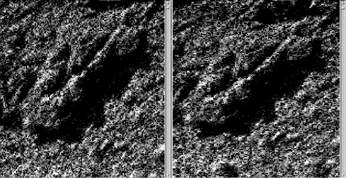
Hello guys !
I currently have some problems in the quality of the images
produced by GDAL/Mapserver.
We are using MapServer to serve raster imagery to NASA Worldwind.
        Our files are in UTM and Worldwind needs WGS84 images so we do
        reprojection on the fly.
        Using this, we can clearly see image quality artefacts between
        Worldwind (using WGS84, no choice) and a custom internal tool
        (showing original data).
I can reproduce the problem using gdalwarp tool using a very
        simple command line :
        gdalwarp -multi -t_srs EPSG:4326 -srcnodata 0 -dstnodata 0 -r
        near %FileSrc%/*_p_*8bit.tif %FileDest%
You can see the result on
        http://benoit.andrieu.free.fr/mapserver/Clipboard02.png : on the
        right, the original image and on the left, the resulting output.
I suspect that using some others settings, I could improve the
        quality on gdalwarp's output in a first time and on mapserver's
        output in a second time but I don't know where to start...
So if anyone could help or suggest anything, he will be welcome !!!
Thanks in advance,
Benoît
        ------------------------------------------------------------------------

        _______________________________________________
        mapserver-users mailing list
        mapserver-users@lists.osgeo.org
        http://lists.osgeo.org/mailman/listinfo/mapserver-users

    ------------------------------------------------------------------------

    _______________________________________________
    mapserver-users mailing list
    mapserver-users@lists.osgeo.org
    http://lists.osgeo.org/mailman/listinfo/mapserver-users


------------------------------------------------------------------------

_______________________________________________
mapserver-users mailing list
mapserver-users@lists.osgeo.org
http://lists.osgeo.org/mailman/listinfo/mapserver-users
_______________________________________________
mapserver-users mailing list
mapserver-users@lists.osgeo.org
http://lists.osgeo.org/mailman/listinfo/mapserver-users