No, neither maxsize nor partials works. I guess that's just the way QGIS
requests large WMS-images.
There is a "tile_metatile_level" configuration directive that should
solve this problem:
https://mapserver.org/output/tile_mode.html

but it does not seem to work for WMS layers.
So I used the underlying PostGIS layer in QGIS, and that works OK, of
course. Not sure if this is a bug in MapServer, though.
Thanks for your help,

Jan

On 10/16/2019 5:55 PM, Rahkonen Jukka (MML) wrote:
Hi,
Print composer is probably making tiled requests from WMS. That is
compulsory for any bigger maps because the default maxsize on the
Mapserver side is 2048x2048 pixels
https://mapserver.org/uk/mapfile/map.html. It is easy to increase the
maxsize but I do not know if print composer as a client can be aware
of that.
Partials FALSE may help, but based on the screenshot it is possible
that print composer is making requests with some overlap.
-Jukka Rahkonen-
*Lähettäjä:*mapserver-users <mapserver-users-boun...@lists.osgeo.org>
*Puolesta *Travis Kirstine
*Lähetetty:* keskiviikko 16. lokakuuta 2019 18.24
*Vastaanottaja:* Jan Hartmann <j.l.h.hartm...@uva.nl>
*Kopio:* MapServer-users <mapserver-users@lists.osgeo.org>
*Aihe:* Re: [mapserver-users] Doubling of labels on high resolution maps

There are a few options you could add to your label but I would start with

MINDISTANCE 200

PARTIALS FALSE

See

https://mapserver.org/mapfile/label.html
On Wed, 16 Oct 2019 at 10:37, Jan Hartmann <j.l.h.hartm...@uva.nl
<mailto:j.l.h.hartm...@uva.nl>> wrote:
Hi,
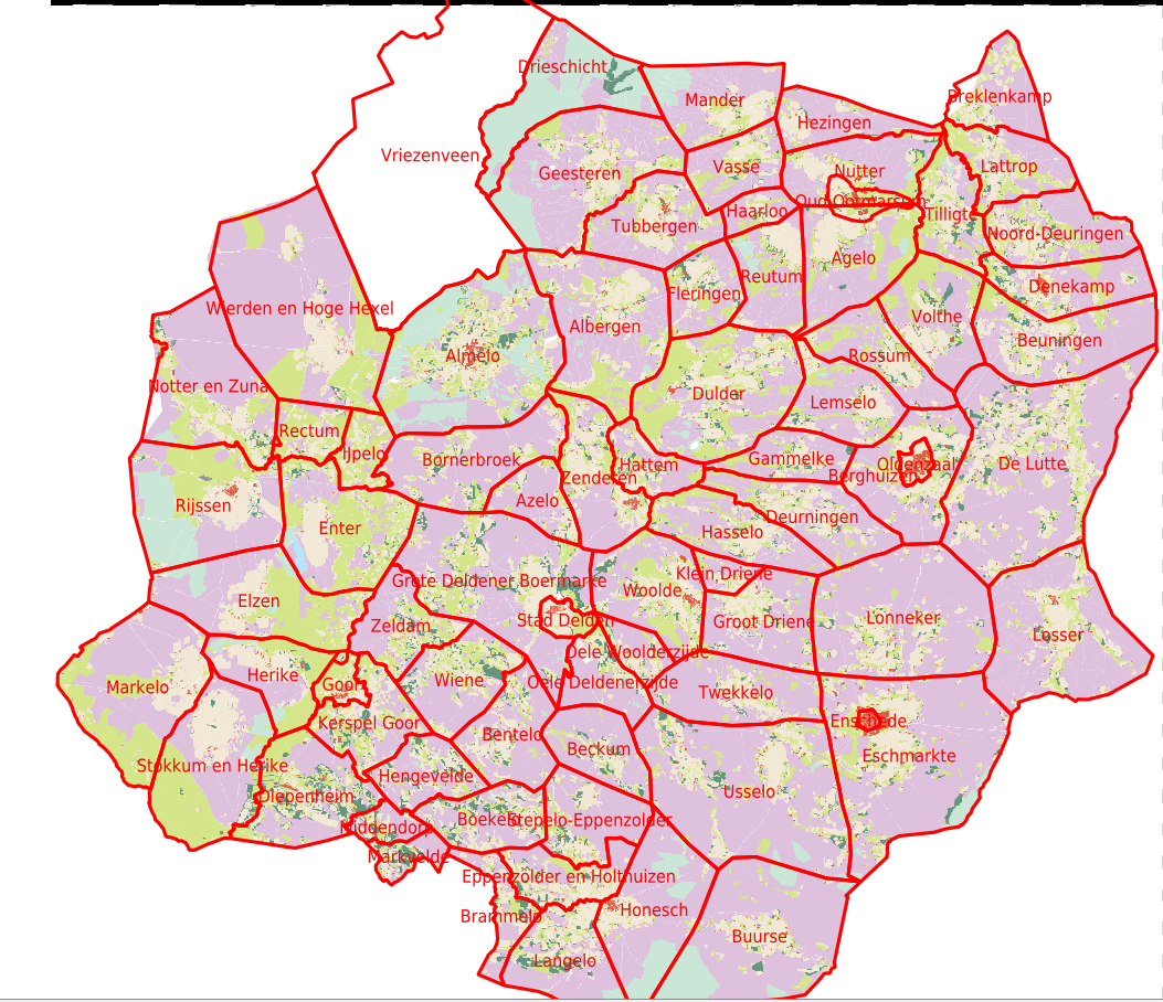
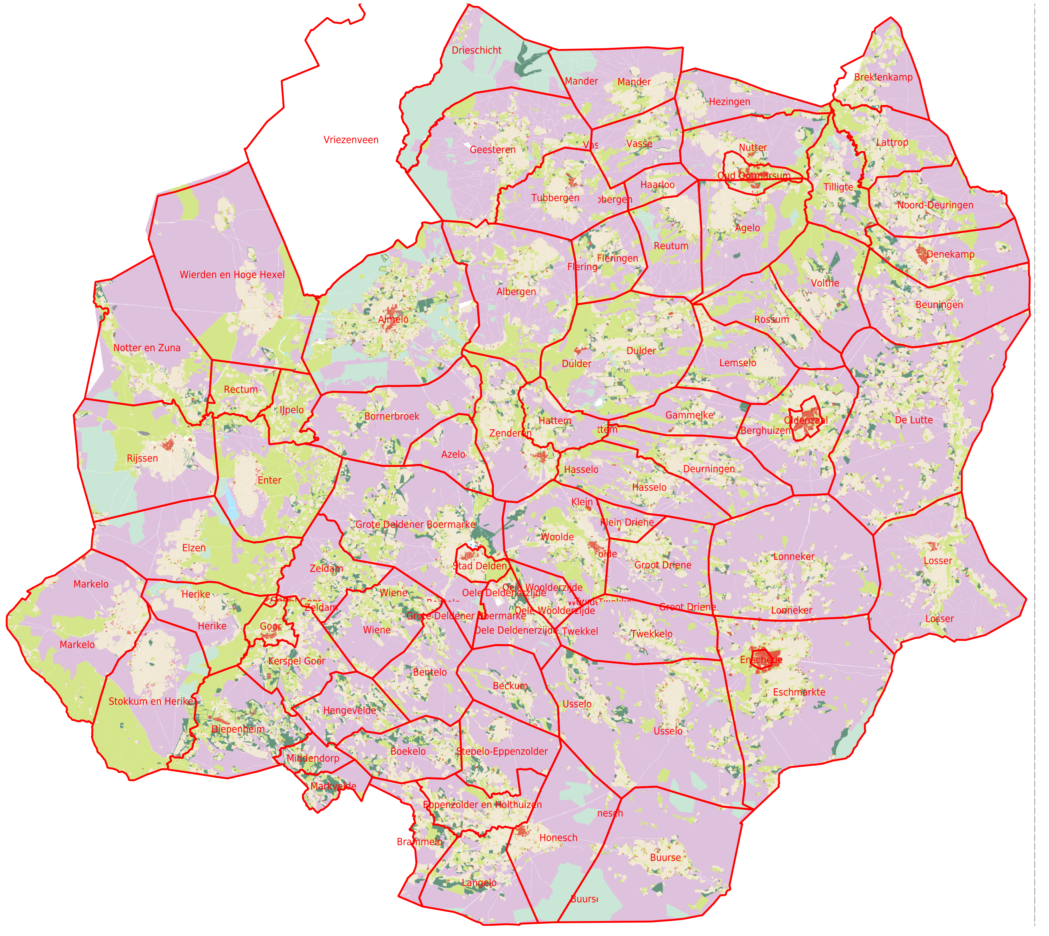
I'm trying to generate high resolution print maps with QGIS, based
on a MapServer WMS layer. When displayed in the regular QGIS
application with 72dpi, all looks fine. When using the Print
Composer based on the same Mapfile, but with 300dpi, some labels
are duplicated (not all). Some duplicates are clipped. The two
versions can be seen here:
https://maps.hisgis.nl/marken_072dpi.png
https://maps.hisgis.nl/marken_300dpi.png
Below the Mapfile. Any idea what goes wrong here?
Jan
map
name Markegrenzen
web
metadata
"wms_title" "Markegrenzen"
"wms_srs" "EPSG:28992 EPSG:3857"
"wms_extent" "13000 301000 279000 620000"
"wms_enable_request" "*"
end
end
extent 13000 301000 279000 620000
units meters
size 400 400
resolution 300
defresolution 72
projection
"init=epsg:28992"
end
z
layer
name Markegrenzen
status on
type polygon
connectiontype postgis
connection "dbname=ov options='-c search_path=horigheid,public'"
data " the_geom from (
select gid,the_geom,naam from markegrenzen
) as foo using unique gid using srid=28992
"
labelitem "naam"
class
style
outlinecolor 255 0 0
width 1
end
label
color 255 0 0
size 4
end
end
end
end
_______________________________________________
mapserver-users mailing list
mapserver-users@lists.osgeo.org
<mailto:mapserver-users@lists.osgeo.org>
https://lists.osgeo.org/mailman/listinfo/mapserver-users
_______________________________________________
mapserver-users mailing list
mapserver-users@lists.osgeo.org
https://lists.osgeo.org/mailman/listinfo/mapserver-users