Dear Lauta Simon

Please see the following link for help concerning GEarthView plugin:
https://github.com/geodrinx/gearthview/issues/1
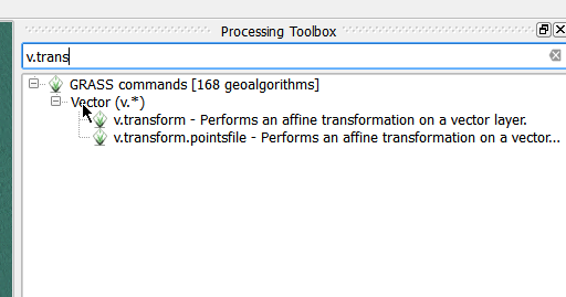
Kindest regards

Evanilton

2015-08-11 6:10 GMT+01:00 <qgis-user-requ...@lists.osgeo.org>:

> Send Qgis-user mailing list submissions to
>         qgis-user@lists.osgeo.org
>
> To subscribe or unsubscribe via the World Wide Web, visit
>         http://lists.osgeo.org/mailman/listinfo/qgis-user
> or, via email, send a message with subject or body 'help' to
>         qgis-user-requ...@lists.osgeo.org
>
> You can reach the person managing the list at
>         qgis-user-ow...@lists.osgeo.org
>
> When replying, please edit your Subject line so it is more specific
> than "Re: Contents of Qgis-user digest..."
>
>
> Today's Topics:
>
>    1. GEarthView (Lauta Simon)
>    2. Re: Georeferencing Vector Files (Springfield Harrison)
>    3. Re: Georeferencing Vector Files (Springfield Harrison)
>    4. Re: Georeferencing Vector Files (Springfield Harrison)
>    5. Re: Georeferencing Vector Files (Nathan Woodrow)
>
>
> ----------------------------------------------------------------------
>
> Message: 1
> Date: Mon, 10 Aug 2015 16:47:40 -0300
> From: Lauta Simon <lauta....@gmail.com>
> To: qgis-user@lists.osgeo.org
> Subject: [Qgis-user] GEarthView
> Message-ID:
>         <CAJy2DA7Z5E_95MR2jbo35FprAFev=
> ylwa-qavj_hoothnds...@mail.gmail.com>
> Content-Type: text/plain; charset="utf-8"
>
> Hi, I have a problem with the installation of GEarthView. The complement is
> broken, and the program said "No module named sope.interface". I manually
> download the complement but I don't know how install it?
> Can you help me? Thank you!
>
>
> Lautaro
> -------------- next part --------------
> An HTML attachment was scrubbed...
> URL: <
> http://lists.osgeo.org/pipermail/qgis-user/attachments/20150810/09d50f2d/attachment-0001.html
> >
>
> ------------------------------
>
> Message: 2
> Date: Mon, 10 Aug 2015 12:49:32 -0700
> From: Springfield Harrison <stellar...@gmail.com>
> To: Paolo Cavallini <cavall...@faunalia.it>,    Thomas Colley
>         <it...@neath-porttalbot.gov.uk>
> Cc: qgis-user <qgis-user@lists.osgeo.org>, t...@wildintellect.com
> Subject: Re: [Qgis-user] Georeferencing Vector Files
> Message-ID: <55c90052.aa3c460a.7d94.5...@mx.google.com>
> Content-Type: text/plain; charset="us-ascii"
>
> An HTML attachment was scrubbed...
> URL: <
> http://lists.osgeo.org/pipermail/qgis-user/attachments/20150810/a7a0ee95/attachment-0001.html
> >
>
> ------------------------------
>
> Message: 3
> Date: Mon, 10 Aug 2015 14:41:13 -0700
> From: Springfield Harrison <stellar...@gmail.com>
> To: Thomas Colley <it...@neath-porttalbot.gov.uk>,
>         "t...@wildintellect.com" <t...@wildintellect.com>,      qgis-user
>         <qgis-user@lists.osgeo.org>
> Subject: Re: [Qgis-user] Georeferencing Vector Files
> Message-ID: <55c91a81.28b1420a.2a65b.ffffb...@mx.google.com>
> Content-Type: text/plain; charset="us-ascii"; format=flowed
>
> Hi Tom,
>
>          I must be missing something.  Can't see this in the
> Processing Toolbx - where do I look?  Would it be missing in my
> version (W7, QGIS2.10.1)?
>
>                  Thanks, cheers . . . .   Spring Harrison
>
>
>
> At 10-08-2015 03:27 Monday, Thomas Colley wrote:
> >Hi
> >
> >I did this recently using the GRASS command v.transform.pointsfile
> >from the Processing Toolbox in QGIS. No need to actually go into
> >GRASS and create mapsets.
> >
> >This worked really well for me for unreferenced DXFs. If you need
> >any more info let me know.
> >
> >Cheers
> >
> >Tom
> >
> >
> >-----Original Message-----
> >From: qgis-user-boun...@lists.osgeo.org
> >[mailto:qgis-user-boun...@lists.osgeo.org] On Behalf Of Springfield
> Harrison
> >Sent: 09 August 2015 19:51
> >To: t...@wildintellect.com; qgis-user
> >Subject: Re: [Qgis-user] Georeferencing Vector Files
> >
> >Ok, thanks. I'm installing QGIS on W7 yet again, trying to achieve
> >better functionality. That is a challenge in itself, prone to wrong
> >turns. Hopefully the VectorGeoref will then work.
> >
> >This whole install process is a real piece of work . . . . .
> >
> >                 Thanks again, cheers . . . .  Spring Harrison
> >
> >
> >
> >At 09-08-2015 10:52 Sunday, Alex Mandel wrote:
> > >ogr2ogr is a command line tool, Terminal/Shell on Mac/Linux, OSGeo4w
> > >shell on Windows.
> > >
> > >Supposedly the Vector Georef plugin wraps this functionality into QGIS.
> > >
> > >-Alex
> > >
> > >On 08/09/2015 12:08 AM, Springfield Harrison wrote:
> > > > Right, but where is org2org? I've looked in many menu items, help,
> etc.
> > > > to no avail.
> > > >
> > > > Sorry to be a bit thick but how is it accessed?
> > > >
> > > > Also, GRASS has v.transform and v.rectify but starting a new GRASS
> > > > mapset fails with no reason given.
> > > >
> > > > Great tools but why are they so hard to access?
> > > >
> > > >       Thanks, cheers . . . . Spring Harrison
> > > >
> > > >
> > > >
> > > > At 08-08-2015 23:20 Saturday, Alex Mandel wrote:
> > > >> Save the whole map, it's on the main File menu, it just saves the
> > > >> current canvas.
> > > >>
> > > >> If you already have a list of gcps you can skip that step
> > > >>
> > > >> Example
> > > >>
> > > http://gis.stackexchange.com/questions/107298/process-to-georeference-
> > > corners-of-vector-file
> > > >>
> > > >>
> > > >>
> > > >> Enjoy,
> > > >> Alex
> > > >>
> > > >> On 08/08/2015 07:26 PM, Springfield Harrison wrote:
> > > >> > Hello Alex,
> > > >> >
> > > >> >      Further to my last, for Vector Save As, I couldn't find any
> > > >> > option to save it as a raster file. Is there some other place to
> look?
> > > >> >
> > > >> >              Thanks again, Cheers . . . . . . . . Spring
> > > >> > Harrison
> > > >> >
> > > >> >
> > > >> >
> > > >> >
> > > >> > At 08-08-2015 12:07 Saturday, Alex Mandel wrote:
> > > >> >> On 08/06/2015 11:08 AM, Springfield Harrison wrote:
> > > >> >> > Hello All,
> > > >> >> >
> > > >> >> > Is there a tool/plugin for georeferencing vector files to an
> > > >> existing
> > > >> >> > projected layer?
> > > >> >> >
> > > >> >> > I'm intending to bring in property survey drawings that have
> > > >> >> > only
> > > >> local
> > > >> >> > coordinates but projected coordinates (UTM) are available for
> > > >> >> > some
> > > >> >> corners.
> > > >> >> >
> > > >> >> > Thank you . . . .
> > > >> >> >
> > > >> >> > Cheers . . . . . Springfield Harrison Samsung Tab 4
> > > >> >> >
> > > >> >> >
> > > >> >>
> > > >> >> My trick, is convert the vector an image in QGIS (Save Image)
> > > >> >> Georeference the image, saving the control point list out to a
> file.
> > > >> >> You can then use these control points (gcps) with ogr2ogr
> > to transform
> > > >> >> the original vector.
> > > >> >>
> > > >> >> -Alex
> > > >> >
> > > >> > _______________________________________________
> > > >> > Qgis-user mailing list
> > > >> > Qgis-user@lists.osgeo.org
> > > >> > http://lists.osgeo.org/mailman/listinfo/qgis-user
> > > >
> >
> >_______________________________________________
> >Qgis-user mailing list
> >Qgis-user@lists.osgeo.org
> >http://lists.osgeo.org/mailman/listinfo/qgis-user
>
>
>
> ------------------------------
>
> Message: 4
> Date: Mon, 10 Aug 2015 22:06:01 -0700
> From: Springfield Harrison <stellar...@gmail.com>
> To: Thomas Colley <it...@neath-porttalbot.gov.uk>,
>         "t...@wildintellect.com" <t...@wildintellect.com>,      qgis-user
>         <qgis-user@lists.osgeo.org>
> Subject: Re: [Qgis-user] Georeferencing Vector Files
> Message-ID: <55c982bf.43e8440a.30b0b.2...@mx.google.com>
> Content-Type: text/plain; charset="us-ascii"; format=flowed
>
> Hello Thomas,
>
>          I have hunted high and low in the Processing Toolbox and
> cannot find any place there to enter command line instructions.  They
> all seem to be pre-coded tools, nothing with a command line.  Should
> I be looking somewhere else?
>
>                  Thank you again, Cheers . . . . . . . . Spring Harrison
>
>
>
> At 10-08-2015 03:27 Monday, Thomas Colley wrote:
> >Hi
> >
> >I did this recently using the GRASS command v.transform.pointsfile
> >from the Processing Toolbox in QGIS. No need to actually go into
> >GRASS and create mapsets.
> >
> >This worked really well for me for unreferenced DXFs. If you need
> >any more info let me know.
> >
> >Cheers
> >
> >Tom
> >
> >
> >-----Original Message-----
> >From: qgis-user-boun...@lists.osgeo.org
> >[mailto:qgis-user-boun...@lists.osgeo.org] On Behalf Of Springfield
> Harrison
> >Sent: 09 August 2015 19:51
> >To: t...@wildintellect.com; qgis-user
> >Subject: Re: [Qgis-user] Georeferencing Vector Files
> >
> >Ok, thanks. I'm installing QGIS on W7 yet again, trying to achieve
> >better functionality. That is a challenge in itself, prone to wrong
> >turns. Hopefully the VectorGeoref will then work.
> >
> >This whole install process is a real piece of work . . . . .
> >
> >                 Thanks again, cheers . . . .  Spring Harrison
> >
> >
> >
> >At 09-08-2015 10:52 Sunday, Alex Mandel wrote:
> > >ogr2ogr is a command line tool, Terminal/Shell on Mac/Linux, OSGeo4w
> > >shell on Windows.
> > >
> > >Supposedly the Vector Georef plugin wraps this functionality into QGIS.
> > >
> > >-Alex
> > >
> > >On 08/09/2015 12:08 AM, Springfield Harrison wrote:
> > > > Right, but where is org2org? I've looked in many menu items, help,
> etc.
> > > > to no avail.
> > > >
> > > > Sorry to be a bit thick but how is it accessed?
> > > >
> > > > Also, GRASS has v.transform and v.rectify but starting a new GRASS
> > > > mapset fails with no reason given.
> > > >
> > > > Great tools but why are they so hard to access?
> > > >
> > > >       Thanks, cheers . . . . Spring Harrison
> > > >
> > > >
> > > >
> > > > At 08-08-2015 23:20 Saturday, Alex Mandel wrote:
> > > >> Save the whole map, it's on the main File menu, it just saves the
> > > >> current canvas.
> > > >>
> > > >> If you already have a list of gcps you can skip that step
> > > >>
> > > >> Example
> > > >>
> > > http://gis.stackexchange.com/questions/107298/process-to-georeference-
> > > corners-of-vector-file
> > > >>
> > > >>
> > > >>
> > > >> Enjoy,
> > > >> Alex
> > > >>
> > > >> On 08/08/2015 07:26 PM, Springfield Harrison wrote:
> > > >> > Hello Alex,
> > > >> >
> > > >> >      Further to my last, for Vector Save As, I couldn't find any
> > > >> > option to save it as a raster file. Is there some other place to
> look?
> > > >> >
> > > >> >              Thanks again, Cheers . . . . . . . . Spring
> > > >> > Harrison
> > > >> >
> > > >> >
> > > >> >
> > > >> >
> > > >> > At 08-08-2015 12:07 Saturday, Alex Mandel wrote:
> > > >> >> On 08/06/2015 11:08 AM, Springfield Harrison wrote:
> > > >> >> > Hello All,
> > > >> >> >
> > > >> >> > Is there a tool/plugin for georeferencing vector files to an
> > > >> existing
> > > >> >> > projected layer?
> > > >> >> >
> > > >> >> > I'm intending to bring in property survey drawings that have
> > > >> >> > only
> > > >> local
> > > >> >> > coordinates but projected coordinates (UTM) are available for
> > > >> >> > some
> > > >> >> corners.
> > > >> >> >
> > > >> >> > Thank you . . . .
> > > >> >> >
> > > >> >> > Cheers . . . . . Springfield Harrison Samsung Tab 4
> > > >> >> >
> > > >> >> >
> > > >> >>
> > > >> >> My trick, is convert the vector an image in QGIS (Save Image)
> > > >> >> Georeference the image, saving the control point list out to a
> file.
> > > >> >> You can then use these control points (gcps) with ogr2ogr
> > to transform
> > > >> >> the original vector.
> > > >> >>
> > > >> >> -Alex
> > > >> >
> > > >> > _______________________________________________
> > > >> > Qgis-user mailing list
> > > >> > Qgis-user@lists.osgeo.org
> > > >> > http://lists.osgeo.org/mailman/listinfo/qgis-user
> > > >
> >
> >_______________________________________________
> >Qgis-user mailing list
> >Qgis-user@lists.osgeo.org
> >http://lists.osgeo.org/mailman/listinfo/qgis-user
>
>
>
> ------------------------------
>
> Message: 5
> Date: Tue, 11 Aug 2015 15:10:05 +1000
> From: Nathan Woodrow <madman...@gmail.com>
> To: Springfield Harrison <stellar...@gmail.com>
> Cc: qgis-user <qgis-user@lists.osgeo.org>,      Thomas Colley
>         <it...@neath-porttalbot.gov.uk>,        "t...@wildintellect.com"
>         <t...@wildintellect.com>
> Subject: Re: [Qgis-user] Georeferencing Vector Files
> Message-ID:
>         <CAAi8Yg9xoE2ehBSN8dtoB1VkMUsuxwuYdx_mT1_zSm=
> faeg...@mail.gmail.com>
> Content-Type: text/plain; charset="utf-8"
>
> Hey,
>
> Did you do a search in the top part of the dock:
>
> [image: Inline image 1]
>
> Regards,
> Nathan
>
> On Tue, Aug 11, 2015 at 3:06 PM, Springfield Harrison <
> stellar...@gmail.com>
> wrote:
>
> > Hello Thomas,
> >
> >         I have hunted high and low in the Processing Toolbox and cannot
> > find any place there to enter command line instructions.  They all seem
> to
> > be pre-coded tools, nothing with a command line.  Should I be looking
> > somewhere else?
> >
> >                 Thank you again, Cheers . . . . . . . . Spring Harrison
> >
> >
> >
> > At 10-08-2015 03:27 Monday, Thomas Colley wrote:
> >
> >> Hi
> >>
> >> I did this recently using the GRASS command v.transform.pointsfile from
> >> the Processing Toolbox in QGIS. No need to actually go into GRASS and
> >> create mapsets.
> >>
> >> This worked really well for me for unreferenced DXFs. If you need any
> >> more info let me know.
> >>
> >> Cheers
> >>
> >> Tom
> >>
> >>
> >> -----Original Message-----
> >> From: qgis-user-boun...@lists.osgeo.org [mailto:
> >> qgis-user-boun...@lists.osgeo.org] On Behalf Of Springfield Harrison
> >> Sent: 09 August 2015 19:51
> >> To: t...@wildintellect.com; qgis-user
> >> Subject: Re: [Qgis-user] Georeferencing Vector Files
> >>
> >> Ok, thanks. I'm installing QGIS on W7 yet again, trying to achieve
> better
> >> functionality. That is a challenge in itself, prone to wrong turns.
> >> Hopefully the VectorGeoref will then work.
> >>
> >> This whole install process is a real piece of work . . . . .
> >>
> >>                 Thanks again, cheers . . . .  Spring Harrison
> >>
> >>
> >>
> >> At 09-08-2015 10:52 Sunday, Alex Mandel wrote:
> >> >ogr2ogr is a command line tool, Terminal/Shell on Mac/Linux, OSGeo4w
> >> >shell on Windows.
> >> >
> >> >Supposedly the Vector Georef plugin wraps this functionality into QGIS.
> >> >
> >> >-Alex
> >> >
> >> >On 08/09/2015 12:08 AM, Springfield Harrison wrote:
> >> > > Right, but where is org2org? I've looked in many menu items, help,
> >> etc.
> >> > > to no avail.
> >> > >
> >> > > Sorry to be a bit thick but how is it accessed?
> >> > >
> >> > > Also, GRASS has v.transform and v.rectify but starting a new GRASS
> >> > > mapset fails with no reason given.
> >> > >
> >> > > Great tools but why are they so hard to access?
> >> > >
> >> > >       Thanks, cheers . . . . Spring Harrison
> >> > >
> >> > >
> >> > >
> >> > > At 08-08-2015 23:20 Saturday, Alex Mandel wrote:
> >> > >> Save the whole map, it's on the main File menu, it just saves the
> >> > >> current canvas.
> >> > >>
> >> > >> If you already have a list of gcps you can skip that step
> >> > >>
> >> > >> Example
> >> > >>
> >> >
> http://gis.stackexchange.com/questions/107298/process-to-georeference-
> >> > corners-of-vector-file
> >> > >>
> >> > >>
> >> > >>
> >> > >> Enjoy,
> >> > >> Alex
> >> > >>
> >> > >> On 08/08/2015 07:26 PM, Springfield Harrison wrote:
> >> > >> > Hello Alex,
> >> > >> >
> >> > >> >      Further to my last, for Vector Save As, I couldn't find any
> >> > >> > option to save it as a raster file. Is there some other place to
> >> look?
> >> > >> >
> >> > >> >              Thanks again, Cheers . . . . . . . . Spring
> >> > >> > Harrison
> >> > >> >
> >> > >> >
> >> > >> >
> >> > >> >
> >> > >> > At 08-08-2015 12:07 Saturday, Alex Mandel wrote:
> >> > >> >> On 08/06/2015 11:08 AM, Springfield Harrison wrote:
> >> > >> >> > Hello All,
> >> > >> >> >
> >> > >> >> > Is there a tool/plugin for georeferencing vector files to an
> >> > >> existing
> >> > >> >> > projected layer?
> >> > >> >> >
> >> > >> >> > I'm intending to bring in property survey drawings that have
> >> > >> >> > only
> >> > >> local
> >> > >> >> > coordinates but projected coordinates (UTM) are available for
> >> > >> >> > some
> >> > >> >> corners.
> >> > >> >> >
> >> > >> >> > Thank you . . . .
> >> > >> >> >
> >> > >> >> > Cheers . . . . . Springfield Harrison Samsung Tab 4
> >> > >> >> >
> >> > >> >> >
> >> > >> >>
> >> > >> >> My trick, is convert the vector an image in QGIS (Save Image)
> >> > >> >> Georeference the image, saving the control point list out to a
> >> file.
> >> > >> >> You can then use these control points (gcps) with ogr2ogr to
> >> transform
> >> > >> >> the original vector.
> >> > >> >>
> >> > >> >> -Alex
> >> > >> >
> >> > >> > _______________________________________________
> >> > >> > Qgis-user mailing list
> >> > >> > Qgis-user@lists.osgeo.org
> >> > >> > http://lists.osgeo.org/mailman/listinfo/qgis-user
> >> > >
> >>
> >> _______________________________________________
> >> Qgis-user mailing list
> >> Qgis-user@lists.osgeo.org
> >> http://lists.osgeo.org/mailman/listinfo/qgis-user
> >>
> >
> > _______________________________________________
> > Qgis-user mailing list
> > Qgis-user@lists.osgeo.org
> > http://lists.osgeo.org/mailman/listinfo/qgis-user
> >
> -------------- next part --------------
> An HTML attachment was scrubbed...
> URL: <
> http://lists.osgeo.org/pipermail/qgis-user/attachments/20150811/49743184/attachment.html
> >
> -------------- next part --------------
> A non-text attachment was scrubbed...
> Name: image.png
> Type: image/png
> Size: 21090 bytes
> Desc: not available
> URL: <
> http://lists.osgeo.org/pipermail/qgis-user/attachments/20150811/49743184/attachment.png
> >
>
> ------------------------------
>
> _______________________________________________
> Qgis-user mailing list
> Qgis-user@lists.osgeo.org
> http://lists.osgeo.org/mailman/listinfo/qgis-user
>
> End of Qgis-user Digest, Vol 114, Issue 16
> ******************************************
>
_______________________________________________
Qgis-user mailing list
Qgis-user@lists.osgeo.org
http://lists.osgeo.org/mailman/listinfo/qgis-user