While I am on the topic of minor bugs, I think there might be something
'loose' wrt the coding of the colour for wall point altitudes and 'point
station-names'.
In the examples below I have a more or less black and white layout, but I
have made the survey stations stand out as follows;
symbol-colour point station [54 7 60] # affects +s, flag
symbols and station text
symbol-colour point station-name [54 7 60] # affects
station-names (and sometimes wall altitude . 's)
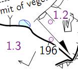
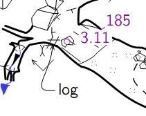
The image above is as it should be, station symbols and names are coloured
and the wall altitude is black.
However in the same output, there are usually a few wall altitudes that take
on the station colour as above.
It only happens when the 'symbol-colour point station-name' is defined, so I
guess that is a clue.
It usually happens when the altitude is near a station-name, but not always,
as you can see in the example above. The effect can be made to go away
sometimes by moving either the station-name or the altitude, so it is
perhaps related to the proximity, or drawing order, although in the example
above moving the "3.11" down near the word "log" does not change the effect
on the "185" altitude.
Anyone else notice effects like this, or have suggestions as to why it might
be happening.
Thanks
Bruce
-------------- next part --------------
An HTML attachment was scrubbed...
URL:
<http://mailman.speleo.sk/pipermail/therion/attachments/20140103/5a828235/attachment.html>
-------------- next part --------------
A non-text attachment was scrubbed...
Name: image001.jpg
Type: image/jpeg
Size: 6183 bytes
Desc: image001.jpg
URL:
<http://mailman.speleo.sk/pipermail/therion/attachments/20140103/5a828235/attachment.jpg>
-------------- next part --------------
A non-text attachment was scrubbed...
Name: image002.jpg
Type: image/jpeg
Size: 8421 bytes
Desc: image002.jpg
URL:
<http://mailman.speleo.sk/pipermail/therion/attachments/20140103/5a828235/attachment-0001.jpg>