On Thu, 17 Dec 2020 at 12:43, Joseph Eisenberg <joseph.eisenb...@gmail.com>
wrote:
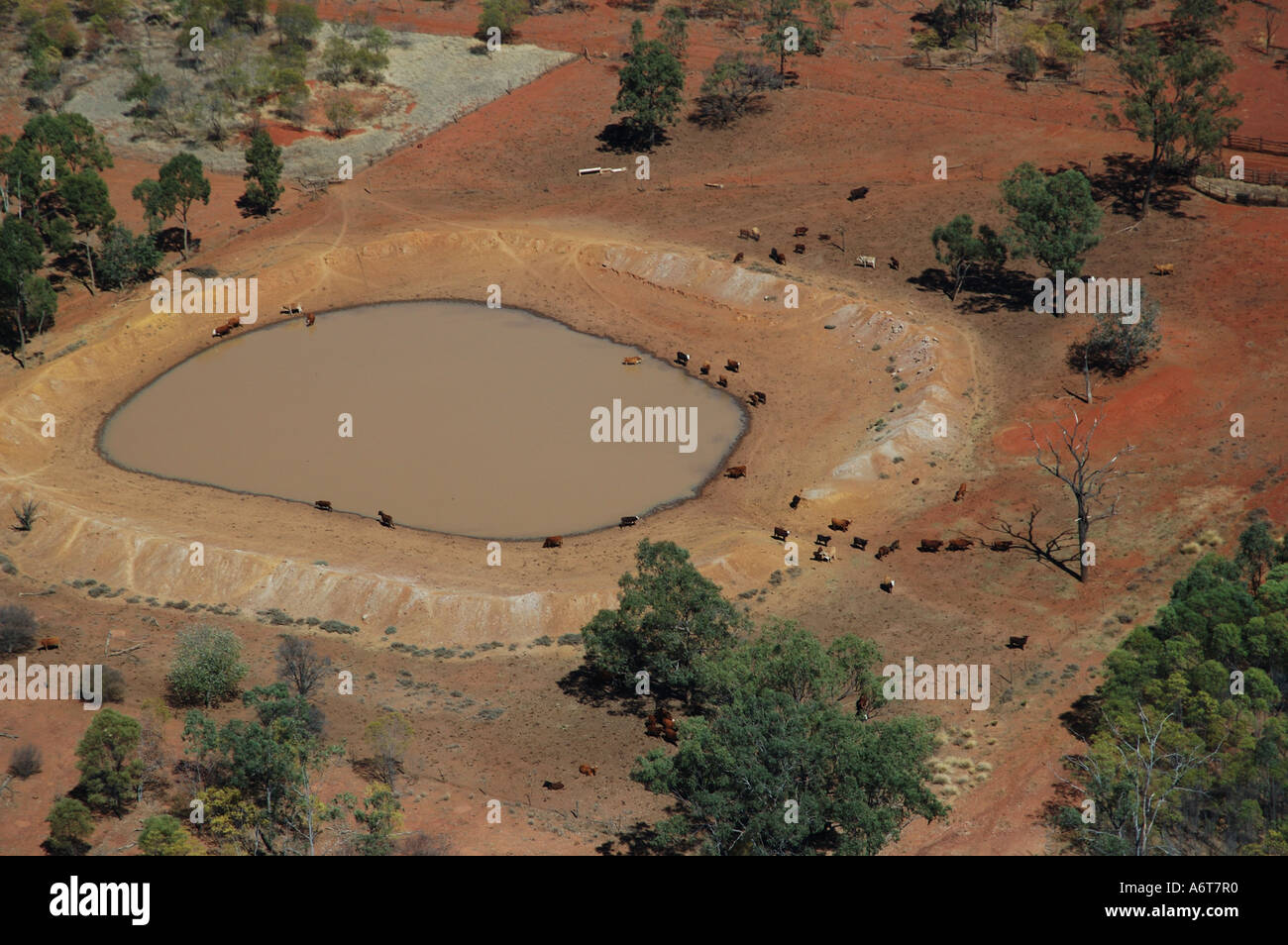
> That example certainly looks like a landuse=basin or water=basin feature
> with basin=retention
>

Maybe? But there's an awful lot of them tagged as reservoirs!

Thanks

Graeme

>
> On Wed, Dec 16, 2020 at 6:23 PM Graeme Fitzpatrick <graemefi...@gmail.com>
> wrote:
>
>> In an Australian context, the most common are known as Turkey's Nest
>> dams, because they're mounded up above the ground eg
>>
>> https://c8.alamy.com/comp/A6T7R0/turkey-nest-dam-on-outback-cattle-station-queensland-australia-A6T7R0.jpg
>>
>> For a full explanation:
>> https://www.agric.wa.gov.au/water-management/excavated-tanks-farm-dams
>>
>> Thanks
>>
>> Graeme
>>
>>
>> On Thu, 17 Dec 2020 at 11:53, Joseph Guillaume <josephguilla...@gmail.com>
>> wrote:
>>
>>> That Wikipedia page is right.
>>> The artificial grading mostly involves creating an (earthen) dam wall
>>> (which is often also mapped), and the purpose is generally retention of
>>> water rather than infiltration or detention, which is why the distinction
>>> between reservoir and basin isn't clear cut to me.
>>>
>>> I'm having trouble thinking of it as a basin, but it does seem like this
>>> is the intended tag. Thanks!
>>>
>>>
>>>
>>> On Thu, 17 Dec 2020, 12:29 pm Joseph Eisenberg, <
>>> joseph.eisenb...@gmail.com> wrote:
>>>
>>>> What is a farm dam in this context? We don't have that term in American
>>>> English.
>>>>
>>>> Is this perhaps an example of landuse=basin (or if you prefer
>>>> water=basin) with basin=detention or basin=infiltration?
>>>>
>>>> https://wiki.openstreetmap.org/wiki/Tag:landuse%3Dbasin
>>>>
>>>> https://en.wikipedia.org/wiki/Dam_(agricultural_reservoir)
>>>>
>>>> -- Joseph Eisenberg
>>>>
>>>> On Wed, Dec 16, 2020 at 1:29 PM Joseph Guillaume <
>>>> josephguilla...@gmail.com> wrote:
>>>>
>>>>> This discussion has convinced me not to use landuse=reservoir.
>>>>>
>>>>> It sounds like the only benefit is its historical use, whereas I've
>>>>> personally seen benefits of the natural=water approach.
>>>>>
>>>>> I've mapped quite a number of farm dams as natural=water without being
>>>>> sure what subtag to use.
>>>>> I now think that's because there isn't an appropriate subtag. I
>>>>> definitely don't want to tag it as a pond. While a farm dam is
>>>>> structurally
>>>>> and functionally a reservoir, there are clear differences with large
>>>>> reservoirs.
>>>>>
>>>>> Already now, farm dams tend to be mapped more prominently than I'd
>>>>> expect. The dominant feature of these grazing landscapes is fencing, and
>>>>> I'd therefore expect farm dams to appear on a similar scale to fences.
>>>>> water=reservoir and landuse=reservoir wouldn't do that.
>>>>>
>>>>> One of the things I love about OSM is the ability to map
>>>>> incrementally, which by definition results in incomplete, lower quality
>>>>> maps that are constantly improving. If the priority was a high quality
>>>>> map,
>>>>> we'd map systematically (like Missing maps, but for everything that will
>>>>> appear on a render) and not release an area until it was done. I wouldn't
>>>>> be mapping.
>>>>>
>>>>>
>>>>> On Thu, 17 Dec 2020, 1:26 am Tomas Straupis, <tomasstrau...@gmail.com>
>>>>> wrote:
>>>>>
>>>>>> 2020-12-16, tr, 16:01 Mateusz Konieczny rašė:
>>>>>> >
>>>>>> https://wiki.openstreetmap.org/wiki/Tag:landuse%3Dreservoir#water.3Dreservoir
>>>>>> > (just added)
>>>>>>
>>>>>>   Thank you. Maybe it is better to discuss here before adding to wiki?
>>>>>>   My arguments on the points you've added:
>>>>>>
>>>>>>   1. Regarding benefit of having a combining level/tag natural=water.
>>>>>> If today you would query all data with natural=water - you will get
>>>>>> not only lakes and reservoirs grouped, but also riverbank polygons
>>>>>> (totally different beast) and micro elements like water=pond. This
>>>>>> could only be partly useful in the largest scale maps and only if you
>>>>>> make very simple maps and for some reason use the same symbolisation
>>>>>> for such different water classes. For example ponds usually have less
>>>>>> complex and less prominent symbolisation because of their size and
>>>>>> importance. Riverbanks would not need polygon labelling, but rather
>>>>>> use river (central) line for label placement. Most of GIS/Cartography
>>>>>> work goes in middle/small scales and it will be impossible to use only
>>>>>> natural=water there, you would have to add "and water not in
>>>>>> ('riverbank', 'pond', ...)". This erodes the benefit of "one tag" and
>>>>>> makes it of the same complexity from coding perspective as original
>>>>>> water scheme.
>>>>>>
>>>>>>   2. Very important disadvantage of water=reservoir from
>>>>>> cartographic/gis perspective: it allows mappers to NOT differentiate
>>>>>> between natural lakes and man made reservoirs. If first point
>>>>>> describes how different classes are USED, this second point is about
>>>>>> how these classes are CAPTURED.
>>>>>>
>>>>>>   Did I miss anything?
>>>>>>
>>>>>> _______________________________________________
>>>>>> Tagging mailing list
>>>>>> Tagging@openstreetmap.org
>>>>>> https://lists.openstreetmap.org/listinfo/tagging
>>>>>>
>>>>> _______________________________________________
>>>>> Tagging mailing list
>>>>> Tagging@openstreetmap.org
>>>>> https://lists.openstreetmap.org/listinfo/tagging
>>>>>
>>>> _______________________________________________
>>>> Tagging mailing list
>>>> Tagging@openstreetmap.org
>>>> https://lists.openstreetmap.org/listinfo/tagging
>>>>
>>> _______________________________________________
>>> Tagging mailing list
>>> Tagging@openstreetmap.org
>>> https://lists.openstreetmap.org/listinfo/tagging
>>>
>> _______________________________________________
>> Tagging mailing list
>> Tagging@openstreetmap.org
>> https://lists.openstreetmap.org/listinfo/tagging
>>
> _______________________________________________
> Tagging mailing list
> Tagging@openstreetmap.org
> https://lists.openstreetmap.org/listinfo/tagging
>
_______________________________________________
Tagging mailing list
Tagging@openstreetmap.org
https://lists.openstreetmap.org/listinfo/tagging