DfT provide separate figures for trunk and primary, but I'm afraid that at
the moment I just count all trunk and primary as primary.
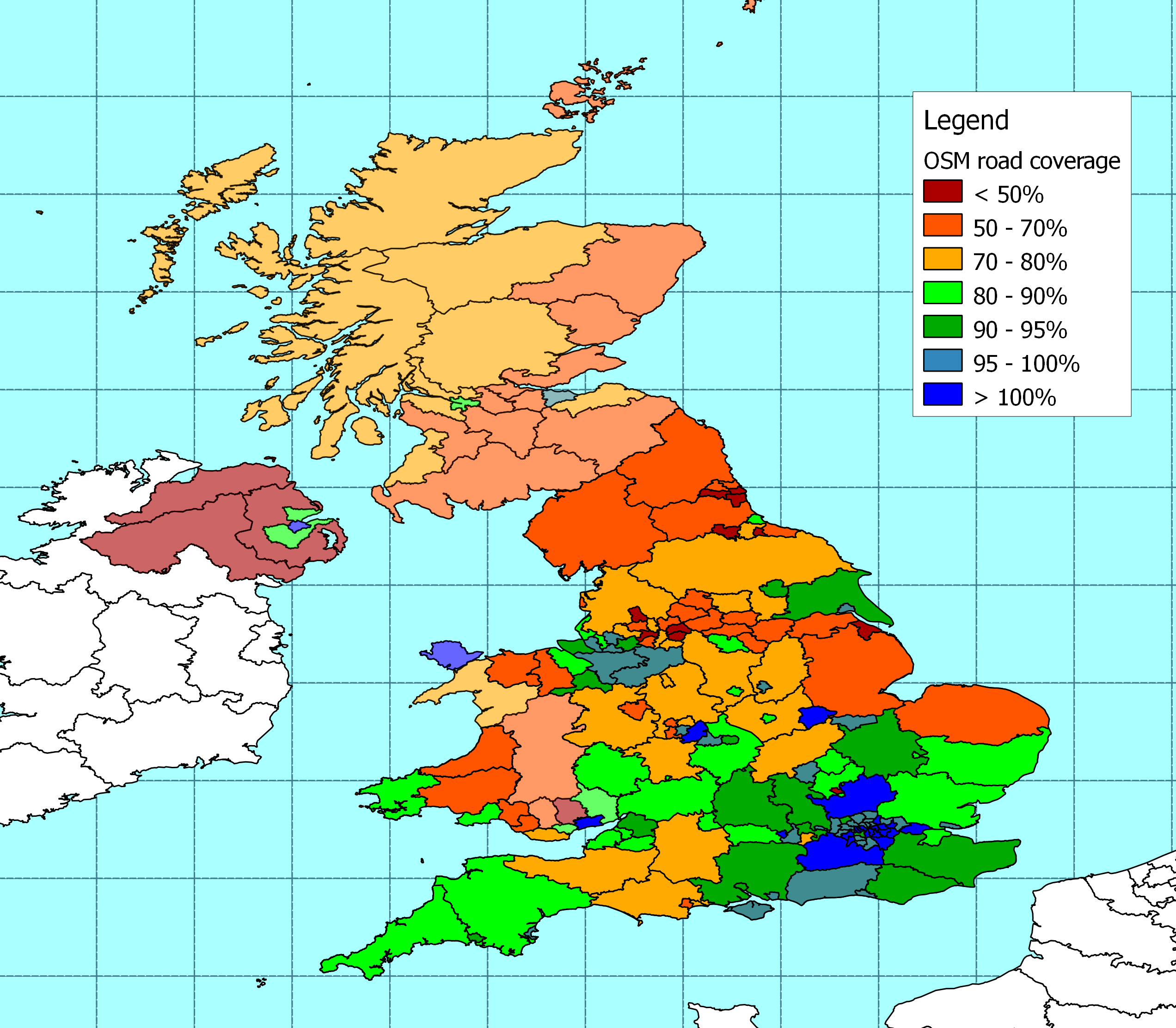
From: Graham Jones [mailto:grahamjones...@googlemail.com]
Sent: 29 March 2010 20:36
To: peter.r...@aligre.co.uk
Cc: talk-gb@openstreetmap.org
Subject: Re: [Talk-GB] OSM coverage


Hi Peter,

Thanks for that - I can see another target now - to turn Hartlepool Blue!


How do 'Trunk' roads fit into yours (and the DfT's) scheme?   Someone
changed the main road into Hartlepool to be 'Trunk' on the basis that it has
green signs, but I have never thought of it as being a significant enough
place to have a Trunk road, although it does have green signs.   Have you
merged trunk and primary?


Regards


Graham.


On 29 March 2010 17:57, Peter Reed <peter.r...@aligre.co.uk> wrote:

It's been three months since I last tried to measure road lengths on OSM
against the Department for Transport statistics, and I thought there might
be some interest in how things are progressing.


At the moment this has only been updated where I already have decent admin
boundaries from OSM. In other words I've updated the figures for all of
England and some bits of Wales.


There are long complicated technical reasons (i.e. typing errors) that mean
the figures for Scotland and the rest of Wales still date from January.


In the updated areas I reckon that the length of roads in the OSM database
has increased by around 2% in the last three months so the overall pattern
of coverage stays much the same.


The DfT reckons that there are about 343,000 km of road in the areas I've
updated - and I reckon 78% of them are on OSM.


The most significant increases have been in: Stoke-on-Trent (43% more
roads), Luton (26%), Bolton (18%), and Redcar & Cleveland (16%).


Another eleven local authority areas have seen the length of roads on OSM
increase by more than 10% (Vale of Glamorgan, Walsall, Poole,
Northumberland, Stockton-on-Tees, Bournemouth, Staffordshire, Dudley, North
East Lincolnshire, Medway and Dorset).


Comparing different road types, it looks as though virtually all major roads
are covered; and about 72% of minor roads.


The actual numbers are:


.         Motorways:  DfT say 6,381 km, OSM contains 5,994 km, plus 1,093 km
of link roads that the DfT tell me they don't count. Those numbers suggest
that the DfT are really counting some roads that are tagged as "motorway
link" in OSM, but not all of them

.         Primary: DfT says 43,356km, OSM contains 42,861km = 99% mapped
(there are variations from authority to authority)

.         Secondary: DfT says 22,625km, OSM contains 22,549 km, = 100%
mapped (there are variations from authority to authority)

.         Tertiary: DfT says 73,878 km, OSM contains 33,547 km = 45% mapped

.         Unclassified / residential: DfT says 196,681 km, OSM contains
161,598 km = 82% mapped


That suggests to me that there is a tendency to tag roads that DFT consider
tertiary as unclassified / residential. No surprise there.


I should get round to extending the figures into Scotland and the rest of
Wales over the next couple of days. Meanwhile I hope this is of some use,
albeit as work in progress.


The detailed breakdown is here -
http://www.reedhome.org.uk/Documents/OSMCoverMar2010.csv


And there is a map here -
http://www.reedhome.org.uk/Documents/OSMCoverMar2010.png


_______________________________________________
Talk-GB mailing list
Talk-GB@openstreetmap.org
http://lists.openstreetmap.org/listinfo/talk-gb


--
Dr. Graham Jones
Hartlepool, UK
email: grahamjones...@gmail.com
_______________________________________________
Talk-GB mailing list
Talk-GB@openstreetmap.org
http://lists.openstreetmap.org/listinfo/talk-gb