---(English version at the bottom of e-mail!)---

Pozdrav od hrvatskih mapera!
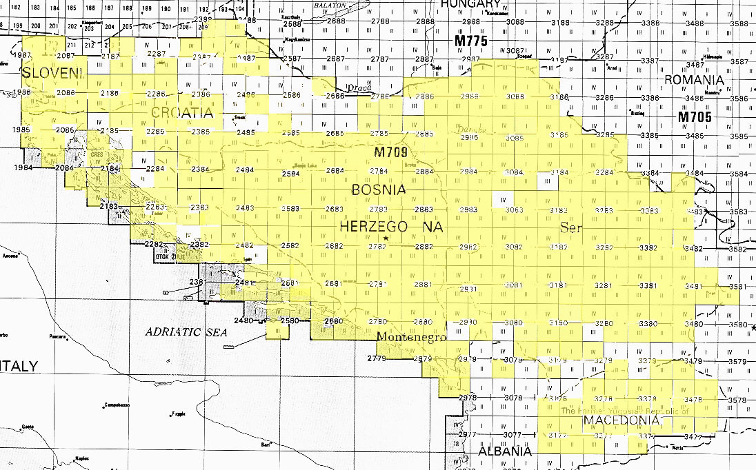
Američka  institucija U.S. Geological Survey je objavila karte cijelog
područja  bivše Jugoslavije pod public domain licencom, što znači da ih
možemo koristiti na Openstreetmap projektu. Izjava o licenci na slijedećem
linku:
http://www.lib.utexas.edu/maps/faq.html#3.html
Lista sa pdf-ovima ovdje:
https://www.lib.utexas.edu/maps/topo/former_yugoslavia/
Nažalost nisu skenirane sve karte, žuto su obojane regije sa podlogama:
http://www.lib.utexas.edu/maps/topo/former_yugoslavia/index_map.jpg
Vidi se da Hrvatska i Slovenija nemaju baš puno, ali treba i ovo
iskoristiti.

Naš član dodobas je geokodirao karte i stavili smo ih na server kojeg
održava korisnik hbogner na Geodetskom fakultetu u Zagrebu.
Zato vas pozivamo da koristite te podloge kako bi popunili Openstreetmap
projekt sa što više korisnih podataka!

Predlažem da se za elemente ucrtane preko tih podloga koristi tag *source=U.S.
Defense Mapping Agency *kako bi lako našli što je mapirano sa tim kartama.

Kako ih koristiti?

U JOSMu:
Kliknuti na Edit > Preferences... > WMS TMS > + (Plus dolje desno) > TMS

Menu name= *U.S. Defense* osm-hr
TMS URL= http://tms.osm-hr.org/1.0.0/all_ustopo/{zoom}/{x}/{y}.png

Screenshot: http://
<http://osm-hr.org/josm.png>osm-hr.org/josm<http://osm-hr.org/josm.png>
.png <http://osm-hr.org/josm.png>

U Potlatchu:
Kliknuti na Background > Edit...
I napraviti novi upis:

Name= *U.S. Defense* osm-hr
URL= http://tms.osm-hr.org/1.0.0/all_ustopo/$z/$x/$y.png

Screenshot: *http://osm-hr.org/potlach.jpg* <http://osm-hr.org/potlach.jpg>

Ako ima problema, javite nam se!

http://osm-hr.org/

P.S.
Pripazite na loše podatke koji će se zbog promjene licence brisati 1.
Aprila. Više o tome na wiki stranici o Remapiranju:
http://wiki.openstreetmap.org/wiki/Hr:Remapping

*English*

*New **imagery*

Hi from croatia mappers!

The U.S. Geological Survey has made public maps of the whole Ex Yugoslavia
under the Public Domain license, which means we can use them in the
Openstreetmap project. Statement about the license on the following link:
http://www.lib.utexas.edu/maps/faq.html#3.html
List of maps in pdf format here:
https://www.lib.utexas.edu/maps/topo/former_yugoslavia/
Unfortunately, not all maps are scanned, the yellow areas are available:
http://www.lib.utexas.edu/maps/topo/former_yugoslavia/index_map.jpg
It's obvious that Croatia and Slovenia don't have much, but it should be
used.

Our member dodobas geocoded the maps and we put them on the server
maintained by user hbogner on the Faculty of Geodesy in Zagreb.
We are inviting you to use the imagery to fill the Openstreetmap with as
much usefull data possible!

I suggest you use the tag *source=U.S. Defense Mapping Agency *for the
elements drawn over these backgrounds so we can easily find what is drawn
with these maps.

How to use them?

In JOSM:
Go to Edit > Preferences... > WMS TMS > + (Plus sign lower right) > TMS

Menu name= USGS osm-hr
TMS URL = http://tms.osm-hr.org/1.0.0/all_ustopo/{zoom}/{x}/{y}.png

Screenshot: http://
<http://osm-hr.org/josm.png>osm-hr.org/josm<http://osm-hr.org/josm.png>
.png <http://osm-hr.org/josm.png>

In Potlatch:
Go to Background > Edit...
Make a new line:

Name= USGS osm-hr
URL= http://tms.osm-hr.org/1.0.0/all_ustopo/$z/$x/$y.png

Screenshot: *http://osm-hr.org/potlach.jpg* <http://osm-hr.org/potlach.jpg>

If there are any problems, contact us!

http://osm-hr.org/

P.S. Watch out for bad data that is going to be erased because of the
license change on April 1. More about that on the page about Remapping:
http://wiki.openstreetmap.org/wiki/Remapping
_______________________________________________
Talk-si mailing list
Talk-si@openstreetmap.org
http://lists.openstreetmap.org/listinfo/talk-si