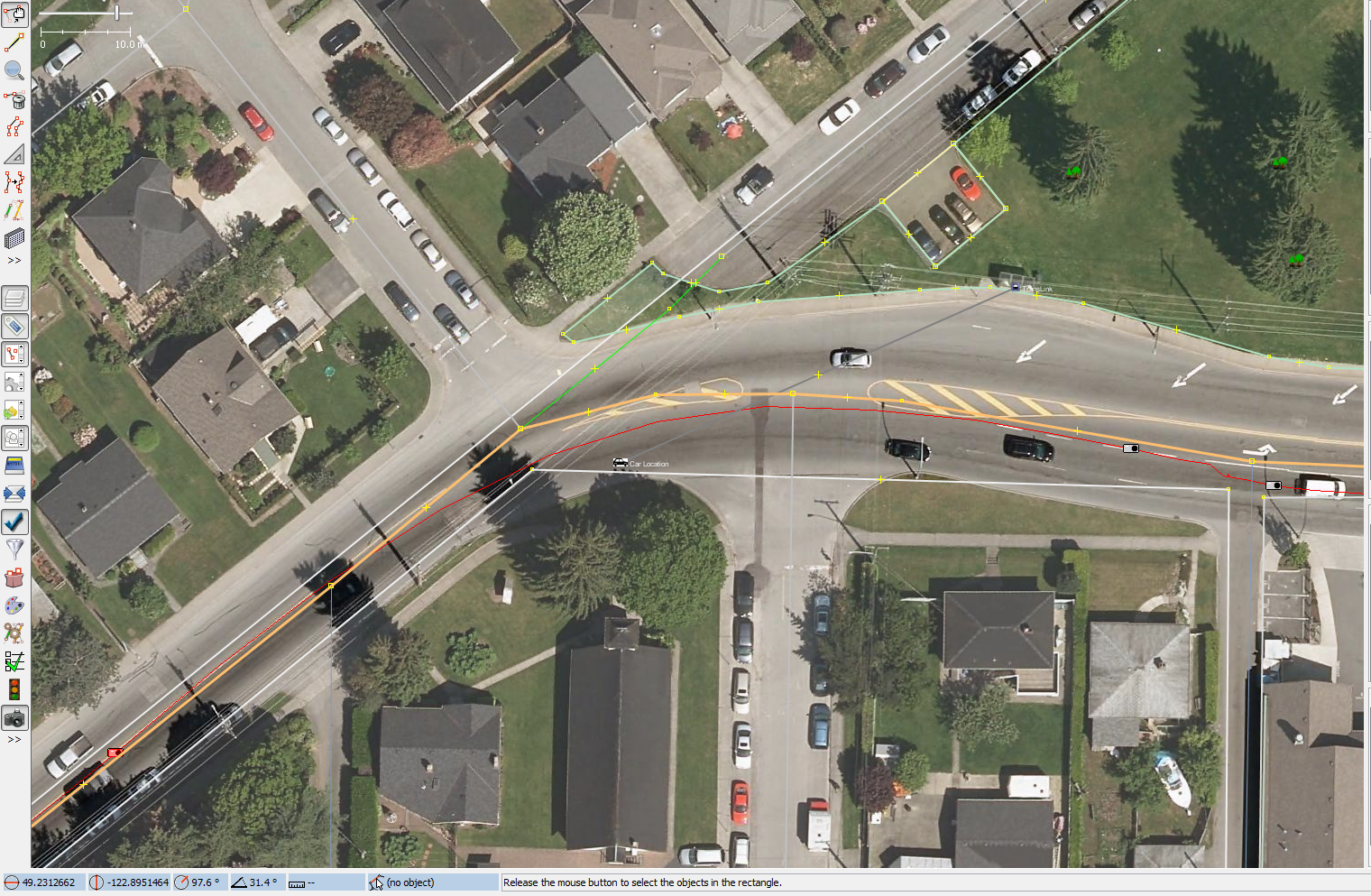
The road signs, max speeds and bus stops don't take long to tag. Take the
bus stop in IMG_3429.JPG as an example.
http://pnorman.dev.openstreetmap.org/photomapping/example_bus_stop.png is
what the area looks like in JOSM, with my car location indicated
When quickly going through the image I can easily identify that there is a
bus stop here. Seeing that there is a bus stop, I first have to identify
where it is. Neglecting GPS error, the bus stop is about 50m away from my
car and on the other side of the road. As this bus stop has a shelter I can
easily see it on my imagery. If it didn't, I would have to count power
poles, look at curves in the road or some other technique to get the precise
location. Even if I had no imagery I would want to get the stop on the
correct side of the road.

Suppose there is no bus_stop in OSM. I then need to add a node to where it
is with highway=bus_stop. I then look at the bus stop and see that it has a
shelter, bench, is wheelchair accessible, has a waste basket and is operated
by TransLink. I then convert these to shelter=yes bench=yes wheelchair=yes
amenity=waste_basket operator=TransLink. If the image was high enough
quality I would add ref=* but my camera can't make it out from 50m away.

To simply create a highway=bus_stop at my position would be wrong. I'm
driving on the right side of the road and the bus stop is on the left. Even
identifying the bus_stop doesn't help much, that's the easiest part of
adding it.

How would your proposed plugin help me?

> -----Original Message-----
> From: Nikhil Upadhye [mailto:[email protected]]
> Sent: Tuesday, April 10, 2012 6:52 AM
> To: [email protected]
> Subject: Re: [OSM-talk] An example photo/video mapping trip
>
> Thanks Paul for sharing files!
> I have submitted proposal for JSOM plugin development to extract
> information from such images and videos under GSoC this year.
> This plugin will use image processing to extract the key features such
> as road signs, max speed, bus stop etc as you have indicated in some
> images. These extracted features from images/videos will be
> automatically added to map with respective tags after synchronizing with
> gps tracks.
>
> I would request if anyone has such images/videos along with gpx file to
> share here as these will be helpful while developing the plugin.
>
> --
> Nikhil Upadhye
>
>
>
> On Tue, Apr 10, 2012 at 7:11 AM, Paul Norman <[email protected]> wrote:
> > A few GSoC students have made proposals relating to video and photo
> mapping.
> > As I make good use of photos from my car for mapping I thought I'd
> > prepare a set of annotate photos, pointing out objects that I map.
> >
> > I've finished these and placed them at
> > http://pnorman.dev.openstreetmap.org/photomapping/example_photomap_hig
> > hway.z
> > ip
> > The zip file includes the images, the GPX track and some notes. The
> > image files have coloured rectangles indicating different objects with
> > the key in the notes.
> >
> > The trip is a mix of residential, industrial and highway travel. Most
> > of the time spent entering the data from this trip would normally be
> > typing out the tagging for POIs and shops.
> >
> > My typical trip involves much less highway travel and much more travel
> > through retail and commercial landuse where I can spend a couple
> > minutes with one picture adding all the shops.
> >
> > The photos were taken 10 seconds apart from a camera mounted in about
> > the middle-right of my car and my GPX track comes from my garmin.
> >
> >
> > _______________________________________________
> > talk mailing list
> > [email protected]
> > http://lists.openstreetmap.org/listinfo/talk
>
> _______________________________________________
> talk mailing list
> [email protected]
> http://lists.openstreetmap.org/listinfo/talk


_______________________________________________
talk mailing list
[email protected]
http://lists.openstreetmap.org/listinfo/talk