from David Locklear

( for Texas history buffs only )   [ others should definitely hit
delete button ]
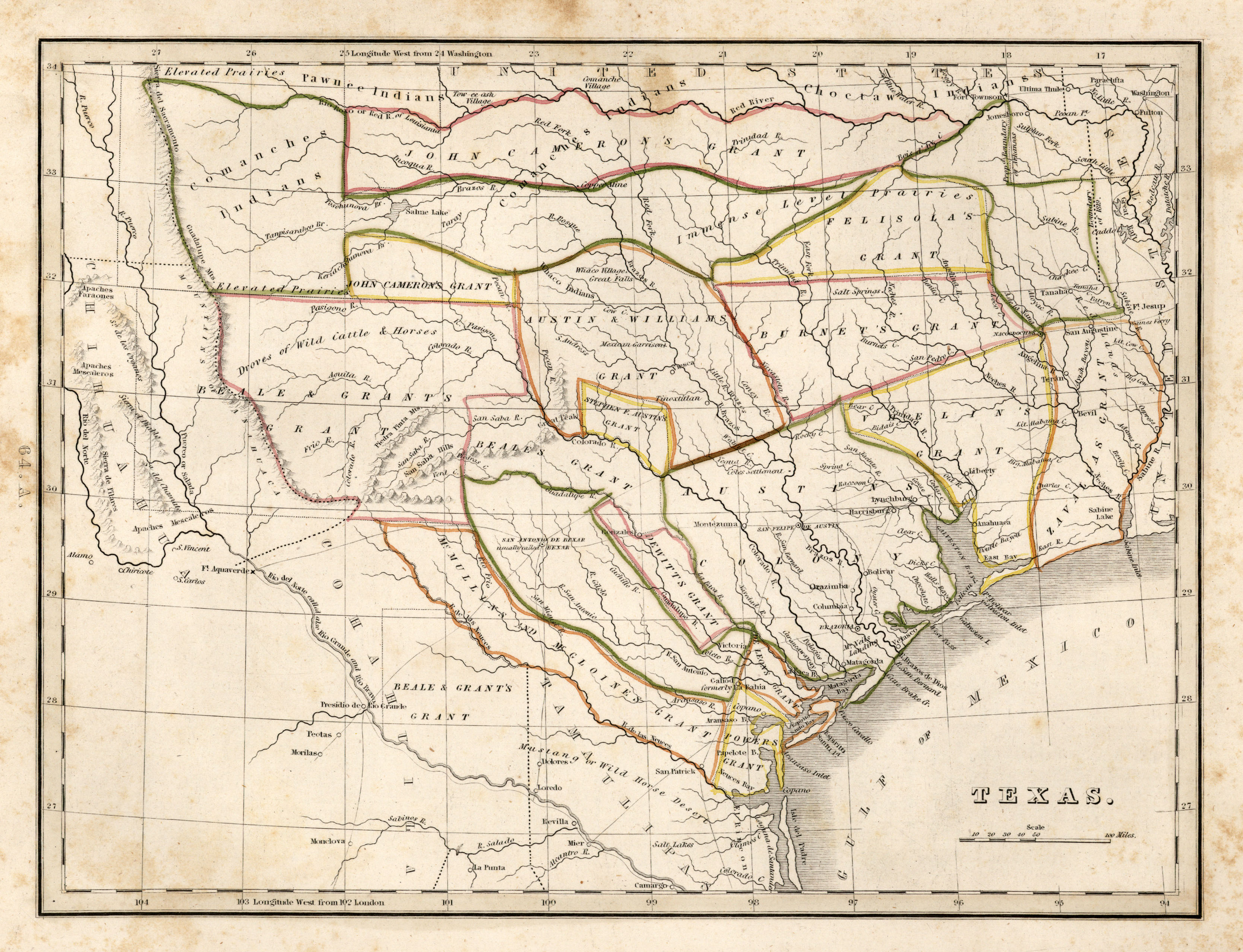
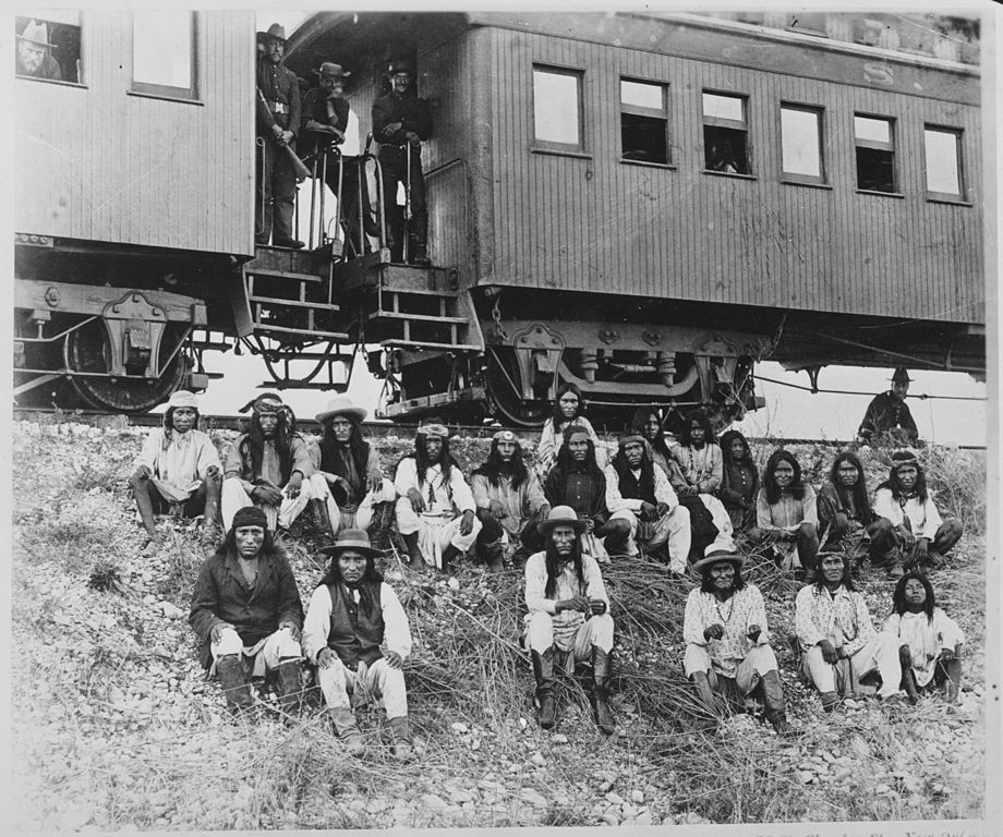
This is a very long-winded follow-up to my previous post.

I am only posting this because my earlier post came the day before it
was announced on the news that some library archivist found an old map
of Texas from 1844.    So I decided to amend my history lesson to
include a map image, and elaborate my
thoughts in great detail.

Before we get started,

I would like to discuss the term "speleo-geography", which I am
re-defining here as the study of politcal and cultural aspects near a
karst region.
( not to be confused with Dunkley's definition, which I am not
familiar with, nor its use
in the mid-1960's in a few NSS science articles, also which I am not
familiar with )
[ I have seen the word, speleography, used in a similar context, by
Wayne White, but to me that is the study of the activities inside the
cave or near the entrance, such as mining history ]

So this is Part 2 of my previous post which should have been titled:


"The Unique Speleo-Geography of Edwards, Uvalde, and Kinney Counties."
by David Locklear


The map link below shows a map more related to the point I was trying to
make.

http://www.lib.utexas.edu/maps/historical/bradford-texas-1835-01.jpg

A cartographer drew this map in 1835, the same year as the Battle of Gonzales
( see link at the bottom ).


This page will let you zoom in some on the map by just right-clicking on your
mouse.

If you look at the area where Devil's Sinkhole is, you will see it is
shown in the
northern part of the Mexican State of Coahuila, as I earlier described.


There were numerous maps from that era, and some dispute one another, especially
in west Texas.      Since the southern boundary then was the Nueces
River, and it suddenly fizzles out and splits up in or near Edwards
County, the cartographers had a problem.

The border between Chihuahua and Coahila in the area of Devil's
Sinkhole is difficult to decipher, but I am pretty sure the cave was
in northern Coahuila.    It might be interesting to find the spot
where Chihuahua, Texas and Coahuila came together, and put a marker
there.   One would need to research some good maps of the that area
from the 1830's to verify.   My guess is that it would be in the town
of Rocksprings, but not any further east of there, and certainly no
further west than the Devil's River, as the maps show the northern
boundary of Chihuahua there to be a group of hills and not a river.  (
I have another theory that the northern boundary of Edwards County is
related to this historical spot, but that is for somebody else to
research )

The historical point I am trying to make with all of this hoopla, is
that the complicated history of the region where the cave lies, is
also related to the history of Coahuila.     Since that state did not
get its statehood, until 1824. it could be stated that Devil's
Sinkhole was, for about 275 years, in an area known as "La Nueva
Extremadura," and the city of Monclova was the controlling government
body of the cave area.  But the indians still thought they owned it.
 Surely the Lipan Apache or Commanches controlling that area, called
the region something else.   ( see photo link at bottom of some of the
last known indians from the area )   The language and culture appears
to
be extinct.   Only about 200 people claim any affiliation to them (
see link at the bottom )


It is also worth noting that from the perspective of the people of
Coahuila, that Devil's
Sinkhole was briefly ( in 1840 ) in a nation called, "The Republic of
the Rio Grande."
( That is why I was saying Devil's Sinkhole was never really in The
Republic of Texas. )


http://en.wikipedia.org/wiki/Republic_of_the_Rio_Grande

So the new map ( in yesterday's news ), shows that as early as 1844,
the U.S. Gov't considered the region where Devil's Sinkhole lies to be
in Texas.   I do not think that
is news to anybody, but it further confirms the early history of the
war to occupy and
steal that territory from Mexico.   It is a known fact that U.S.
troops occupied the
disputed border area ( in Brownsville ) before the war officially started.


On a related note,

Most people think that after 1848, everything was normal along the Rio
Grande, and
both sides lived happily ever after.     But the river changed course.
( see link at the bottom )


Feel free to correct me on any of this.

Also,

A geography student, and someone more poetic than me, and more of a
history buff, might be able to expand on this and put something on
paper worth reading.
( I actually did complete a geography course at A&M, and had a similar term
paper )

David Locklear


Ref:

http://en.wikipedia.org/wiki/Siete_Leyes#mediaviewer/File:Political_divisions_of_Mexico_1836_(location_map_scheme).svg

http://en.wikipedia.org/wiki/Battle_of_Gonzales

http://en.wikipedia.org/wiki/Chamizal_dispute

http://www.philaprintshop.com/images/carhartmex.jpg

http://casitasdegila.com/blog/wp-content/uploads/2013/03/march12.jpg

http://www.lipanapache.org/StateRecognition/StateRecognitionEvent.html

http://en.wikipedia.org/wiki/Thornton_Affair
_______________________________________________
Texascavers mailing list | http://texascavers.com
Texascavers@texascavers.com | Archives:
http://www.mail-archive.com/texascavers@texascavers.com/
http://lists.texascavers.com/listinfo/texascavers