*
*
[image: File:Diomede Islands Bering Sea Jul
2006.jpg]<http://upload.wikimedia.org/wikipedia/commons/c/c6/Diomede_Islands_Bering_Sea_Jul_2006.jpg>


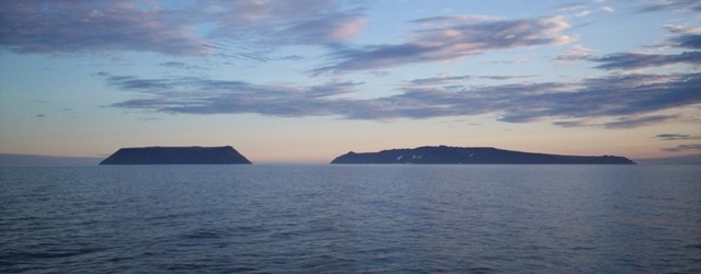
Above photo shows two islands in sea facing each other silently.
These are not ordinary islands.They are located in Bering Straits.
They belong to two Super Powers - Russia and USA and represent two different
days of calender at any given time.
They are just 2.4 km apart from each other.

The bigger one called Big Diomede with an area of 29 km2 with no population,

belongs to Russia and part of Siberia - 25 km from main land.
International Date Line is about 1.8 km east of this island

The smaller one is called Little Diomede with an area 7.3 km2 with a
population of 170, belongs to Alaska - 25 km from main land
International Date Line is about 0.6 km west of this island.

On a clear day, by looking at Big Diomede from Little Diomede -
one can see tomorrow as the time diffrenece betwen the two islands is
exactly 24 hrs.

When Imperial sold far flung area Alaska ( more than 1.5 million km2 ) for $
7.2 Million ( $ 113 million in today's value ) in March 1867,
the border line between Alaska and Siberia was drawn between these two
islands.

USSR under communism during Cold War era always repented the 1867 selling of
Alaska to USA.


Close up Sattelite View of both islands

[image: File:Bering
Strait.jpeg]<http://upload.wikimedia.org/wikipedia/commons/1/16/Bering_Strait.jpeg>

Sattelite view of Bering Straits - Siberia is towards left  & Alaska is in
on right side.


Many Russians and even Americans may not be aware of these facts as these
islands are quite far away from them.