Have been playing with setting up a co-ordinated set of plan and elevation
atlas' and have come up with some issues;
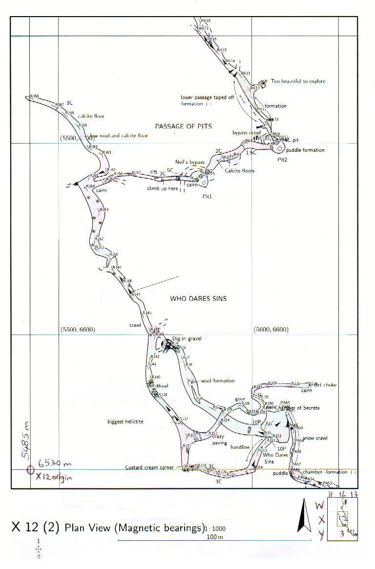
1.      Where elevations are perpendicular to the co-ord system grid (viewed
N, S, W, or E) then vertical grid lines (or positions if you use the default
cross hairs) would be appropriate, but there is no option for this at
present.  (This applies to map outputs as well)


2.      Using the 'origin' and 'origin-label' works well in standalone plan
view but seem to work poorly when trying to use a consistent 3 dimensional
tessellation for a set of plans and elevations orthogonal  to the
co-ordinate system. (Of course it would not work very easily in concept it
were not orthogonal - and keeping a single three dimensional atlas origin
point)
As per the attached, I have set the atlas origin so that the atlas plan with
origin at bottom left is called X 12 in the navigation box, and so that the
atlas elevation with origin at bottom left should be 5 X.  The atlas page is
setup so that the drawing length along each of the pages is the same (ie
PLAN size + 2xoverlap = ELEV size + 2x overlap).
What I find is that the elevation labelling is incorrect (ie the origin
sheet for the elevation is labelled 5 V, (not 5 X) and that because my
elevation is looking west, the labels increase in the wrong direction.

I think there is a bug in the labelling of the atlas pages in elevation.
There needs to be a means of reversing the direction that the ABC, 123
increase in, so that plans and elevations can use a consistent atlas page
labelling scheme.


These effects are the same for version 5.2 and 0.5.1


Layout values used to get the attached outputs.

#Atlas plan origin definition

  origin 5485 6530 1075 metres   #co-ords of lower left corner of 'origin'
atlas page

  origin-label 12 X #label & type <across> <down>


#Atlas elevation origin definition

  origin 5485 6530 1075 metres   #co-ords of lower left corner of 'origin'
atlas page

  origin-label X 5 #label & type <across> <down>


3.      As I have mentioned before, labelling of the page and atlas labels
on the navigation box (as I have hand written on the attached) would help
immensely.


4.      Implementing the map-image feature (or something similar) in atlas'
would be useful.  Would need to specify the page(s) the image should appear
on I guess.  While I'm at it, it would be nice to apply a scale factor to
map images, to reduce the to & fro between image editor (for resizing) and
therion.


Stacho and Martin, as always your efforts are greatly appreciated.

Bruce

-------------- next part --------------
An HTML attachment was scrubbed...
URL:
<http://mailman.speleo.sk/pipermail/therion/attachments/20080816/01e09c89/attachment.html>
-------------- next part --------------
A non-text attachment was scrubbed...
Name: Atlas Plan.jpg
Type: image/jpeg
Size: 104686 bytes
Desc: not available
URL:
<http://mailman.speleo.sk/pipermail/therion/attachments/20080816/01e09c89/attachment.jpg>
-------------- next part --------------
A non-text attachment was scrubbed...
Name: Atlas Elev270.jpg
Type: image/jpeg
Size: 84957 bytes
Desc: not available
URL:
<http://mailman.speleo.sk/pipermail/therion/attachments/20080816/01e09c89/attachment-0001.jpg>