The GeoTools team is pleased to announce the release of GeoTools 20.0
<https://sourceforge.net/projects/geotools/files/GeoTools%2020%20Releases/20.0/>
:
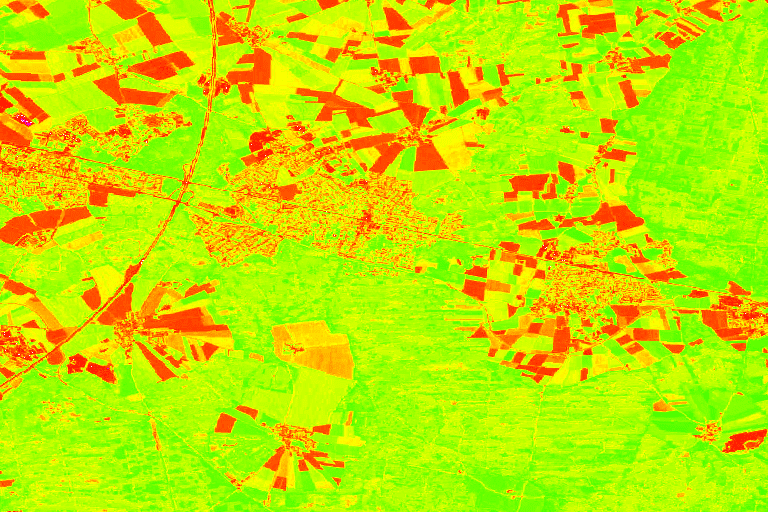
   - geotools-20.0-bin.zip

<https://sourceforge.net/projects/geotools/files/GeoTools%2020%20Releases/20.0/geotools-20.0-bin.zip/download>
   - geotools-20.0-doc.zip

<https://sourceforge.net/projects/geotools/files/GeoTools%2020%20Releases/20.0/geotools-20.0-doc.zip/download>
   - geotools-20.0-userguide.zip

<https://sourceforge.net/projects/geotools/files/GeoTools%2020%20Releases/20.0/geotools-20.0-userguide.zip/download>
   - geotools-20.0-project.zip

<https://sourceforge.net/projects/geotools/files/GeoTools%2020%20Releases/20.0/geotools-20.0-project.zip/download>

This is the first release of the 20.x series, now marked as stable and
deemed suitable for production systems, while 19.x switches to maintenance
mode and 18.x moves to unsupported.

This release is also available from our Maven
<http://download.osgeo.org/webdav/geotools/>*repository*, and is made in
conjunction with GeoServer 2.14.0.

This release includes a various major changes.
JTS upgraded to version 1.16
JTS has been upgraded to version 1.16. This marks a significant change in
package naming, the library has switched from "com.vividsolutions" to
"org.locationtech"  packages and all GeoTools code has been updated to
follow suit.

JTS classes are widely used in GeoTools, as a result the client code using
GeoTools will also have to be modified to follow suite. Thankfully the
changes amount to a search and replace and can be easily automated, please
check the upgrade instructions
<http://docs.geotools.org/latest/userguide/welcome/upgrade.html#geotools-20-x>
available
in the GeoTools site.
Units library migrated to JSR-363
GeoTools was using an aging and un-maintained units library and this
development round moved it to a modern and maintained set of packages
compatible with Java 10. Like the JTS upgrade this might require the client
code to be updated, both in terms of packages and in terms of classes and
methods being used.

We have provided a *Units* utility class, providing an easy way to match
unit defined at runtime with the the correct constant.

Unit deg = Units.autoCorrect(SI.RADIAN.multiply(0.0174532925199433));

Please check the upgrade instructions
<http://docs.geotools.org/latest/userguide/welcome/upgrade.html#geotools-20-x>
available
in the GeoTools site for more details.

Thanks to César Martínez Izquierdo and the participants of the OSGeo Code
sprint for this work.
Various other assorted dependencies upgrades
The release upgrades many dependencies to newer versions, in particular:

   - Batik upgraded to version 1.10
   - Commons-lang to version 3.7
   - Commons-io to version 2.6
   - Mysql JDBC driver to 5.1.46
   - HSQLDB to 2.4.1
   - SQLite-JDBC to version 2.23.1
   - GeographicLib upgrades to version 1.49

These upgrades should not cause major incompatibilities, but look for for
potential API changes.
Channel selection name allow expressions
GeoTools 20.x allows expressions to be used in SourceChannelName SLD
elements, and in their code counterpart, thus allowing dynamic channel
selection. This is welcomed news for anyone building applications that
display multispectral or hyperspectral data, thus avoiding the need to
build many different styles for the various interesting false color
combinations.

Here is an SLD example:

<RasterSymbolizer>
  <ChannelSelection>
    <RedChannel>
      <SourceChannelName>
          <ogc:Function name="env">
             <ogc:Literal>B1</ogc:Literal>
             <ogc:Literal>2</ogc:Literal>
          </ogc:Function>
      </SourceChannelName>
    </RedChannel>
    <GreenChannel>
      <SourceChannelName>
          <ogc:Function name="env">
             <ogc:Literal>B2</ogc:Literal>
             <ogc:Literal>5</ogc:Literal>
          </ogc:Function>
      </SourceChannelName>
    </GreenChannel>
    <BlueChannel>
      <SourceChannelName>
          <ogc:Function name="env">
             <ogc:Literal>B3</ogc:Literal>
             <ogc:Literal>7</ogc:Literal>
          </ogc:Function>
      </SourceChannelName>
    </BlueChannel>
  </ChannelSelection>
<RasterSymbolizer>

Map algebra
This release adds support for an efficient map algebra package knows as
Jiffle. Jiffle has been the work of a former GeoTools contributor, Michael
Bedwards, that has been salvaged, upgraded to support Java 8, and
integrated in jai-ext. From the there support has been added into the
GeoTools gt-process-raster module, to be used either directly or as a
rendering transformation.

The following SLD style calls onto Jiffle to perform a NDVI calculation on
top of Sentinel 2 data:

<?xml version="1.0" encoding="UTF-8"?><StyledLayerDescriptor
xmlns="http://www.opengis.net/sld";
xmlns:ogc="http://www.opengis.net/ogc";
xmlns:xlink="http://www.w3.org/1999/xlink";
xmlns:xsi="http://www.w3.org/2001/XMLSchema-instance";
xsi:schemaLocation="http://www.opengis.net/sldhttp://schemas.opengis.net/sld/1.0.0/StyledLayerDescriptor.xsd";
version="1.0.0">
  <NamedLayer>
    <Name>Sentinel2 NDVI</Name>
    <UserStyle>
      <Title>NDVI</Title>
      <FeatureTypeStyle>
        <Transformation>
          <ogc:Function name="ras:Jiffle">
            <ogc:Function name="parameter">
              <ogc:Literal>coverage</ogc:Literal>
            </ogc:Function>
            <ogc:Function name="parameter">
              <ogc:Literal>script</ogc:Literal>
              <ogc:Literal>
                nir = src[7];
                vir = src[3];
                dest = (nir - vir) / (nir + vir);
              </ogc:Literal>
            </ogc:Function>
          </ogc:Function>
        </Transformation>
        <Rule>
          <RasterSymbolizer>
            <Opacity>1.0</Opacity>
            <ColorMap>
              <ColorMapEntry color="#000000" quantity="-1"/>
              <ColorMapEntry color="#0000ff" quantity="-0.75"/>
              <ColorMapEntry color="#ff00ff" quantity="-0.25"/>
              <ColorMapEntry color="#ff0000" quantity="0"/>
              <ColorMapEntry color="#ffff00" quantity="0.5"/>
              <ColorMapEntry color="#00ff00" quantity="1"/>
            </ColorMap>
          </RasterSymbolizer>
        </Rule>
      </FeatureTypeStyle>
    </UserStyle>
  </NamedLayer></StyledLayerDescriptor>

The performance is good enough for interactive display, and the result
looks as follows:

<https://3.bp.blogspot.com/-cw1pkZPwCPk/W3rU88oRypI/AAAAAAAAC08/RGbzV0_k7z4aecKSPRGcLZ_PT2yAItGSwCLcBGAs/s1600/s2-ndvi.png>
PostGIS store improvementsThe PostGIS datastore has been for years the only
one that could encode a few filter functions used in filters down into
native SQL, but it required a datastore creation flag to be enabled.
Starting with this release it will do so by default.

The functions supported for SQL encoding by the store are:

   - String functions: *strConcat, strEndsWith, strStartsWith,
   strEqualsIgnoreCase, strIndexOf, strLength, strToLowerCase, strToUpperCase,
   strReplace, strSubstring, strSubstringStart, strTrim, strTrim2*
   - Math functions: *abs, abs_2, abs_3, abs_4, ceil, floor*
   - Date functions: *dateDifference*

Along with improvements in the handling of GroupByVisitor, this makes for
efficient histogram computation directly in the database, while retaining
the ability to share the same code with other stores that do not have the
same optimizations.

This release adds support for "array" data type in the store, with full
reading and writing support, as well as native filtering (with index
support, where feasible).

Finally, it's now possible to read geometries with measures from PostGIS,
also thanks to JTS improved CoordinateSequence API, and encode the results
in GML (the encoding is subject to a configuration flag, as GML does not
officially support M encoding). The work will continue in the next few
month in order to cover more formats.
Image mosaic improvements
The image mosaic module never sleeps, in this release we see the following
improvements:

   - Support for remote images (e.g. S3 or Minio). In order to leverage
   this the mosaic index will have to be created up-front (manually, or with
   some home grown tools)
   - A new "virtual native resolution" read parameter allows the mosaic to
   compose outputs respecting a native resolution other than its native one
   (useful in case you want to give selective resolution access to different
   users)
   - Supporting multiple WKBs footprint for pixel precise overviews masking
   - A new read mask parameter allows to cut the image to a given geometry
   (again, helps in providing different selective views to different users)
   - Speed up NetCDF mosaics by allowing usage of stores coming from a
   repository

<https://github.com/geotools/geotools/blob/master/modules/library/api/src/main/java/org/geotools/data/Repository.java>,
   instead of re-creating them every time a NetCDF file is needed (to be setup
   in the auxiliary store config file, while the repository instance needs to
   be passed as a creation hint).
   - The mosaic now works against images without a proper CRS, setting them
   into the "CRS not found" wildcard CRS, aka "EPSG:404000"

App-schema improvements
The app-schema module got significant performance and functionality
improvements since 19.x series, in particular:

   - Better delegation of spatial filters on nested properties to native
   database
   - Improved support for multiple nested attribute matches in filters
   - It is now possible to use Apache SOLR as a data source for app-schema
   - The configuration files can be hosted on a remote HTTP server

Modules moving up and down
This release sees a number of modules moving down to unsupported due to
lack of maitainers, unsupported module being removed, while other modules
graduate to supported status. In particular:

   - The unsupported image-collection, sfs, efeature, caching,
   feature-aggregate and geotiff-new module have been removed from the code
   base (you can still find them in older releases and version control history)
   - The OGR and GTOPO30 modules have been downgraded to unsupported status
   due to lack of maintainership
   - The MongoDB module moves up to supported status

Building on Windows
The GeoTools project builds again on Windows (with tests) and all new pull
requests are verified using AppVeyor.

GeoTools is looking for Windows developers to join and help keep the build
passing, as well as locating and squashing a few intermittent failures
we're still experiencing.
Assorted improvements
Other highlights from our issue tracker release-notes
<https://osgeo-org.atlassian.net/secure/ReleaseNote.jspa?projectId=10001&version=16719>
:

   - Some speedups in in memory Expression evaluation, in particular
   attribute value extraction in simple features and equality tests
   - Support for "none" values in GeoCSS (to allow turning off
   symbolization/properties in override rules)

There is also a large set of bug fixes. For more information see the
release notes: (20.0
<https://osgeo-org.atlassian.net/secure/ReleaseNote.jspa?projectId=10001&version=16729>
 | 20-RC
<https://osgeo-org.atlassian.net/secure/ReleaseNote.jspa?projectId=10001&version=16719>
).
_______________________________________________
GeoTools-Devel mailing list
[email protected]
https://lists.sourceforge.net/lists/listinfo/geotools-devel