Thank you Torben for the release, and to everyone here who contributed!
--
Jody Garnett
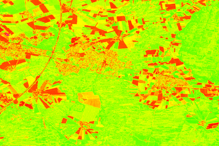
On Mon, 24 Sep 2018 at 09:26, Torben Barsballe <[email protected]>
wrote:

> The GeoTools team is pleased to announce the release of GeoTools 20.0
> <https://sourceforge.net/projects/geotools/files/GeoTools%2020%20Releases/20.0/>
> :
>
>    - geotools-20.0-bin.zip
>
> <https://sourceforge.net/projects/geotools/files/GeoTools%2020%20Releases/20.0/geotools-20.0-bin.zip/download>
>    - geotools-20.0-doc.zip
>
> <https://sourceforge.net/projects/geotools/files/GeoTools%2020%20Releases/20.0/geotools-20.0-doc.zip/download>
>    - geotools-20.0-userguide.zip
>
> <https://sourceforge.net/projects/geotools/files/GeoTools%2020%20Releases/20.0/geotools-20.0-userguide.zip/download>
>    - geotools-20.0-project.zip
>
> <https://sourceforge.net/projects/geotools/files/GeoTools%2020%20Releases/20.0/geotools-20.0-project.zip/download>
>
> This is the first release of the 20.x series, now marked as stable and
> deemed suitable for production systems, while 19.x switches to maintenance
> mode and 18.x moves to unsupported.
>
> This release is also available from our Maven
> <http://download.osgeo.org/webdav/geotools/>*repository*, and is made in
> conjunction with GeoServer 2.14.0.
>
> This release includes a various major changes.
> JTS upgraded to version 1.16
> JTS has been upgraded to version 1.16. This marks a significant change in
> package naming, the library has switched from "com.vividsolutions" to
> "org.locationtech"  packages and all GeoTools code has been updated to
> follow suit.
>
> JTS classes are widely used in GeoTools, as a result the client code using
> GeoTools will also have to be modified to follow suite. Thankfully the
> changes amount to a search and replace and can be easily automated, please
> check the upgrade instructions
> <http://docs.geotools.org/latest/userguide/welcome/upgrade.html#geotools-20-x>
>  available
> in the GeoTools site.
> Units library migrated to JSR-363
> GeoTools was using an aging and un-maintained units library and this
> development round moved it to a modern and maintained set of packages
> compatible with Java 10. Like the JTS upgrade this might require the client
> code to be updated, both in terms of packages and in terms of classes and
> methods being used.
>
> We have provided a *Units* utility class, providing an easy way to match
> unit defined at runtime with the the correct constant.
>
> Unit deg = Units.autoCorrect(SI.RADIAN.multiply(0.0174532925199433));
>
> Please check the upgrade instructions
> <http://docs.geotools.org/latest/userguide/welcome/upgrade.html#geotools-20-x>
>  available
> in the GeoTools site for more details.
>
> Thanks to César Martínez Izquierdo and the participants of the OSGeo Code
> sprint for this work.
> Various other assorted dependencies upgrades
> The release upgrades many dependencies to newer versions, in particular:
>
>    - Batik upgraded to version 1.10
>    - Commons-lang to version 3.7
>    - Commons-io to version 2.6
>    - Mysql JDBC driver to 5.1.46
>    - HSQLDB to 2.4.1
>    - SQLite-JDBC to version 2.23.1
>    - GeographicLib upgrades to version 1.49
>
> These upgrades should not cause major incompatibilities, but look for for
> potential API changes.
> Channel selection name allow expressions
> GeoTools 20.x allows expressions to be used in SourceChannelName SLD
> elements, and in their code counterpart, thus allowing dynamic channel
> selection. This is welcomed news for anyone building applications that
> display multispectral or hyperspectral data, thus avoiding the need to
> build many different styles for the various interesting false color
> combinations.
>
> Here is an SLD example:
>
> <RasterSymbolizer>
>   <ChannelSelection>
>     <RedChannel>
>       <SourceChannelName>
>           <ogc:Function name="env">
>              <ogc:Literal>B1</ogc:Literal>
>              <ogc:Literal>2</ogc:Literal>
>           </ogc:Function>
>       </SourceChannelName>
>     </RedChannel>
>     <GreenChannel>
>       <SourceChannelName>
>           <ogc:Function name="env">
>              <ogc:Literal>B2</ogc:Literal>
>              <ogc:Literal>5</ogc:Literal>
>           </ogc:Function>
>       </SourceChannelName>
>     </GreenChannel>
>     <BlueChannel>
>       <SourceChannelName>
>           <ogc:Function name="env">
>              <ogc:Literal>B3</ogc:Literal>
>              <ogc:Literal>7</ogc:Literal>
>           </ogc:Function>
>       </SourceChannelName>
>     </BlueChannel>
>   </ChannelSelection>
> <RasterSymbolizer>
>
> Map algebra
> This release adds support for an efficient map algebra package knows as
> Jiffle. Jiffle has been the work of a former GeoTools contributor, Michael
> Bedwards, that has been salvaged, upgraded to support Java 8, and
> integrated in jai-ext. From the there support has been added into the
> GeoTools gt-process-raster module, to be used either directly or as a
> rendering transformation.
>
> The following SLD style calls onto Jiffle to perform a NDVI calculation on
> top of Sentinel 2 data:
>
> <?xml version="1.0" encoding="UTF-8"?><StyledLayerDescriptor
> xmlns="http://www.opengis.net/sld"; xmlns:ogc="http://www.opengis.net/ogc";
> xmlns:xlink="http://www.w3.org/1999/xlink";
> xmlns:xsi="http://www.w3.org/2001/XMLSchema-instance";
> xsi:schemaLocation="http://www.opengis.net/sldhttp://schemas.opengis.net/sld/1.0.0/StyledLayerDescriptor.xsd";
>  version="1.0.0">
>   <NamedLayer>
>     <Name>Sentinel2 NDVI</Name>
>     <UserStyle>
>       <Title>NDVI</Title>
>       <FeatureTypeStyle>
>         <Transformation>
>           <ogc:Function name="ras:Jiffle">
>             <ogc:Function name="parameter">
>               <ogc:Literal>coverage</ogc:Literal>
>             </ogc:Function>
>             <ogc:Function name="parameter">
>               <ogc:Literal>script</ogc:Literal>
>               <ogc:Literal>
>                 nir = src[7];
>                 vir = src[3];
>                 dest = (nir - vir) / (nir + vir);
>               </ogc:Literal>
>             </ogc:Function>
>           </ogc:Function>
>         </Transformation>
>         <Rule>
>           <RasterSymbolizer>
>             <Opacity>1.0</Opacity>
>             <ColorMap>
>               <ColorMapEntry color="#000000" quantity="-1"/>
>               <ColorMapEntry color="#0000ff" quantity="-0.75"/>
>               <ColorMapEntry color="#ff00ff" quantity="-0.25"/>
>               <ColorMapEntry color="#ff0000" quantity="0"/>
>               <ColorMapEntry color="#ffff00" quantity="0.5"/>
>               <ColorMapEntry color="#00ff00" quantity="1"/>
>             </ColorMap>
>           </RasterSymbolizer>
>         </Rule>
>       </FeatureTypeStyle>
>     </UserStyle>
>   </NamedLayer></StyledLayerDescriptor>
>
> The performance is good enough for interactive display, and the result
> looks as follows:
>
>
> <https://3.bp.blogspot.com/-cw1pkZPwCPk/W3rU88oRypI/AAAAAAAAC08/RGbzV0_k7z4aecKSPRGcLZ_PT2yAItGSwCLcBGAs/s1600/s2-ndvi.png>
> PostGIS store improvementsThe PostGIS datastore has been for years the
> only one that could encode a few filter functions used in filters down into
> native SQL, but it required a datastore creation flag to be enabled.
> Starting with this release it will do so by default.
>
> The functions supported for SQL encoding by the store are:
>
>    - String functions: *strConcat, strEndsWith, strStartsWith,
>    strEqualsIgnoreCase, strIndexOf, strLength, strToLowerCase, strToUpperCase,
>    strReplace, strSubstring, strSubstringStart, strTrim, strTrim2*
>    - Math functions: *abs, abs_2, abs_3, abs_4, ceil, floor*
>    - Date functions: *dateDifference*
>
> Along with improvements in the handling of GroupByVisitor, this makes for
> efficient histogram computation directly in the database, while retaining
> the ability to share the same code with other stores that do not have the
> same optimizations.
>
> This release adds support for "array" data type in the store, with full
> reading and writing support, as well as native filtering (with index
> support, where feasible).
>
> Finally, it's now possible to read geometries with measures from PostGIS,
> also thanks to JTS improved CoordinateSequence API, and encode the results
> in GML (the encoding is subject to a configuration flag, as GML does not
> officially support M encoding). The work will continue in the next few
> month in order to cover more formats.
> Image mosaic improvements
> The image mosaic module never sleeps, in this release we see the following
> improvements:
>
>    - Support for remote images (e.g. S3 or Minio). In order to leverage
>    this the mosaic index will have to be created up-front (manually, or with
>    some home grown tools)
>    - A new "virtual native resolution" read parameter allows the mosaic
>    to compose outputs respecting a native resolution other than its native one
>    (useful in case you want to give selective resolution access to different
>    users)
>    - Supporting multiple WKBs footprint for pixel precise overviews
>    masking
>    - A new read mask parameter allows to cut the image to a given
>    geometry (again, helps in providing different selective views to different
>    users)
>    - Speed up NetCDF mosaics by allowing usage of stores coming from a
>    repository
>
> <https://github.com/geotools/geotools/blob/master/modules/library/api/src/main/java/org/geotools/data/Repository.java>,
>    instead of re-creating them every time a NetCDF file is needed (to be setup
>    in the auxiliary store config file, while the repository instance needs to
>    be passed as a creation hint).
>    - The mosaic now works against images without a proper CRS, setting
>    them into the "CRS not found" wildcard CRS, aka "EPSG:404000"
>
> App-schema improvements
> The app-schema module got significant performance and functionality
> improvements since 19.x series, in particular:
>
>    - Better delegation of spatial filters on nested properties to native
>    database
>    - Improved support for multiple nested attribute matches in filters
>    - It is now possible to use Apache SOLR as a data source for app-schema
>    - The configuration files can be hosted on a remote HTTP server
>
> Modules moving up and down
> This release sees a number of modules moving down to unsupported due to
> lack of maitainers, unsupported module being removed, while other modules
> graduate to supported status. In particular:
>
>    - The unsupported image-collection, sfs, efeature, caching,
>    feature-aggregate and geotiff-new module have been removed from the code
>    base (you can still find them in older releases and version control
> history)
>    - The OGR and GTOPO30 modules have been downgraded to unsupported
>    status due to lack of maintainership
>    - The MongoDB module moves up to supported status
>
> Building on Windows
> The GeoTools project builds again on Windows (with tests) and all new pull
> requests are verified using AppVeyor.
>
> GeoTools is looking for Windows developers to join and help keep the build
> passing, as well as locating and squashing a few intermittent failures
> we're still experiencing.
> Assorted improvements
> Other highlights from our issue tracker release-notes
> <https://osgeo-org.atlassian.net/secure/ReleaseNote.jspa?projectId=10001&version=16719>
> :
>
>    - Some speedups in in memory Expression evaluation, in particular
>    attribute value extraction in simple features and equality tests
>    - Support for "none" values in GeoCSS (to allow turning off
>    symbolization/properties in override rules)
>
> There is also a large set of bug fixes. For more information see the
> release notes: (20.0
> <https://osgeo-org.atlassian.net/secure/ReleaseNote.jspa?projectId=10001&version=16729>
>  | 20-RC
> <https://osgeo-org.atlassian.net/secure/ReleaseNote.jspa?projectId=10001&version=16719>
> ).
> _______________________________________________
> GeoTools-Devel mailing list
> [email protected]
> https://lists.sourceforge.net/lists/listinfo/geotools-devel
>
_______________________________________________
GeoTools-Devel mailing list
[email protected]
https://lists.sourceforge.net/lists/listinfo/geotools-devel