Hi Daniel
When you ran v.clean, did you v.clean tool=break,rmdupl ?

I suspect you still may encounter a problem with road T junctions if the
vectors don't cross or intersect.  Take this simple example of 2 roads - NS,
and EW.  Each line has only 2 nodes - at the line’s  start and end points.
|—
The problem is when the horizontal line “undershoots” the vertical line.  The
break command will have no effect, and snapping won’t make any difference
because there is no midpoint node to which the horizontal line can attach
itself to.
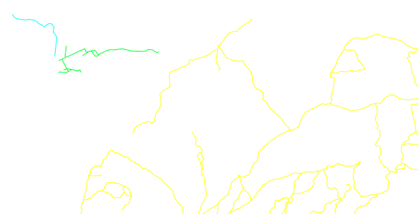
I’d be interested to hear how others have dealt with what is essentially a
“data preparation” issue in GRASS?

[The solution I ended up implementing used a PostGIS SQL custom function to
“break” overshoots and undershoots, with rules for correct treatment of bridges
and tunnels. The function is fast, and can be run in parallel when working with
continental-sized road networks.
After PostGIS, I import the “broken-up” network into GRASS and use v.clean to
snap the nodes, but NOT break the lines - as my PostGIS function has already
dealt with this.
The GRASS procedure involves running the v.clean in 5 steps, to avoid
inadvertently snapping a tunnel node to say a bridge node, just because they
are spatially close.
1) v.clean tool=snap # no bridges, no tunnels
2) v.clean tool=snap # bridges only
3) v.clean tool=snap # tunnels only
4) v.patch (steps 1-3)
5) v.clean tool=snap # on the patched layer, with a much smaller tolerance to
that used in steps 1-3 to again avoid say tunnel nodes inadvertently snapping
to bridge nodes.
We’re then good to go with v.net analysis.]

This may sound like a complicated process, but when using imperfect data to
model complex road networks in dense urban areas, its important to get the
vector topology as close as possible to the real world.  I’ve found this
process generates a highly representative, routable vector topology from
imperfect OSM data.

Your situation might be much simpler, which is not to say you won’t encounter
anomalies like you’ve already identified.

Mark


----------------------------------------------------------------------

Message: 1
Date: Thu, 15 Jan 2015 15:22:27 -0200
From: Daniel Victoria <[email protected]>
To: grass <[email protected]>
Subject: [GRASS-user] Checking and fixing roads for network analysis
Message-ID:
        <ca+irsjjekzq9eqq7igzcgl92k7umfdkujv6a-kvbtp7wn-x...@mail.gmail.com>
Content-Type: text/plain; charset="utf-8"

Hi List,

I'll need to perform some network analysis and right now I'm trying to see
if my roads map is all good. I know that there are some clearly isolated
areas on my roads network but I'd like to identify and fix the less obvious
ones.

Here is what I did:
1) Import road lines (v.in.ogr)
2) Clean the topology with snap tool, thresh=0.0001 (it's a latlong
location)
2) Create network (v.net using the nodes option --not sure if that was the
correct option)
3) Ran v.net.components to find the weakly connected components, not
setting any cost columns
4) Color roads lines according to the component number

By doing that I could spot the lines that were clearly disconnected
(net_components_unlink.png).
But I also found some lines that where disconnected even thou there are
nodes (red squares) linking them (apparently) -
net_components_pseudo_link.png

Should I increase my snapping threshold?
How can I see if my nodes are endnodes or located between two lines?

Thanks
Daniel
-------------- next part --------------
An HTML attachment was scrubbed...
URL:
<http://lists.osgeo.org/pipermail/grass-user/attachments/20150115/0dd532a1/attachment.html>
-------------- next part --------------
A non-text attachment was scrubbed...
Name: net_components_unlink.png
Type: image/png
Size: 25250 bytes
Desc: not available
URL:
<http://lists.osgeo.org/pipermail/grass-user/attachments/20150115/0dd532a1/attachment.png>
-------------- next part --------------
A non-text attachment was scrubbed...
Name: net_components_pseudo_link.png
Type: image/png
Size: 15279 bytes
Desc: not available
URL:
<http://lists.osgeo.org/pipermail/grass-user/attachments/20150115/0dd532a1/attachment-0001.png>

------------------------------

_______________________________________________
grass-user mailing list
[email protected]
http://lists.osgeo.org/mailman/listinfo/grass-user

End of grass-user Digest, Vol 105, Issue 25
*******************************************

_______________________________________________
grass-user mailing list
[email protected]
http://lists.osgeo.org/mailman/listinfo/grass-user