Hi all -

We'll have better prep next time, but thanks to Eric Butler & Stefano Costa
for joining in a fun conversation.
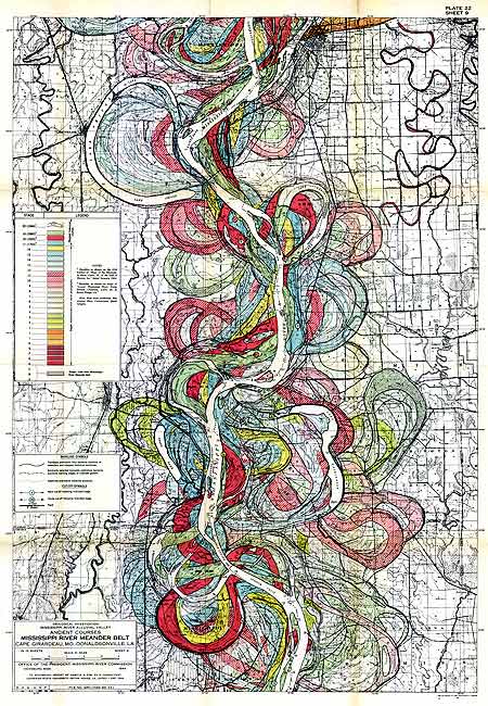
Items discussed:
- Introductions & review of interests
  -- Stefano is an old-time OSM'er who also works with archaeological
efforts in Italy, near the French border
  -- Eric is here in Seattle and cannot remember what was in that empty
retail space he passes on the street & wants to work backward as far as he
can, using the extant OSM database as a starting point

- Discussion of a potential workflow for extracting semantic information
from old maps using the OSM infrastructure
  -- In many ways, this is a modification of Brad Thompson's work with
pastmapper.com:  http://blog.pastmapper.com/vectorization/
  -- Used Seattle's Pioneer square in 1878 as an example
  -- Extract data for region of interest from modern OSM data using JOSM
  -- Delete everything down to the road grid
  -- If possible, warp a map to use as a base layer - see: www.mapwarper.net
  -- Trim the street grid down to what existed at the time
  -- Start... artisinally.... building things up from scratch, using
whatever sources are available
  -- See:  http://i.imgur.com/Mj2nh.jpg
      ---- Clearly, this is overtagged & many of these tags belong in other
systems, e.g. linked Historical Business Directories or People Directories
or image databases, but it's stored here for now
      ---- The roads are from modern OSM, the buildings & other information
are hand-added

- Discussion of need for getting the Rails Port up & running already
  -- I am behind on this, need to get moving
  -- Stefano pointed out need for just having something to get started with
  -- Stefano mentioned possible interest in Pleiades import, etc.

- Once the HO Rails Port is up & running, we could then identify what needs
to be fixed to simplify and streamline the workflow

- Stefano: Interest in mapping geographic changes over time
  -- e.g. paths of rivers over 100s of years

- Eric: Interest in being able to populate map information from geocoded
business information, which is good once there are addresses.

- Jeff: I'd like to see greater International participation in the
brainstorming for this effort, so that we're all more aware of various
related efforts around the world & to make sure we're putting enough global
perspective into our planning. (Is there ever too much?)

That's about it for now... need to get that Rails Port up and going...

Please send any suggestions or ideas to the list.

Next hangout: 9 January, 9am Seattle, 5pm London
- I'll market this one a little better & provide more advance notice.

Links discussed during the call (in chrono order (of course!))
www.pastmapper.com
http://www.burkemuseum.org/waterlines/
http://wiki.openstreetmap.org/wiki/OSM-Historic
http://www.showme.net/~fkeller/quake/images/missrivoldpaths.jpg
http://tiles.mapbox.com/jeffme/map/seattlebaist1912
http://orbis.stanford.edu/
http://omnesviae.org/
http://lodlam.net/

Thanks,
Jeff

--
Jeff Meyer
Global World History Atlas
twitter: GWHAThistory
www.gwhat.org
[email protected]
206-676-2347
_______________________________________________
Historic mailing list
[email protected]
http://lists.openstreetmap.org/listinfo/historic