Steve,
I agree the new features should be driven from specific use cases,
but I like to expand designs to handle unforeseen uses (hopefully
without adding complexity).
So I prefer
    GEOMTRANSFORM (getCentroid(labelpoly))
instead of
    GEOMTRANSFORM LABELBBOXCENTROID
My use cases for expanded GEOMTRANSFORM (from an earlier email with
Steve L):
-------------------
The solution of using a STYLE with GEOMTRANSFORM got me thinking of
using the technique to solve some of the labeling challenges:
2. Place polygon annotation on/inside boundary line
(http://trac.osgeo.org/mapserver/ticket/1592 point 8.)
- label the line geometry resulting from GEOMTRANSFORM
(buffer([shape], -3)) of the original polygon
5. Place line anno above (or below) when using ANGLE FOLLOW
- label the line geometry resulting from GEOMTRANSFORM
(buffer([shape], 5)) of the original line
- useful for labeling rivers above their geometry
Currently the LABEL object uses the original geometry. Do you think it
would be possible to [optionally?] use the GEOMTRANSFORMed geometry?
Similarly, would it be possible to have the LABEL's convex hull (or a
buffer the character boxes?) used as a clipping polygons of the layer's
geometry to address:
8. Erase layer's geometry (but not other layers) under label
   - possible syntax:  GEOMTRANSFORM ( clip( [labelpoly] ) )
  - useful for labeling contours

----------------

Best Regards,
Brent Fraser


On 12/11/2011 3:02 PM, Stephen Woodbridge wrote:
It seems to me that we should develop specific use cases that we are
trying to support.
We have one that this feature was developed for, and that is as Steve
L mention for labeling Highway Shields were the actual shield may be
composed of multiple parts that need to be be super imposed relative
to a label point, if I recall the details of that discussion without
looking it up again.
Ian, I think the point you are looking for is different. That would be
the centroid of the label polygon. That point may or may not be
coincidentally the same as the LABELPNT under some small set of
configuration parameters but by no means guaranteed to be the same.
I think that these points might be the same is you have a single line
of text, ie: not wrapped, and POSITION CC and probable ANGLE 0. But I
have not had time to test.
-Steve W

On 12/11/2011 4:18 PM, Ian Walberg wrote:
So is it expected that labelpnt generates a point with its center at
the middle of the bounding rectangle of the text?

Thanks

Ian


-----Original Message----- From:
mapserver-users-boun...@lists.osgeo.org
[mailto:mapserver-users-boun...@lists.osgeo.org] On Behalf Of Brent
Fraser Sent: Sunday, December 11, 2011 1:02 PM To: thomas bonfort Cc:
mapserver-users@lists.osgeo.org Subject: Re: [mapserver-users]
GEOMTRANSFORM LABELPNT example

Thomas,

I tracked it down to the LABELCACHE setting.

LABELCACHE ON  gives the expected results LABELCACHE OFF  gives my
old blue-dot-on-the-left results.

See attached PDFs.

Best Regards, Brent Fraser


On 12/11/2011 1:05 PM, thomas bonfort wrote:
There might have been a bug in the initial implementation. trying
it out with current trunk gives me the expected result, unless I'm
missing something.


On Sun, Dec 11, 2011 at 20:44, Brent
Fraser<bfra...@geoanalytic.com>   wrote:
Thomas, See comments below.

Best Regards, Brent Fraser


On 12/11/2011 12:26 PM, thomas bonfort wrote:
I think this is all expected behavior, although the
documentation may be incorrect.

LABELPNT draws a marker on the geographic position the label
is attached to. This corresponds to the center of the label
text only if the label is in position CC.
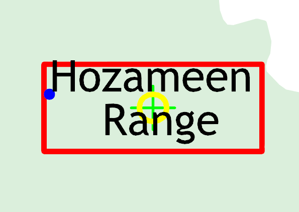
I think that is what is intended but my original test case (using
CC ) resulted in the LABELPNT rendered on the left side of the
labelpoly, see
http://lists.osgeo.org/pipermail/mapserver-dev/attachments/20110526/47c9bc8c/labelpnt-0001.png.
I had expected it to be coincident with the yellow circle and green
cross.
To draw a label at the center of the label text, another
geomtransform would have to be implemented, named e.g.
LABELBBOXCENTROID.
or maybe

GEOMTRANSFORM (centroid([LABELPOLY]))
regards, thomas

On Sun, Dec 11, 2011 at 19:34, Brent
Fraser<bfra...@geoanalytic.com> wrote:
Hey Jeff,

I've been looking into this too (not finished yet).  I'm
using v6.0.1 and can reproduce my original results (blue dot
to the left) AND Ian's (grey dot coincident with white dot).
Very strange.  My shapefile dataset gets reprojected from
geographic to UTM, so that may be causing the difference. I
need to look into that...

Best Regards, Brent Fraser


On 12/11/2011 10:57 AM, Jeff McKenna wrote:
On 11-12-11 11:20 AM, Ian Walberg wrote:
Here is the map file we are using ms4w 3.0.3.

We thought the larger grey circle should be drawn in the
center of the label text.

What have we done wrong?
I have done some testing on this on Windows, with MapServer
trunk (6.1-dev), here are my findings:

- I used Brent's original example styles (from
http://osgeo-org.1803224.n2.nabble.com/GEOMTRANSFORM-labelpnt-location-td6408065.html)
with Ian's FEATURE layer --> Brent's "Blue Dot" LABELPNT with
POSITION
CC is now correctly placed in the center of the label text
(so it seems this has been fixed in the code, but I can't
find the ticket that says that) - If I change to POSITION
LR (as in Ian's example layer) then I get Ian's issue
(LABELPNT is placed at the geometry location, not in the
center of the label text - but this is now an issue of
understanding the developer's logic (from that thread
SteveL says "Let me ponder this and get back to you. I
think it makes sense to use the label point geotransform
only with position CC so that it matches actual shape
location.")

That's all I know at this point (ha pun).

-jeff
_______________________________________________
mapserver-users mailing list mapserver-users@lists.osgeo.org
http://lists.osgeo.org/mailman/listinfo/mapserver-users
_______________________________________________ mapserver-users
mailing list mapserver-users@lists.osgeo.org
http://lists.osgeo.org/mailman/listinfo/mapserver-users
_______________________________________________
mapserver-users mailing list
mapserver-users@lists.osgeo.org
http://lists.osgeo.org/mailman/listinfo/mapserver-users
_______________________________________________
mapserver-users mailing list
mapserver-users@lists.osgeo.org
http://lists.osgeo.org/mailman/listinfo/mapserver-users