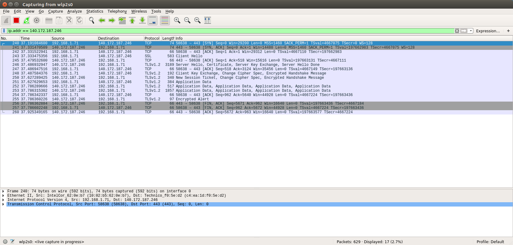
Thanks Jorge, that helps confirm my suspicion.  Are you running on linux?
Based on this ticket (https://hub.qgis.org/issues/11473
<https://hub.qgis.org/issues/11473>), it sounds like the supported protocols
may be dependent on the version of Qt that QGIS is using. Do you happen to know
which version you’re using?
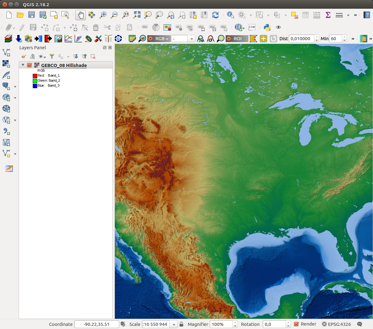
—john

> On Jan 5, 2017, at 4:30 PM, Jorge Gustavo Rocha <[email protected]> wrote:
>
> Hi John,
>
> I've captured QGIS packets to/from the WMS service, after clicking "Connect"
> on QGIS (to get the capabilities document).
>
> The print screen is available at [1].
>
> Wireshark reports the protocol as TLSv1.2.
>
> Regards,
>
> Jorge
>
> [1] http://webgis.di.uminho.pt/~jgr/qgis-connect-https-wms-service.png
>
>
> Às 18:23 de 05-01-2017, John Cartwright escreveu:
>> Thanks.  I used wireshark to trace the session and it appears that QGIS
>> is attempting to make the connection with TLSv1 which I think is at
>> least part of the problem.
>>
>> Can either of you tell me what protocol and cipher suites you’re using?
>> what OS you’re running on?  Is there anyway to force QGIS to use a
>> different protocol?
>>
>> Thanks!
>>
>> —john
>>
>>> On Jan 4, 2017, at 1:59 AM, Pasquale Di Donato
>>> <[email protected] <mailto:[email protected]>> wrote:
>>>
>>> Hi John,
>>>
>>> I can access your service too. Using QGIS 2.14.8.
>>> Maybe you have an issue with a proxy?
>>>
>>> Pasquale
>>>
>>> On Wed, Jan 4, 2017 at 12:57 AM, Jorge Gustavo Rocha <[email protected]
>>> <mailto:[email protected]>> wrote:
>>>
>>>    Hi John,
>>>
>>>    I've added your WMS service and it works without any problem. I've
>>>    just added the url and the connect works. The capabilities are
>>>    displayed.
>>>
>>>    You can check the print screen [1] with your https WMS layer.
>>>
>>>    I'm using QGIS 2.18.2 on Ubuntu. Which OS are you using?
>>>
>>>    Regards,
>>>
>>>    Jorge Gustavo
>>>
>>>    [1] http://webgis.di.uminho.pt/~jgr/wms%20with%20https.png
>>>    <http://webgis.di.uminho.pt/~jgr/wms%20with%20https.png>
>>>
>>>
>>>    Às 17:42 de 03-01-2017 <tel:03-01-2017>, John Cartwright escreveu:
>>>
>>>        Thanks for your reply Luigi!  To be clear, the WMS service
>>>        that I’m
>>>        trying to connect to does not require a username/password but
>>>        is only
>>>        available via https.  The server (https://maps.ngdc.noaa.gov
>>>        <https://maps.ngdc.noaa.gov/>) has a
>>>        valid CA certificate.  I tried adding a SSL Server Configuration
>>>         (preferences -> authentication -> Manage Certificates ->
>>>        Server) and
>>>        while the entry appears to be valid, I still get the SSL
>>>        Handshake error
>>>        when trying add a WMS layer.
>>>
>>>        Any further ideas?  Here’s the actual URL I’m trying to add:
>>>
>>>
>>> https://maps.ngdc.noaa.gov/arcgis/services/gebco08_hillshade/MapServer/WMSServer?request=GetCapabilities&service=WMS
>>>
>>> <https://maps.ngdc.noaa.gov/arcgis/services/gebco08_hillshade/MapServer/WMSServer?request=GetCapabilities&service=WMS>
>>>
>>>        Thanks again for your help!
>>>
>>>        —john
>>>
>>>
>>>            On Jan 2, 2017, at 1:52 AM, Luigi Pirelli
>>>            <[email protected] <mailto:[email protected]>
>>>            <mailto:[email protected] <mailto:[email protected]>>> wrote:
>>>
>>>            Hi John
>>>
>>>            SSL is managed storing credentials using the QGIS
>>>            Authentication
>>>            Manager that store credentials in the same way as Firefox,
>>>            in a master
>>>            pwd crypted store in your $home/.qgis2/qgis-auth.db.
>>>            You should managed credentials using
>>>            Settings->options->authentication.
>>>
>>>            QGIS uses OpenSSL => and specifically can import different
>>>            king of
>>>            credential method (using plugins => can be expanded). De
>>>            default auth
>>>            method installed are listed in the documentation:
>>>
>>> https://docs.qgis.org/2.14/en/docs/user_manual/auth_system/auth_overview.html
>>>
>>> <https://docs.qgis.org/2.14/en/docs/user_manual/auth_system/auth_overview.html>
>>>
>>>            what is you auth method? can you explain the workflow you
>>>            followed to
>>>            store and use your credentials?
>>>
>>>            regards
>>>            Luigi Pirelli
>>>
>>>
>>> **************************************************************************************************
>>>            * Boundless QGIS Support/Development: lpirelli AT
>>>            boundlessgeo DOT com
>>>            * LinkedIn: https://www.linkedin.com/in/luigipirelli
>>>            <https://www.linkedin.com/in/luigipirelli>
>>>            * Stackexchange:
>>>            http://gis.stackexchange.com/users/19667/luigi-pirelli
>>>            <http://gis.stackexchange.com/users/19667/luigi-pirelli>
>>>            * GitHub: https://github.com/luipir
>>>            * Mastering QGIS 2nd Edition:
>>>            *
>>>
>>> https://www.packtpub.com/big-data-and-business-intelligence/mastering-qgis-second-edition
>>>
>>> <https://www.packtpub.com/big-data-and-business-intelligence/mastering-qgis-second-edition>
>>>
>>> **************************************************************************************************
>>>
>>>
>>>            On 29 December 2016 at 22:38, John Cartwright
>>>            <[email protected]
>>>            <mailto:[email protected]>> wrote:
>>>
>>>                Hello All,
>>>
>>>                I’m trying to use a WMS service over https and get the
>>>                following
>>>                error when trying to connect:
>>>
>>>                Failed to download capabilities:
>>>                Download of capabilities failed: SSL handshake failed
>>>
>>>                The URL works fine in a browser though.  I’m guessing
>>>                that QGIS and
>>>                the server are not able to agree on a cipher suite.
>>>                Can anyone tell
>>>                me what ciphers QGIS supports or any way to get more
>>>                insight into the
>>>                underlying problem?
>>>
>>>                QGIS is version 2.18.2.
>>>
>>>                Thanks!
>>>
>>>                —john
>>>
>>>                _______________________________________________
>>>                Qgis-user mailing list
>>>                [email protected]
>>>                <mailto:[email protected]>
>>>                List info:
>>>                http://lists.osgeo.org/mailman/listinfo/qgis-user
>>>                <http://lists.osgeo.org/mailman/listinfo/qgis-user>
>>>                Unsubscribe:
>>>                http://lists.osgeo.org/mailman/listinfo/qgis-user
>>>                <http://lists.osgeo.org/mailman/listinfo/qgis-user>
>>>
>>>
>>>
>>>
>>>        _______________________________________________
>>>        Qgis-user mailing list
>>>        [email protected] <mailto:[email protected]>
>>>        List info: http://lists.osgeo.org/mailman/listinfo/qgis-user
>>>        <http://lists.osgeo.org/mailman/listinfo/qgis-user>
>>>        Unsubscribe: http://lists.osgeo.org/mailman/listinfo/qgis-user
>>>        <http://lists.osgeo.org/mailman/listinfo/qgis-user>
>>>
>>>
>>>    J. Gustavo
>>>    --
>>>    Jorge Gustavo Rocha
>>>    Departamento de Informática
>>>    Universidade do Minho
>>>    4710-057 Braga
>>>    Tel: +351 253604480 <tel:%2B351%20253604480>
>>>    Fax: +351 253604471 <tel:%2B351%20253604471>
>>>    Móvel: +351 910333888 <tel:%2B351%20910333888>
>>>    skype: nabocudnosor
>>>
>>>
>>>    _______________________________________________
>>>    Qgis-user mailing list
>>>    [email protected] <mailto:[email protected]>
>>>    List info: http://lists.osgeo.org/mailman/listinfo/qgis-user
>>>    <http://lists.osgeo.org/mailman/listinfo/qgis-user>
>>>    Unsubscribe: http://lists.osgeo.org/mailman/listinfo/qgis-user
>>>    <http://lists.osgeo.org/mailman/listinfo/qgis-user>
>>>
>>>
>>> _______________________________________________
>>> Qgis-user mailing list
>>> [email protected] <mailto:[email protected]>
>>> List info: http://lists.osgeo.org/mailman/listinfo/qgis-user
>>> Unsubscribe: http://lists.osgeo.org/mailman/listinfo/qgis-user
>>
>
> J. Gustavo
> --
> Jorge Gustavo Rocha
> Departamento de Informática
> Universidade do Minho
> 4710-057 Braga
> Tel: +351 253604480
> Fax: +351 253604471
> Móvel: +351 910333888
> skype: nabocudnosor
_______________________________________________
Qgis-user mailing list
[email protected]
List info: http://lists.osgeo.org/mailman/listinfo/qgis-user
Unsubscribe: http://lists.osgeo.org/mailman/listinfo/qgis-user