Hi John,

I was able to use the https WMS server on Ubuntu and on Windows.
=== Ubuntu 16.04.1 LTS, QGIS 64 bit:

QGIS version
2.18.2
QGIS code revision
102ee87
Compiled against Qt
4.8.7
Running against Qt
4.8.7
Compiled against GDAL/OGR
1.11.3
Running against GDAL/OGR
1.11.3
Compiled against GEOS
3.5.0-CAPI-1.9.0
Running against GEOS
3.5.0-CAPI-1.9.0 r4084
PostgreSQL Client Version
9.5.2
SpatiaLite Version
4.3.0a
QWT Version
5.2.3
PROJ.4 Version
492
QScintilla2 Version
2.9.1


=== Windows 10, QGIS 64 bit:

QGIS version
2.18.0
QGIS code revision
0332f5a
Compiled against Qt
4.8.5
Running against Qt
4.8.5
Compiled against GDAL/OGR
2.1.1
Running against GDAL/OGR
2.1.1
Compiled against GEOS
3.5.0-CAPI-1.9.0
Running against GEOS
3.5.0-CAPI-1.9.0 r4084
PostgreSQL Client Version
9.2.4
SpatiaLite Version
4.3.0
QWT Version
5.2.3
PROJ.4 Version
493
QScintilla2 Version
2.7.2

Regards,

Jorge


Às 00:04 de 06-01-2017, John Cartwright escreveu:
Thanks Jorge, that helps confirm my suspicion.  Are you running on
linux?  Based on this ticket (https://hub.qgis.org/issues/11473), it
sounds like the supported protocols may be dependent on the version of
Qt that QGIS is using. Do you happen to know which version you’re using?

—john
On Jan 5, 2017, at 4:30 PM, Jorge Gustavo Rocha <j...@di.uminho.pt
<mailto:j...@di.uminho.pt>> wrote:
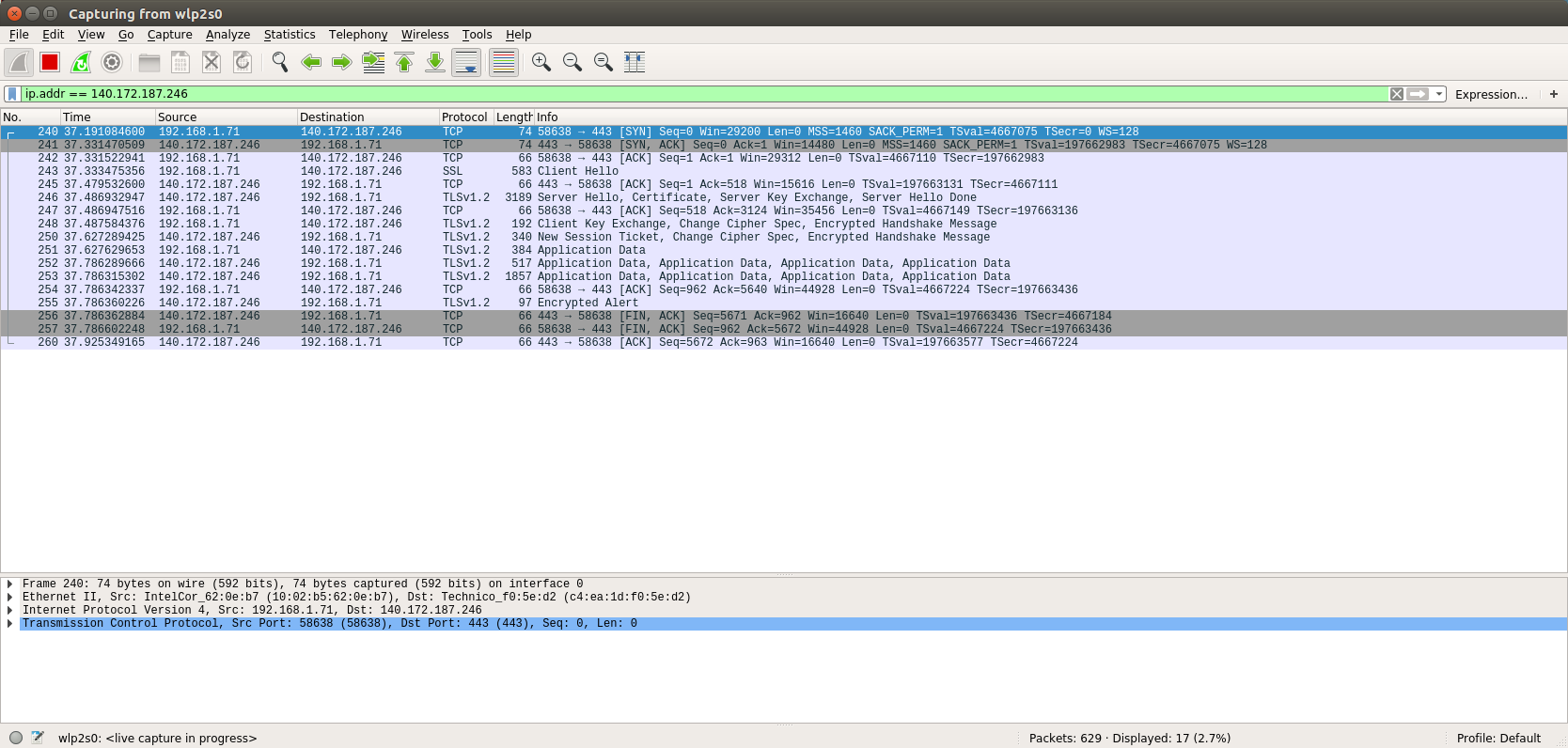
Hi John,
I've captured QGIS packets to/from the WMS service, after clicking
"Connect" on QGIS (to get the capabilities document).
The print screen is available at [1].
Wireshark reports the protocol as TLSv1.2.
Regards,
Jorge
[1] http://webgis.di.uminho.pt/~jgr/qgis-connect-https-wms-service.png
Às 18:23 de 05-01-2017, John Cartwright escreveu:
Thanks.  I used wireshark to trace the session and it appears that QGIS
is attempting to make the connection with TLSv1 which I think is at
least part of the problem.

Can either of you tell me what protocol and cipher suites you’re using?
what OS you’re running on?  Is there anyway to force QGIS to use a
different protocol?

Thanks!

—john
On Jan 4, 2017, at 1:59 AM, Pasquale Di Donato
<pasquale.didon...@gmail.com <mailto:pasquale.didon...@gmail.com>
<mailto:pasquale.didon...@gmail.com>> wrote:
Hi John,
I can access your service too. Using QGIS 2.14.8.
Maybe you have an issue with a proxy?
Pasquale
On Wed, Jan 4, 2017 at 12:57 AM, Jorge Gustavo Rocha
<j...@di.uminho.pt <mailto:j...@di.uminho.pt>
<mailto:j...@di.uminho.pt>> wrote:
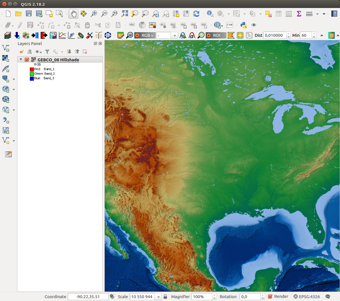
Hi John,
I've added your WMS service and it works without any problem. I've
just added the url and the connect works. The capabilities are
displayed.
You can check the print screen [1] with your https WMS layer.
I'm using QGIS 2.18.2 on Ubuntu. Which OS are you using?
Regards,
Jorge Gustavo
[1] http://webgis.di.uminho.pt/~jgr/wms%20with%20https.png
<http://webgis.di.uminho.pt/~jgr/wms%20with%20https.png>
Às 17:42 de 03-01-2017 <tel:03-01-2017>, John Cartwright escreveu:
Thanks for your reply Luigi! To be clear, the WMS service
that I’m
trying to connect to does not require a username/password but
is only
available via https. The server (https://maps.ngdc.noaa.gov
<https://maps.ngdc.noaa.gov/>) has a
valid CA certificate. I tried adding a SSL Server Configuration
(preferences -> authentication -> Manage Certificates ->
Server) and
while the entry appears to be valid, I still get the SSL
Handshake error
when trying add a WMS layer.
Any further ideas? Here’s the actual URL I’m trying to add:
https://maps.ngdc.noaa.gov/arcgis/services/gebco08_hillshade/MapServer/WMSServer?request=GetCapabilities&service=WMS
<https://maps.ngdc.noaa.gov/arcgis/services/gebco08_hillshade/MapServer/WMSServer?request=GetCapabilities&service=WMS>
Thanks again for your help!
—john
On Jan 2, 2017, at 1:52 AM, Luigi Pirelli
<lui...@gmail.com <mailto:lui...@gmail.com>
<mailto:lui...@gmail.com>
<mailto:lui...@gmail.com <mailto:lui...@gmail.com>>> wrote:
Hi John
SSL is managed storing credentials using the QGIS
Authentication
Manager that store credentials in the same way as Firefox,
in a master
pwd crypted store in your $home/.qgis2/qgis-auth.db.
You should managed credentials using
Settings->options->authentication.
QGIS uses OpenSSL => and specifically can import different
king of
credential method (using plugins => can be expanded). De
default auth
method installed are listed in the documentation:
https://docs.qgis.org/2.14/en/docs/user_manual/auth_system/auth_overview.html
<https://docs.qgis.org/2.14/en/docs/user_manual/auth_system/auth_overview.html>
what is you auth method? can you explain the workflow you
followed to
store and use your credentials?
regards
Luigi Pirelli
**************************************************************************************************
* Boundless QGIS Support/Development: lpirelli AT
boundlessgeo DOT com
* LinkedIn: https://www.linkedin.com/in/luigipirelli
<https://www.linkedin.com/in/luigipirelli>
* Stackexchange:
http://gis.stackexchange.com/users/19667/luigi-pirelli
<http://gis.stackexchange.com/users/19667/luigi-pirelli>
* GitHub: https://github.com/luipir
* Mastering QGIS 2nd Edition:
*
https://www.packtpub.com/big-data-and-business-intelligence/mastering-qgis-second-edition
<https://www.packtpub.com/big-data-and-business-intelligence/mastering-qgis-second-edition>
**************************************************************************************************
On 29 December 2016 at 22:38, John Cartwright
<john.c.cartwri...@comcast.net
<mailto:john.c.cartwri...@comcast.net>
<mailto:john.c.cartwri...@comcast.net>> wrote:
Hello All,
I’m trying to use a WMS service over https and get the
following
error when trying to connect:
Failed to download capabilities:
Download of capabilities failed: SSL handshake failed
The URL works fine in a browser though. I’m guessing
that QGIS and
the server are not able to agree on a cipher suite.
Can anyone tell
me what ciphers QGIS supports or any way to get more
insight into the
underlying problem?
QGIS is version 2.18.2.
Thanks!
—john
_______________________________________________
Qgis-user mailing list
Qgis-user@lists.osgeo.org
<mailto:Qgis-user@lists.osgeo.org>
<mailto:Qgis-user@lists.osgeo.org>
List info:
http://lists.osgeo.org/mailman/listinfo/qgis-user
<http://lists.osgeo.org/mailman/listinfo/qgis-user>
Unsubscribe:
http://lists.osgeo.org/mailman/listinfo/qgis-user
<http://lists.osgeo.org/mailman/listinfo/qgis-user>
_______________________________________________
Qgis-user mailing list
Qgis-user@lists.osgeo.org <mailto:Qgis-user@lists.osgeo.org>
<mailto:Qgis-user@lists.osgeo.org>
List info: http://lists.osgeo.org/mailman/listinfo/qgis-user
<http://lists.osgeo.org/mailman/listinfo/qgis-user>
Unsubscribe: http://lists.osgeo.org/mailman/listinfo/qgis-user
<http://lists.osgeo.org/mailman/listinfo/qgis-user>
J. Gustavo
--
Jorge Gustavo Rocha
Departamento de Informática
Universidade do Minho
4710-057 Braga
Tel: +351 253604480 <tel:%2B351%20253604480>
Fax: +351 253604471 <tel:%2B351%20253604471>
Móvel: +351 910333888 <tel:%2B351%20910333888>
skype: nabocudnosor
_______________________________________________
Qgis-user mailing list
Qgis-user@lists.osgeo.org <mailto:Qgis-user@lists.osgeo.org>
<mailto:Qgis-user@lists.osgeo.org>
List info: http://lists.osgeo.org/mailman/listinfo/qgis-user
<http://lists.osgeo.org/mailman/listinfo/qgis-user>
Unsubscribe: http://lists.osgeo.org/mailman/listinfo/qgis-user
<http://lists.osgeo.org/mailman/listinfo/qgis-user>
_______________________________________________
Qgis-user mailing list
Qgis-user@lists.osgeo.org <mailto:Qgis-user@lists.osgeo.org>
<mailto:Qgis-user@lists.osgeo.org>
List info: http://lists.osgeo.org/mailman/listinfo/qgis-user
Unsubscribe: http://lists.osgeo.org/mailman/listinfo/qgis-user
J. Gustavo
--
Jorge Gustavo Rocha
Departamento de Informática
Universidade do Minho
4710-057 Braga
Tel: +351 253604480
Fax: +351 253604471
Móvel: +351 910333888
skype: nabocudnosor
J. Gustavo
--
Jorge Gustavo Rocha
Departamento de Informática
Universidade do Minho
4710-057 Braga
Tel: +351 253604480
Fax: +351 253604471
Móvel: +351 910333888
skype: nabocudnosor
_______________________________________________
Qgis-user mailing list
Qgis-user@lists.osgeo.org
List info: http://lists.osgeo.org/mailman/listinfo/qgis-user
Unsubscribe: http://lists.osgeo.org/mailman/listinfo/qgis-user