With respect to basins, my understanding is that some of these have water
in them all of the time, some of them have water some of the time, and then
there are some that are almost always dry, but become wet only rarely when
they are needed (e.g. for stormwater handling)
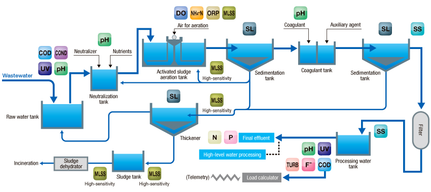
Mappers have used BOTH landuse=basin tag as well as natural=water +
water=basin.  Both methods are documented in the wiki (parallel tagging
scheme).

Should basins be tagged as landuse, water, or both?  Or does it depend on
the type of basin?

On Thu, Dec 17, 2020 at 6:07 PM François Lacombe <fl.infosrese...@gmail.com>
wrote:

>
> Hi Joseph,
>
> Le jeu. 17 déc. 2020 à 20:16, Joseph Eisenberg <joseph.eisenb...@gmail.com>
> a écrit :
>
>> I don't think mappers can know the maximum volume or capacity of a water
>> reservoir or water basin, unless it is written on a public sign somewhere?
>> We can map the surface area, but knowing the average depth or maximum depth
>> is quite difficult, especially when it is not uniform. However for
>> man_made=reservoir_covered and =storage_tank we have capacity=* (in cubic
>> meters?) and content=water/sewage/etc.
>>
>
> volume, elevation would be optional and mostly got from local signage.
> You may have opendata, knowledge or sometimes measurements.
> Many tags are already available but not used at the proper extent.
> For example, if we add capactiy (in cubic meters) on a waste water basin,
> we could do the same for man_made=covered_reservoir or even water=reservoir
> (if information is available somewhere)
> Look at this water tower hunting website giving many details from ground
> http://chateau.deau.free.fr/rdef/PagesHTML/Sommaires/GermanDossiers.html
>
>
>> The usage is not often tagged yet, since this might be hard for a mapper
>> to know.
>>
>
> Regarding waste water basins, it could be useful to distinguish
> - sand traps
> - oil separator
> - floccuation
> - decanter basins
> - aeration tanks
> and so on...
> https://www.horiba.com/fileadmin/_migrated/pics/Wastewater_Processing_E_.jpg
> That looks complex but easilly guessable from aerial imagery or even
> clearly explained during public visits of facilities.
> We could define simpler values if it helps
>
>
>> Currently for landuse=reservoir and water=reservoir this is some use of
>> reservoir_type= - https://wiki.openstreetmap.org/wiki/Key:reservoir_type
>> - with values of water_storage, sewage, tailings, evaporator, tank,
>> salt_pan, wastewater, slurry, irrigation, aquicultura, cooling, etc -
>> though only the first 4 are at all common.
>>
>> basin=* is used with landuse=basin or water=basin to describe the form
>> and function of the basin:
>>
>>    - basin <https://wiki.openstreetmap.org/wiki/Key:basin>=infiltration
>>    <https://wiki.openstreetmap.org/wiki/Tag:basin%3Dinfiltration> - An
>> infiltration
>>    basin <https://en.wikipedia.org/wiki/en:Infiltration_basin> catches
>>    storm water and allows it to seep into an aquifer
>>    <https://en.wikipedia.org/wiki/en:aquifer>.
>>    - basin <https://wiki.openstreetmap.org/wiki/Key:basin>=detention
>>    <https://wiki.openstreetmap.org/wiki/Tag:basin%3Ddetention> - A detention
>>    basin <https://en.wikipedia.org/wiki/en:Detention_basin> catches
>>    storm water and allows it to drain slowly into natural waterways.
>>    - basin <https://wiki.openstreetmap.org/wiki/Key:basin>=retention
>>    <https://wiki.openstreetmap.org/wiki/Tag:basin%3Dretention> - A retention
>>    basin <https://en.wikipedia.org/wiki/en:Retention_basin> catches
>>    storm water and retains it, forming an artificial pond.
>>
>>
>> And note that salt ponds (used to evaporate salt from sea-water) are
>> tagged as landuse <https://wiki.openstreetmap.org/wiki/Key:landuse>=
>> salt_pond <https://wiki.openstreetmap.org/wiki/Tag:landuse%3Dsalt_pond>
>> Pools for swimming are leisure
>> <https://wiki.openstreetmap.org/wiki/Key:leisure>=swimming_pool
>> <https://wiki.openstreetmap.org/wiki/Tag:leisure%3Dswimming_pool>
>>
>> I don't see many combinations with usage=* or another tag that might
>> describe how the reservoir or basin is used, so perhaps this could be
>> proposed?
>>
>
>
> That's right, usage=* corresponds to large familiy of activities and more
> specific tagging would be more suitable to describe precise purpose of a
> particular basin
> reservoir_type and basin looks like to refer to reservoir/basin purpose
> but mixes may concepts that may collide (irrigation is a water_storage as
> well)
> Only some values would match with usage=* ones: usage=irrigation is used
> 12k vs reservoir_type=irrigation 50
>
> Waste water processing could be described with less used water_works=*
> man_made=basin (An artifical structure designed to store some fluid, you
> find basins for storm/rain/radioactive water, sewage, oil, ...)
> content=sewage (Let's put waste water inside)
> usage=industrial (It's part of an industrial process)
> water_works=decanter (It's an actual decanter)
> capacity=xxxx
>
> I'd find great to use water=* with content=water, substance=water or
> natural=water only.
>
> That's my 2 cents, let's refine it
>
> All the best
> François
>
> _______________________________________________
> Tagging mailing list
> Tagging@openstreetmap.org
> https://lists.openstreetmap.org/listinfo/tagging
>
_______________________________________________
Tagging mailing list
Tagging@openstreetmap.org
https://lists.openstreetmap.org/listinfo/tagging