On 17/08/2015 23:25, Rob Nickerson wrote:
So far there is little interest to do this on the OSM default render
style which seems odd to me given how much fuss there has been on this
list to recent changes to the footway/path style (over the last year)!
There's no interest to do this in the OSM "standard" style because it is
abundantly clear that any new attempts at changes that make rural
navigation possible* in OSM-carto would be rejected based on the ones
that already have been over the last year. Although it hasn't been
explicitly stated, the direction of travel of that style is clear - some
people want a map style that's useful for navigation, others want
something that "looks nice"; based on comments on the issues raised it's
clear that the people maintaining the style are in the latter group
rather than the former. This isn't a solvable problem; one map style
can't be useful for different purposes** with conflicting requirements,
render _everything_ in order to be a useful part of the feedback loop
and also be a "nice looking map". The current discussion about
rendering surface on footpaths in OSM-carto is essentially a waste of
time if you can't see the paths themselves at all at a zoom level you'd
use for planning a route over them.
I suspect that a number of people have just stopped using the "standard"
style altogether and are now using something else instead, whether
that's OSM's "cycle map" style (a number of help and IRC questions get
asked where people just assume that "everybody uses" that), OsmAnd
internal styles, cycle.travel, or whatever. I just stick my own tiles
in in place of the MapQuest Open ones and use those.
Cheers,

Andy
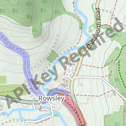
* Seriously - if you wanted a nice walk in the Peak District, could you
really use http://a.tile.openstreetmap.org/14/8118/5322.png to plan
where you're going? It's simply not fit for purpose when compared to
http://a.tile.thunderforest.com/cycle/14/8118/5322.png ,
http://tile.cycle.travel/topoclassical/14/8118/5322.png or
http://i.imgur.com/hvCHgFW.png .
** In addition to OSM-carto we've got 2 good but different options for
cycling, various bus options including "Transport" on the mail osm.org
layer switcher, for now at least we've got Mapquest open for car route
planning, and I'd argue that my style is a good option for
England-and-Wales footpaths (though you'd need to render your own tiles
to use it). What we're missing (of the major transport types) is
something targeted at horseriders, and probably most importantly for
mappers a "complete but ugly" style to replace the long-departed OsmaRender.
_______________________________________________
Talk-GB mailing list
Talk-GB@openstreetmap.org
https://lists.openstreetmap.org/listinfo/talk-gb