Hi Ronny,
for the refs that are not implemented yet (ie no signs on the road), you could
convert to ref:phThis way, it would keep the reference and it would be easy
later to convert back.
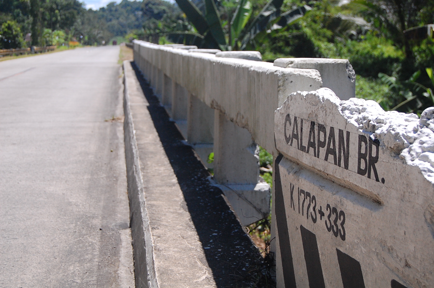
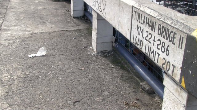
On the map, both the ref and the road name are showed. I am not sure that the name will be showed by the routing applications if you remove the ref. You will see the result if you look at areas where there is no ref. About the roundabout in the calculator, we see in this link that small segments with no names are reported as unamed. http://www.openstreetmap.org/directions?engine=osrm_car&route=15.1653%2C120.6177%3B15.2239%2C120.5914#map=20/15.16086/120.60972&layers=H You could try to discuss on the osm main list about this reporting how this new routing feature could be enhanced. Pierre De : Ronny Ager-Wick <ro...@ager-wick.com> À : Pierre Béland <pierz...@yahoo.fr>; Eugene Alvin Villar <sea...@gmail.com> Cc : OSM-PH <talk-ph@openstreetmap.org> Envoyé le : Mercredi 18 février 2015 22h01 Objet : Re: [talk-ph] Tagging bridges and tunnels Hi, Pierre, Thanks for the reply. It seems to me that when a road has a ref tag, the itinerary calculator generally ignores street names, including the one given to the Abacan Bridge. This may make sense in Europe and the US, but here it's actually quite confusing. The ref (R-9 fo MacArthur Highway) is generally not used outside of the mapping community, and hardly within I believe. If I ask 500 random people on the street in Angeles City where R-9 or R-8 is, I doubt a single one would know. Furthermore, I can't remember seeing a single sign along a road stating the ref. The ideal displayed name for this road would be "MacArthur Highway" - that's what everyone calls it. Same for R-9, which is known as "NLEX", or simply "the expressway". Is there a way to make that happen, but still not tag for display purposes? Could we simply remove the ref tag entirely, maybe renaming it to "future_ref" or something awaiting the local government actually putting up signs so that people are aware of it (likely to take decades)? If we're supposed to map reality, the ref tag, at least outside of Metro Manila, does not reflect it at the moment. Also, the itinerary calculator unfortunately doesn't seem to handle roundabouts very well. Or are they incorrectly tagged? If I was to give that itinerary description to someone, I am sure they would get lost, as I can hardly think of a more complicated way to describe an essentially straight piece of road. Knowing I might have been tagging incorrectly in this area myself, is there any way we could tag this differently to improve the routing? Ideally this stretch would be described as: Follow MacArthur Highway Turn slight right onto Abacan Bridge Turn slight left onto MacArthur Highway (or better, "Take 3rd exit in the roundabout onto MacArthur Highway", but this may be hard if the routing software doesn't know it's a roundabout...) Reach destination. Ronny. On 2015-02-19 09:33, Pierre Béland wrote: Hi Ronny, I thought of using the new itinary calculation crossing the Abacan bridge. I can see from the map in this area that in Philippines, like elsewhere, ref tag is used for roads (here ref=R-9). See the link for the itinary http://www.openstreetmap.org/directions?engine=osrm_car&route=15.1682%2C120.5893%3B15.1426%2C120.5962#map=15/15.1554/120.5929 With OSRM, it does show the ref-R-9 but do not report bridge crossing. With Mapquest, there is even less info. I wonder if OSMAnd on Android or any other road calculation software would report bridge crossing. Pierre De : Ronny Ager-Wick <ro...@ager-wick.com> À : Eugene Alvin Villar <sea...@gmail.com>; Pierre Béland <pierz...@yahoo.fr> Cc : OSM-PH <talk-ph@openstreetmap.org> Envoyé le : Mercredi 18 février 2015 20h18 Objet : Re: [talk-ph] Tagging bridges and tunnels This is a good point Eugene, and in fact the bridge names are very good landmarks, given that there are not many other signs on the roads in the Philippines, especially in rural areas. Another thing to take into consideration is that many bridges gain their name from the river they cross over, so there may be many bridges with the same name. They are definitely not tagged consistently at the moment, for example: http://www.openstreetmap.org/#map=17/15.15516/120.59219 http://www.openstreetmap.org/#map=17/15.15840/120.60712 If I remember correctly, they are both named Abacan Bridge, but only one of them has that name on the map, and incidentally the one with a different road name on each side does not. Do you know if common routing software will pick up the bridge:name=* tag? Yes, I know we're not supposed to tag based on what current software will pick up, but it is interesting to know, given that bridges are such great landmarks. It would be great with a published suggested standard that fits the Philippine conditions. Ronny. On 2015-02-19 08:08, Eugene Alvin Villar wrote: Hi Pierre, Most bridges here in the Philippines have names no matter how small. You can usually spot their name on the guard rail or on a small sign just before the bridge. These names are almost always accompanied by the maximum load the bridge can handle (which is tagged using maxweight=*) and sometimes with the distance from the island's zero-kilometer marker (I have no idea how to tag these. Maybe distance=*?). Some examples: http://www.philippinesdailyphotos.com/wp-content/uploads/2009/04/bukidnon-atugan-bridge.jpg http://www.zamboanga.com/z/images/0/09/Calapan_Bridge,_Calapan,_Kabasalan,_Zamboanga_Sibugay,_Philippines.JPG http://static.rappler.com/images/tullahan-bridge-screengrab-20130708.jpg Regards, Eugene On Thu, Feb 19, 2015 at 1:59 AM, Pierre Béland <pierz...@yahoo.fr> wrote: Eugene, I expect that only the major bridges have name. And we generally refer to these by their name and not the road reference. Unless you have particularities in Philippines. Example Golden Gate Bridge in San Francisco bay. OpenStreetMap | Golden Gate Bridge (52477381) Pierre De : Eugene Alvin Villar <sea...@gmail.com> À : Ervin Malicdem <schad...@gmail.com> Cc : OSM-PH <talk-ph@openstreetmap.org> Envoyé le : Mercredi 18 février 2015 12h35 Objet : Re: [talk-ph] Tagging bridges and tunnels Hi Ervin, Option 1 is what I do. Take note that if we have a way with highway=something and bridge=yes, then the object is primarily a highway/road and the bridge is only an aspect or property of the highway/road segment. Therefore, the name=* tag should be the name of the highway/road. And then put the name of the bridge on the bridge:name=* tag. Besides, it will be very weird to have a long highway with unconnected names just because there are bridges along the highway. The only time I would put the name of the bridge on the name=* tag is if the roads from both ends of the bridge have different names. For example, the bridge formerly called Del Pan in Manila: www.openstreetmap.org/way/4304674 ~Eugene On Wed, Feb 18, 2015 at 5:34 PM, Ervin Malicdem <schad...@gmail.com> wrote: Query regarding tagging bridges. What is the appropriate way of tagging bridges? Option1: Use the name of the road, and place the name of the bridge under bridge:name or the name of the tunnel under tunnel:name Option2: Use the name of the bridge/tunnel, omit the road name Thanks Ervin M. Schadow1 Expeditions - A Filipino must not be a stranger to his own motherland. http://www.s1expeditions.com _______________________________________________ talk-ph mailing list talk-ph@openstreetmap.org https://lists.openstreetmap.org/listinfo/talk-ph _______________________________________________ talk-ph mailing list talk-ph@openstreetmap.org https://lists.openstreetmap.org/listinfo/talk-ph _______________________________________________ talk-ph mailing list talk-ph@openstreetmap.org https://lists.openstreetmap.org/listinfo/talk-ph
_______________________________________________
talk-ph mailing list
talk-ph@openstreetmap.org
https://lists.openstreetmap.org/listinfo/talk-ph