On 2013-10-14 10:42 AM, Martijn van Exel wrote:
So what are we talking about? Intersections like this one, where one
or more dual carriageways come together at an at-grade intersection:
https://www.evernote.com/shard/s9/sh/6438c196-bb92-4f66-81dc-9b75186286ba/0e8f07ff527c6a85c0dec426b9b79f1e

One of my colleagues at Telenav has remapped this intersection as follows:

https://www.evernote.com/shard/s9/sh/3491f1fe-6afa-4571-bc43-7cb31c9c2625/9dd47d1445fdcf03d3f0bbd93b8e0f92

The main difference, and the source of some feedback we have received
over the past few days, is that the dual carriageway roads are
straightened out, creating multiple intersection nodes (4 in this
case) instead of the original single intersection node that connects
all the incoming and outgoing ways. That technique turns out to yield
more reliable and correct routing and guidance ('keep left, turn
right') through these intersections in our testing. But of course,
that cannot dictate how we map as a community, so let's discuss.
I'm one of the troublemakers who complained about your colleague's
edits. However, the example you give bears little resemblance to the
intersections I disagree on. Your "before" screenshot depicts individual
lanes (ew) that converge into a single-point intersection, even when the
main road is divided on both sides of the intersection (ew). My quibble
relates to divided roads that become undivided at an intersection.
Screenshots tell it best, but unfortunately we don't seem to have a tool
to visualize historical revisions of ways. So I recreated their changes
from memory in iD (because that's how I roll).
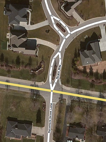
** Example A **
Ryans Way and Sycamore Grove Ln. meet Fields Ertel Rd. at the same
intersection. Fields Ertel is undivided. Ryans Way is briefly divided at
the subdivision entrance, a very common configuration in newer
subdivisions, but Sycamore Grove is not.
I mapped the intersection as a single point:

<http://nguyen.cincinnati.oh.us/minh/osm/talk-us/braided_intersections/ryans_before.png>
Your colleague redrew it as a two-point intersection, dividing the very
tip of Sycamore Grove (to the south):
<http://nguyen.cincinnati.oh.us/minh/osm/talk-us/braided_intersections/ryans_after.png>
I prefer the former approach, because the latter shows a false traffic
island on the south side of the intersection. Imagine a pedantic
navigation tool that tells a driver coming from Sycamore Grove to
"keep/bear right and immediately turn left".
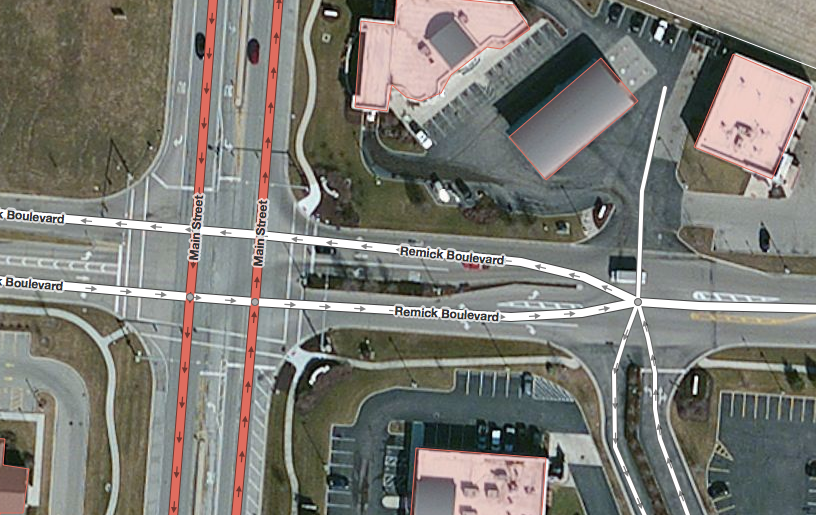
** Example B **
A divided Main St. intersects a divided Remick Blvd. Like everyone else
here -- and unlike the "before" example Martijn provided -- I prefer a
four-point intersection. But just to the east, Remick and a service road
both become undivided at the same intersection. I mapped it as a single
point:
<http://nguyen.cincinnati.oh.us/minh/osm/talk-us/braided_intersections/remick_before.png>
Your colleague redrew it as a four-point intersection, this time with
two triangles:
<http://nguyen.cincinnati.oh.us/minh/osm/talk-us/braided_intersections/remick_after.png>

** Example C **
Originally, State Route 4 became undivided at an intersection with
Walden Ponds Cir. (divided) and Fairham Rd. (undivided). SR 4, with a
speed limit of at least 45 mph, was redrawn to shuffle about 25 feet to
the left right after the intersection. But on major roads like SR 4, the
landscaped median ends several hundred feet before the intersection to
make room for a long left-turn lane. So I prefer to join the
carriageways atop the left-turn lane, at a much gentler angle, without
cutting into the median.
Since I first mapped the area, the median on SR 4 was extended well past
this intersection, so no "braiding" was necessary:
<http://osm.org/browse/way/240893333>
In all three examples, my original rendition was called "braiding", but
the ways were never intertwined as in the much-ridiculed TIGER data.
I don't know what specific issues you found with the way I'd been
mapping. But I think routers should handle both styles gracefully,
because mappers will intuitively gravitate towards one or the other,
depending on what factors they consider. As intersections go, these
examples are rather straightforward. On the other hand, I've mapped
plenty of intersections where the traffic engineers clearly got carried
away. If someone corrects me on one of those, I'm all ears! :-)
<http://osm.org/browse/relation/1843583>
<http://osm.org/browse/relation/1284976>
<http://osm.org/go/ZR~9kObUM>

--
m...@nguyen.cincinnati.oh.us


_______________________________________________
Talk-us mailing list
Talk-us@openstreetmap.org
https://lists.openstreetmap.org/listinfo/talk-us