Hi Minh -

Thanks for clarifying the more specific cases. I realize that my
example would not cover all the possible permutations. Thank you for
bringing more specific cases to the table. My colleague Kristen also
has some more specific examples I know she intends to share here. Your
specific cases actually make a lot of sense to me. I want to discuss
this with my colleagues and get their opinions as well.
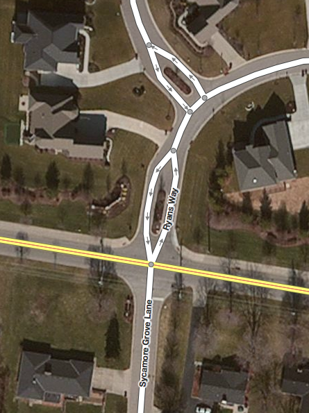
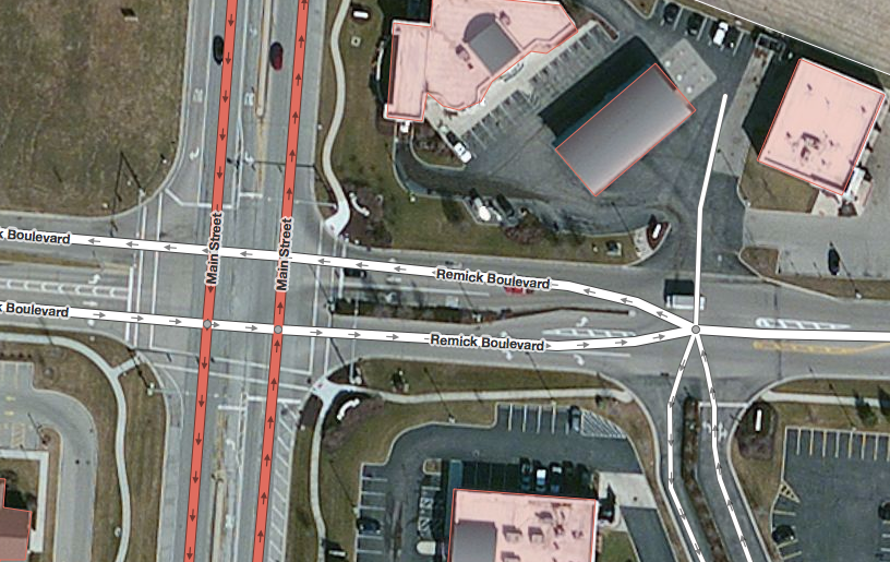
I apologize for the confusion around the term 'braiding' - we used
this term internally for a while (and it ended up in some changeset
comments) not realizing that this had a different meaning that traces
back to the TIGER source data.

Thank you for your feedback!

On Tue, Oct 15, 2013 at 3:51 AM, Minh Nguyen
<m...@nguyen.cincinnati.oh.us> wrote:
> On 2013-10-14 10:42 AM, Martijn van Exel wrote:
>>
>> So what are we talking about? Intersections like this one, where one
>> or more dual carriageways come together at an at-grade intersection:
>>
>>
>> https://www.evernote.com/shard/s9/sh/6438c196-bb92-4f66-81dc-9b75186286ba/0e8f07ff527c6a85c0dec426b9b79f1e
>>
>> One of my colleagues at Telenav has remapped this intersection as follows:
>>
>>
>> https://www.evernote.com/shard/s9/sh/3491f1fe-6afa-4571-bc43-7cb31c9c2625/9dd47d1445fdcf03d3f0bbd93b8e0f92
>>
>> The main difference, and the source of some feedback we have received
>> over the past few days, is that the dual carriageway roads are
>> straightened out, creating multiple intersection nodes (4 in this
>> case) instead of the original single intersection node that connects
>> all the incoming and outgoing ways. That technique turns out to yield
>> more reliable and correct routing and guidance ('keep left, turn
>> right') through these intersections in our testing. But of course,
>> that cannot dictate how we map as a community, so let's discuss.
>
>
> I'm one of the troublemakers who complained about your colleague's edits.
> However, the example you give bears little resemblance to the intersections
> I disagree on. Your "before" screenshot depicts individual lanes (ew) that
> converge into a single-point intersection, even when the main road is
> divided on both sides of the intersection (ew). My quibble relates to
> divided roads that become undivided at an intersection.
>
> Screenshots tell it best, but unfortunately we don't seem to have a tool to
> visualize historical revisions of ways. So I recreated their changes from
> memory in iD (because that's how I roll).
>
>
>
> ** Example A **
>
> Ryans Way and Sycamore Grove Ln. meet Fields Ertel Rd. at the same
> intersection. Fields Ertel is undivided. Ryans Way is briefly divided at the
> subdivision entrance, a very common configuration in newer subdivisions, but
> Sycamore Grove is not.
>
> I mapped the intersection as a single point:
>
> <http://nguyen.cincinnati.oh.us/minh/osm/talk-us/braided_intersections/ryans_before.png>
>
> Your colleague redrew it as a two-point intersection, dividing the very tip
> of Sycamore Grove (to the south):
>
> <http://nguyen.cincinnati.oh.us/minh/osm/talk-us/braided_intersections/ryans_after.png>
>
> I prefer the former approach, because the latter shows a false traffic
> island on the south side of the intersection. Imagine a pedantic navigation
> tool that tells a driver coming from Sycamore Grove to "keep/bear right and
> immediately turn left".
>
> ** Example B **
>
> A divided Main St. intersects a divided Remick Blvd. Like everyone else here
> -- and unlike the "before" example Martijn provided -- I prefer a four-point
> intersection. But just to the east, Remick and a service road both become
> undivided at the same intersection. I mapped it as a single point:
>
> <http://nguyen.cincinnati.oh.us/minh/osm/talk-us/braided_intersections/remick_before.png>
>
> Your colleague redrew it as a four-point intersection, this time with two
> triangles:
>
> <http://nguyen.cincinnati.oh.us/minh/osm/talk-us/braided_intersections/remick_after.png>
>
> ** Example C **
>
> Originally, State Route 4 became undivided at an intersection with Walden
> Ponds Cir. (divided) and Fairham Rd. (undivided). SR 4, with a speed limit
> of at least 45 mph, was redrawn to shuffle about 25 feet to the left right
> after the intersection. But on major roads like SR 4, the landscaped median
> ends several hundred feet before the intersection to make room for a long
> left-turn lane. So I prefer to join the carriageways atop the left-turn
> lane, at a much gentler angle, without cutting into the median.
>
> Since I first mapped the area, the median on SR 4 was extended well past
> this intersection, so no "braiding" was necessary:
>
> <http://osm.org/browse/way/240893333>
>
>
>
> In all three examples, my original rendition was called "braiding", but the
> ways were never intertwined as in the much-ridiculed TIGER data.
>
> I don't know what specific issues you found with the way I'd been mapping.
> But I think routers should handle both styles gracefully, because mappers
> will intuitively gravitate towards one or the other, depending on what
> factors they consider. As intersections go, these examples are rather
> straightforward. On the other hand, I've mapped plenty of intersections
> where the traffic engineers clearly got carried away. If someone corrects me
> on one of those, I'm all ears! :-)
>
> <http://osm.org/browse/relation/1843583>
> <http://osm.org/browse/relation/1284976>
> <http://osm.org/go/ZR~9kObUM>
>
> --
> m...@nguyen.cincinnati.oh.us
>
>
> _______________________________________________
>
> Talk-us mailing list
> Talk-us@openstreetmap.org
> https://lists.openstreetmap.org/listinfo/talk-us

_______________________________________________
Talk-us mailing list
Talk-us@openstreetmap.org
https://lists.openstreetmap.org/listinfo/talk-us