I'm going to bow out of this discussion.  The boundary relation is
broken again.  I'm not trying to be confrontational, but my attempts to
figure out what sources this user is using and to reconcile this with
what they are editing appear to be antagonizing them.  I have also lost
my patience so I will probably not be the most understanding anymore.
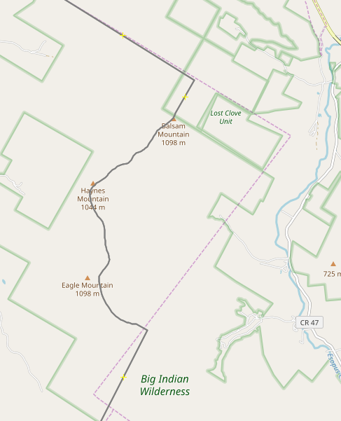
James

On Tue, 2020-08-18 at 20:23 -0400, Kevin Kenny wrote:
> You still aren't giving us very much to go on.  There's obviously
> some boundary that you consider to be inarguably correct. You need
> either to enter the data yourself or tell us where to find it and
> where the discrepancies are.
>
> Sometimes that involves quite a lot of research. I have a ton of data
> conflicts about boundaries near me, and only rarely do I have the
> time to pursue the issues. If often involves reconciling half a dozen
> supposedly authoritative sources, as shown in
> https://www.openstreetmap.org/user/ke9tv/diary/391486.  It's very
> rarely as simple as 'agency X is wrong and agency Y is right'. It's
> often 'agency X has lines that reflect current annexation, but part
> of their boundary is in NAD27 and part WGS84. Agency Y misses a
> recent annexation but has got the datums right. Agency Z has the
> artificial lines right, but is totally off base with the shorelines.
> Agency W appears to have digitized from a small-scale map and has a
> ton of quantization error.'
>
> It's not a political boundary, but
> https://www.openstreetmap.org/user/ke9tv/diary/42951 shows another
> example of the level of cadastral research that's often required to
> sort these things out.
>
> By the way, I _do_ occasionally go out into the field and try to
> recover old survey marks to sort these things out.  For the
> inconsistent corner between Lost Clove Unit and Big Indian Wilderness
> at https://kbk.is-a-geek.net/attachments/20191205/osm-vs-nysgis.png I
> simply gave up. There are cairns at both corners. If the professional
> surveyors couldn't close the line, what hope do I have? (Nobody
> actually cares. It's wilderness anyway.)
>
> On Tue, Aug 18, 2020 at 8:03 PM 80hnhtv4agou--- via Talk-us <
> talk-us@openstreetmap.org> wrote:
> > FYI;
> >
> > for all of you who are not in country and do not understand about
> > usa city bounders.
> >
> > https://www.census.gov/programs-surveys/geography/contact.html
> >
> > and did you read what the other guy said, this is the census data
> > not true map data.
> >
> > https://www.openstreetmap.org/changeset/89598349.
> >
> > > Tuesday, August 18, 2020 10:52 AM -05:00 from James Umbanhowar <
> > > jumba...@gmail.com>:
> > >
> > > What link are you using for this? I downloaded the places
> > > boundary
> > > information from here:
> > > https://www.census.gov/cgi-bin/geo/shapefiles/index.php
> > >
> > > As I said, I'm happy to change, but I can't change without actual
> > > information.
> > >
> > > On Tue, 2020-08-18 at 18:43 +0300, 80hnhtv4agou--- via Talk-us
> > > wrote:
> > > > i am looking at the TIRGER web, show’s the real map online and
> > > > nothing you did matches.
> > > >
> > > > i live here and a block away from the edens spur just saying.
> > > >
> > > > > Tuesday, August 18, 2020 10:38 AM -05:00 from James
> > > Umbanhowar <
> > > > > jumba...@gmail.com>:
> > > > >
> > > > > It would probably be best if these suggestions were added in
> > > the
> > > > > changeset comments, as they don't need to be discussed on the
> > > > > mailing
> > > > > list.
> > > > >
> > > > > On Tue, 2020-08-18 at 11:36 -0400, James Umbanhowar wrote:
> > > > > > I'm the person who made the changes and am happy to adjust
> > > the
> > > > > map to
> > > > > > better authoritative data or information. My motivation for
> > > this
> > > > > was
> > > > > > to fix a mangled boundary relation that didn't have
> > > consistent
> > > > > outer
> > > > > > and inner members. The changes came in two changesets,
> > > > > > https://www.openstreetmap.org/changeset/89220282 and
> > > > > > https://www.openstreetmap.org/changeset/89516909
> > > > > >
> > > > > > The first changeset just made the relation consistent with
> > > outer
> > > > > ways
> > > > > > and inner ways. I preserved all the ways that were in the
> > > > > relation
> > > > > > that
> > > > > > lead to the inconsistency and they are still in the
> > > database with
> > > > > a
> > > > > > note attached to them. The second came after a changeset
> > > comment
> > > > > that
> > > > > > noted that the fixed relation didn't match and earlier
> > > unbroken
> > > > > > relation, in particular around the Edens Spur. I then
> > > changed the
> > > > > > border in this area to match the 2019 Tiger data in that
> > > area
> > > > > only.
> > > > > >
> > > > > > James
> > > > > >
> > > > > > On Tue, 2020-08-18 at 02:37 +0300, 80hnhtv4agou--- via
> > > Talk-us
> > > > > wrote:
> > > > > > > Changeset #89220282
> > > > > > >
> > > > > > >
> > > > > > > > Monday, August 17, 2020 6:34 PM -05:00 from Mike
> > > Thompson <
> > > > > > > > miketh...@gmail.com>:
> > > > > > > >
> > > > > > > >
> > > > > > > >
> > > > > > > > On Mon, Aug 17, 2020 at 5:24 PM 80hnhtv4agou--- via
> > > Talk-us <
> > > > > > > > talk-us@openstreetmap.org> wrote:
> > > > > > > > > tiger is up to date on the web map using the current
> > > data i
> > > > > > > > > just
> > > > > > > > > think he picked the wrong year,
> > > > > > > >
> > > > > > > > That relation was first created in 2009. According to
> > > the
> > > > > source
> > > > > > > > tag, it used 2008 Tiger data, so the original mapper
> > > probably
> > > > > > > > used
> > > > > > > > the best available TIGER data at the time.
> > > > > > > >
> > > > > > > > >
> > > > > > > > > also all he got was a white line in his first try.
> > > > > > > > > Way: 813726663
> > > > > > > >
> > > > > > > > That way needs to be added to the relation, and the
> > > relation
> > > > > must
> > > > > > > > close.
> > > > >
> >
> >
> >
> > _______________________________________________
> > Talk-us mailing list
> > Talk-us@openstreetmap.org
> > https://lists.openstreetmap.org/listinfo/talk-us
>
>
> _______________________________________________
> Talk-us mailing list
> Talk-us@openstreetmap.org
> https://lists.openstreetmap.org/listinfo/talk-us


_______________________________________________
Talk-us mailing list
Talk-us@openstreetmap.org
https://lists.openstreetmap.org/listinfo/talk-us