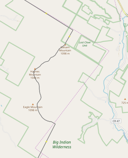
i will fix anything that i missed but the lines are truth.

and it is not a polygon, and i broke nothing i fixed what the other guy broke
and did it all by hand.

>Tuesday, August 18, 2020 7:36 PM -05:00 from James Umbanhowar
><jumba...@gmail.com>:
>
>I'm going to bow out of this discussion. The boundary relation is
>broken again. I'm not trying to be confrontational, but my attempts to
>figure out what sources this user is using and to reconcile this with
>what they are editing appear to be antagonizing them. I have also lost
>my patience so I will probably not be the most understanding anymore.
>
>James
>
>On Tue, 2020-08-18 at 20:23 -0400, Kevin Kenny wrote:
>> You still aren't giving us very much to go on. There's obviously
>> some boundary that you consider to be inarguably correct. You need
>> either to enter the data yourself or tell us where to find it and
>> where the discrepancies are.
>>
>> Sometimes that involves quite a lot of research. I have a ton of data
>> conflicts about boundaries near me, and only rarely do I have the
>> time to pursue the issues. If often involves reconciling half a dozen
>> supposedly authoritative sources, as shown in
>>  https://www.openstreetmap.org/user/ke9tv/diary/391486 . It's very
>> rarely as simple as 'agency X is wrong and agency Y is right'. It's
>> often 'agency X has lines that reflect current annexation, but part
>> of their boundary is in NAD27 and part WGS84. Agency Y misses a
>> recent annexation but has got the datums right. Agency Z has the
>> artificial lines right, but is totally off base with the shorelines.
>> Agency W appears to have digitized from a small-scale map and has a
>> ton of quantization error.'
>>
>> It's not a political boundary, but
>>  https://www.openstreetmap.org/user/ke9tv/diary/42951 shows another
>> example of the level of cadastral research that's often required to
>> sort these things out.
>>
>> By the way, I _do_ occasionally go out into the field and try to
>> recover old survey marks to sort these things out. For the
>> inconsistent corner between Lost Clove Unit and Big Indian Wilderness
>> at  https://kbk.is-a-geek.net/attachments/20191205/osm-vs-nysgis.png I
>> simply gave up. There are cairns at both corners. If the professional
>> surveyors couldn't close the line, what hope do I have? (Nobody
>> actually cares. It's wilderness anyway.)
>>
>> On Tue, Aug 18, 2020 at 8:03 PM 80hnhtv4agou--- via Talk-us <
>>  talk-us@openstreetmap.org > wrote:
>> > FYI;
>> >
>> > for all of you who are not in country and do not understand about
>> > usa city bounders.
>> >
>> >  https://www.census.gov/programs-surveys/geography/contact.html
>> >
>> > and did you read what the other guy said, this is the census data
>> > not true map data.
>> >
>> >  https://www.openstreetmap.org/changeset/89598349 .
>> >
>> > > Tuesday, August 18, 2020 10:52 AM -05:00 from James Umbanhowar <
>> > >  jumba...@gmail.com >:
>> > >
>> > > What link are you using for this? I downloaded the places
>> > > boundary
>> > > information from here:
>> > >  https://www.census.gov/cgi-bin/geo/shapefiles/index.php
>> > >
>> > > As I said, I'm happy to change, but I can't change without actual
>> > > information.
>> > >
>> > > On Tue, 2020-08-18 at 18:43 +0300, 80hnhtv4agou--- via Talk-us
>> > > wrote:
>> > > > i am looking at the TIRGER web, show’s the real map online and
>> > > > nothing you did matches.
>> > > >
>> > > > i live here and a block away from the edens spur just saying.
>> > > >
>> > > > > Tuesday, August 18, 2020 10:38 AM -05:00 from James
>> > > Umbanhowar <
>> > > > >  jumba...@gmail.com >:
>> > > > >
>> > > > > It would probably be best if these suggestions were added in
>> > > the
>> > > > > changeset comments, as they don't need to be discussed on the
>> > > > > mailing
>> > > > > list.
>> > > > >
>> > > > > On Tue, 2020-08-18 at 11:36 -0400, James Umbanhowar wrote:
>> > > > > > I'm the person who made the changes and am happy to adjust
>> > > the
>> > > > > map to
>> > > > > > better authoritative data or information. My motivation for
>> > > this
>> > > > > was
>> > > > > > to fix a mangled boundary relation that didn't have
>> > > consistent
>> > > > > outer
>> > > > > > and inner members. The changes came in two changesets,
>> > > > > >  https://www.openstreetmap.org/changeset/89220282 and
>> > > > > >  https://www.openstreetmap.org/changeset/89516909
>> > > > > >
>> > > > > > The first changeset just made the relation consistent with
>> > > outer
>> > > > > ways
>> > > > > > and inner ways. I preserved all the ways that were in the
>> > > > > relation
>> > > > > > that
>> > > > > > lead to the inconsistency and they are still in the
>> > > database with
>> > > > > a
>> > > > > > note attached to them. The second came after a changeset
>> > > comment
>> > > > > that
>> > > > > > noted that the fixed relation didn't match and earlier
>> > > unbroken
>> > > > > > relation, in particular around the Edens Spur. I then
>> > > changed the
>> > > > > > border in this area to match the 2019 Tiger data in that
>> > > area
>> > > > > only.
>> > > > > >
>> > > > > > James
>> > > > > >
>> > > > > > On Tue, 2020-08-18 at 02:37 +0300, 80hnhtv4agou--- via
>> > > Talk-us
>> > > > > wrote:
>> > > > > > > Changeset #89220282
>> > > > > > >
>> > > > > > >
>> > > > > > > > Monday, August 17, 2020 6:34 PM -05:00 from Mike
>> > > Thompson <
>> > > > > > > >  miketh...@gmail.com >:
>> > > > > > > >
>> > > > > > > >
>> > > > > > > >
>> > > > > > > > On Mon, Aug 17, 2020 at 5:24 PM 80hnhtv4agou--- via
>> > > Talk-us <
>> > > > > > > >  talk-us@openstreetmap.org > wrote:
>> > > > > > > > > tiger is up to date on the web map using the current
>> > > data i
>> > > > > > > > > just
>> > > > > > > > > think he picked the wrong year,
>> > > > > > > >
>> > > > > > > > That relation was first created in 2009. According to
>> > > the
>> > > > > source
>> > > > > > > > tag, it used 2008 Tiger data, so the original mapper
>> > > probably
>> > > > > > > > used
>> > > > > > > > the best available TIGER data at the time.
>> > > > > > > >
>> > > > > > > > >
>> > > > > > > > > also all he got was a white line in his first try.
>> > > > > > > > > Way:  813726663
>> > > > > > > >
>> > > > > > > > That way needs to be added to the relation, and the
>> > > relation
>> > > > > must
>> > > > > > > > close.
>> > > > >
>> >
>> >
>> >
>> > _______________________________________________
>> > Talk-us mailing list
>> >  Talk-us@openstreetmap.org
>> >  https://lists.openstreetmap.org/listinfo/talk-us
>>
>>
>> _______________________________________________
>> Talk-us mailing list
>>  Talk-us@openstreetmap.org
>>  https://lists.openstreetmap.org/listinfo/talk-us
>
>_______________________________________________
>Talk-us mailing list
>Talk-us@openstreetmap.org
>https://lists.openstreetmap.org/listinfo/talk-us
_______________________________________________
Talk-us mailing list
Talk-us@openstreetmap.org
https://lists.openstreetmap.org/listinfo/talk-us