Two things come to my mind:

1. I also often use aven to assist my drawing. What helps me alot here is
linux/kde, because I can do stuff in aven, put the window below xtherions and
make the xtherion window  transparent. Aven works as a kind of „background
image“ in that regard.
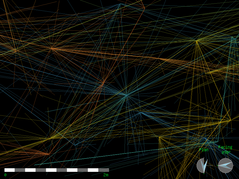
2. when drawing vertically, isn‘t drawing (and rendering)  exendet elevations
far more useful and expressive?
You also can export xvis in that projection.


> Am 28.01.2025 um 17:17 schrieb Tarquin Wilton-Jones via Therion
> <[email protected]>:
>
> Hi Jean-Florent,
>
>> I am drawing the map of a cave that is so far mostly vertical. In the map
>> editor of xtherion is very hard to distinguish which lines / stations of the
>> xvi belong to which part of the cave, because they are all drawn over each
>> other when seen from above. When adding walls and objects it becomes even
>> worse.
>
>
> In general, I can say "me too". We had this exact same issue. We kept our
> surveys short, so there were not too many stations overlapping. This was also
> important when gathering the data, though SexyTopo is actually very helpful
> there, and highlights the "current station" and its splays (this feature was
> added specifically because of our needs while surveying). I would dearly love
> something similar in XTherion...
>
> This is part of our survey, where 10 passages overlap, within a vertical
> range of just 62 metres;
> https://www.cavinguk.co.uk/pwlldwfn/pwlldwfnarticle/normal/Chaos.png
> XTherion shows this as a grey jumbled mass of nonsense. Shorter surveys
> really, really helps to keep the noise down. However, it is often hard to
> find a convenient place to end a survey in a really vertical cave, and you
> end up giving yourself a load of ugly "join" commands to make up for it.
>
> In these situations, XTherion seems to expect you to have drawn perfect lines
> in the cave, so you don't have to rely on the splays.
>
>> Is there an easy way to deal with this? Maybe generating different xvi's for
>> the different levels in the cave and drawing the scraps in different th2
>> files?
>
>
> I don't worry about the drawn scraps, since they feel unimportant when not
> focused. I worry more about "which splay am I trying to touch with this
> line". We used Survex Aven to render the .3d output, click to focus a splay
> end, and repeatedly flick from plan (P) to elevation (E) to see the splays
> move, and work out which one ended up where in the plan view, then try to
> locate that same splay in XTherion. It was very helpful being able to have
> the two apps running on two screens at the same time, to compare them. Aven
> makes things a lot more easy to see. Loch does not have any useful splay
> focusing or keyboard shortcuts to help with that.
>
> As for your proposal; sure, you can do that. Move the subset of the data into
> its own survey, create a .thconfig, select it, export an XVI. Use that in a
> .th2. But then you need to import your sketches and overlay them somehow to
> make it useful. And I don't know how to do that part. Maybe someone else here
> does?
>
> I also note that exported XVIs use a much lower natural resolution than our
> surveying app's export. I think it might be possible to change that in the
> properties of the embedding command in the .th2, but again, I don't know how
> to do that.
>
> Was that any better of an answer than shrugging my shoulders?
> ¯\_(ツ)_/¯
>
> Cheers,
>
> Tarquin
> _______________________________________________
> Therion mailing list
> [email protected]
> https://mailman.speleo.sk/listinfo/therion
_______________________________________________
Therion mailing list
[email protected]
https://mailman.speleo.sk/listinfo/therion