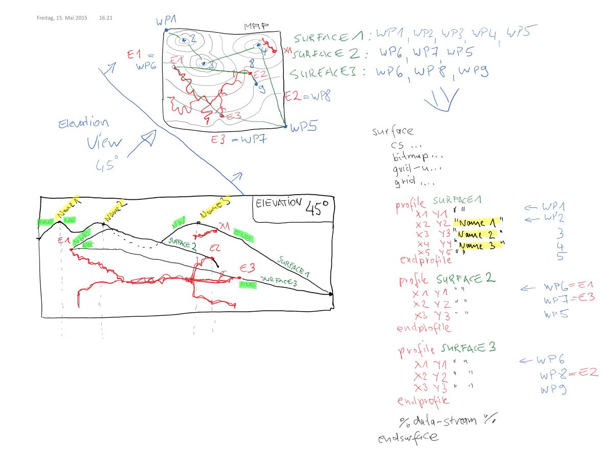
Hi Bruce,
Ok, only a  waypoint-block per line in the surface statement should be
enougth to create manually something and still control it free.
I've attached an idea.
A single waypoint could have a name, that printed to the map.
A automatic description of the cardinal/ordinal direction would be very
nice.
Problematic could be, that above the highest surface-profile is now air. And
the background-colour should be switched off?

dirk


Date: Fri, 15 May 2015 19:50:28 +1200
From: Bruce <br...@tomo.co.nz>
Subject: [Therion]  Idea: elevation projection surface panorama
To: 'List for Therion users' <therion at speleo.sk>
Message-ID: <E2AFDCBE938848648B4643A1DB5B3266 at JUICEBRAIN>
Content-Type: text/plain; charset="us-ascii"

Seems like a good idea for the wish list Dirk.

'Panorama' seems like the wrong word to me however.


Conceptually, what you describe would compliment the 'surface' statements we
already have in Therion.


In layouts we already have;


surface [top|bottom|off] that is only really relevant to layouts used with
plan projections.


What you describe would be the natural extension to a projected elevation
context.

So for elevations, your elevation-panorama [on|off] would be surface
[top|bottom|off] (ie do the surface profile drawing layers display over or
beneath the cave drawing), and elevation-panorama grid would be surface
grid.


As you suggest, some way of defining the grid spacing and or a profile trail
would be required.

If I were to use such a feature I would probably want to define sets of
way-points that I could call up at will.


I could imagine using them for extended elevations as well.  In that case
one would need to be able to set the profile to 'extend left' or 'extend
right', as, like extended centerlines themselves, the shape of the surface
becomes an artistic endeavor.


Bruce

  _____

From: therion-bounces at speleo.sk [mailto:therion-boun...@speleo.sk] On Behalf
Of Dirk Peinelt
Sent: Friday, 15 May 2015 3:29 a.m.
To: therion at speleo.sk
Subject: [Therion] Idea: elevation projection surface panorama


Hi mappers!

I've an idea for a new Therion-feature.

The feature affects only the elevation view, in a stated view direction.

The target is, to get a map with a elevation projection and a reference to
the surface.


If a surface is integrated in the project, it could be used to generate
automatically a surface-panorama from the surface point-cloud, on the basis
of the elevation-view-direction. And this could be printed to the elevation
map.

(like http://www.viewfinderpanoramas.org/panoramas.html)


With an layout option should it be controlled: e.g.:

elevation-panorama on|grid|off


off:

no surface panorama (default)


on:

One panorama piece, calculated from view direction and the middled object
extension.

Or serval panorama pieces, one per entrance reference or/and the panorama
was calculated by topographic prominence in the integrated surface.

(http://en.wikipedia.org/wiki/Topographic_prominence)


grid:

serval panoramas (each calculated on the grid value, opaque on top of each
other)


Optional:

With a waypointlist in the surface block could be peak's or other interessts
marked.

Or with a new fixed station flag, e.g. "peak".


This would be a nice feature.

Is this possible? Or absolutely utopistic?


//dirk

-------------- next part --------------
An HTML attachment was scrubbed...
URL:
<http://mailman.speleo.sk/pipermail/therion/attachments/20150515/685c9be2/at
tachment.html>

------------------------------

_______________________________________________
Therion mailing list
Therion at speleo.sk
http://mailman.speleo.sk/mailman/listinfo/therion


End of Therion Digest, Vol 113, Issue 8
***************************************
-------------- next part --------------
A non-text attachment was scrubbed...
Name: WP1.jpg
Type: image/jpeg
Size: 113059 bytes
Desc: not available
URL:
<http://mailman.speleo.sk/pipermail/therion/attachments/20150515/06ab1775/attachment.jpg>